
Mapping Your Way
E N D
Presentation Transcript
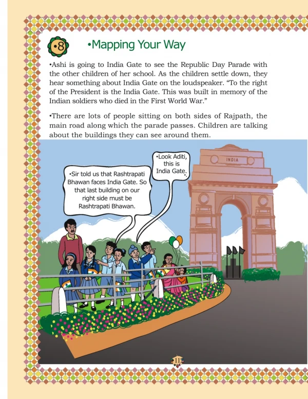
8 Mapping Your Way Ashi is going to India Gate to see the Republic Day Parade with the other children of her school. As the children settle down, they hear something about India Gate on the loudspeaker. “To the right of the President is the India Gate. This was built in memory of the Indian soldiers who died in the First World War.” There are lots of people sitting on both sides of Rajpath, the main road along which the parade passes. Children are talking about the buildings they can see around them. Sir told us that Rashtrapati Bhawan faces India Gate. So that last building on our right side must be Rashtrapati Bhawan. Look Aditi, this is India Gate. . 112
Here is a photograph taken from a helicopter. You can see Rajpath — the road which joins India Gate to Rashtrapati Bhawan. Mark where on Rajpath will Aditi be. Map 1 Rashtrapati Bhavan Vijay Chowk Rafi Marg Rafi Marg Rajpath Janpath Janpath Rajpath Man Singh Rd National Stadium Match the map and the photo Have you seen a map of a city? Look at Map 1. Match it with the photo and find out where India Gate is. Draw it on the map. Some roads are shown in this part of the map. Look for them in the photo. Name roads that you will cross on your way from Rashtrapati Bhawan to India Gate. Look for the National Stadium in Map 1. Can you see it in the photo?
The Central Hexagon If we ‘zoom in’ to look more closely at one part of the map, it looks like this. Janpath Rajpath Map 2 Man Singh Rd Man Singh Rd India India Gate Pandara Rd Copernicus Marg Children's Park National Stadium Look at the shape of the yellow area. Have you seen this shape before? How many sides does it have? This place is called the Central Hexagon. Find out from the map 1) If you are walking on Rajpath then after India Gate on which side would Children’s Park be? 2) Which of these roads make the biggest angle between them? Man Singh Road and Shahjahan Road Ashoka Road and Man Singh Road (the angle away from India Gate) Janpath and Rajpath 3) Which of the above pairs of roads cut at right angles?
Waiting for the Parade While waiting for the parade, Kancha and some of his friends wonder where this parade ends. Kancha is carrying a newspaper in which the route of the parade is written — Vijay Chowk — Rajpath — India Gate — Tilak Marg — B.S. Zafar Marg — Subhash Marg — Red Fort. NORTH Map 3 The children look at this map to see the parade route. Red Fort Chandni Chowk Rd Jama Masjid Raj Ghat WEST Medical College Connaught Place EAST Doll's Museum I.G. Stadium Pragati Maidan Rashtrapati Bhavan Vijay Chowk Janpath Rafi Marg National Stadium 11 Murti SOUTH Scale: 2 cm = 1 km 115
Hey! See, that is India Gate and this is Rashtrapati Bhawan. And the long road between these is Rajpath. Let's guess how many kilometres My mother told me it is 2 km from Vijay Chowk to India Gate. long Rajpath is. On this map, it is about 4 cm. So 4 cm on the map is the same as 2 km on the ground. You are right! See, it is written at the bottom of this map. Scale: 2 cm = 1 km Mark the route Trace the route of the parade in Map 3 and mark India Gate and Rajpath. • Look at the map carefully and find out: • a) Which of these is the longest road? • B.S. Zafar Marg • Subhash Marg • Tilak Marg • If Rubia is coming from Jama Masjid to join the parade, guess about how far she will have to walk. • The total route of the parade is about how long? • 3 km • 16 km • 25 km • 8 km • As the parade passes by, they see some children coming on an elephant. These children have got bravery awards. They also enjoy the colourful dances and aerobics by school children. • They want to follow the parade to Red Fort. Gappu has seen Red Fort before and tells them about his trip. Children should understand the need for a scale. We need to discuss that when we show a big area on paper, we have to reduce it by a fixed ratio everywhere, so that the relative distances and positions remain the same. 116
Trip to Red Fort "When we reached Red Fort, there was a long queue for tickets. The main entrance is called Lahori Gate. After entering it, we turned left into a long corridor with little shops on both sides. This is called Meena Bazar. I bought some lovely bangles from there for my sister". Meena Bazar Lahori Gate EAST Map 4 Yamuna River Ring Road Hammam Aram Gah Moti Masjid Rang Mahal Moti Mahal Diwan-e-Khaas NORTH Diwan-e-Aam Red Fort SOUTH Naqqar Khana Meena Bazar Lahori Gate WEST Subhash Marg Scale: 1 cm = 100 m 117
Naqqar Khana — where drums were beaten to shout out the king's messages You can go straight through Naqqar Khana and reach Diwan-e-Aam. This is where the king used to meet the common people. Walking straight from Diwan-e-Aam, we saw Rang Mahal. It is a beautiful building! There were three more buildings on our left side. Look for these on the map. We walked left from Rang Mahal. Diwan-e-Khaas was where the king used to meet his ministers and other important (khaas) people. From the right – Rang Mahal, Aaram Gah and Diwan-e-Khas Inside Rang Mahal Inside Diwan-e-Khaas Find out from Map 4 Which of these is nearer to river Yamuna? — the Diwan-e-Aam or the Diwan-e-Khaas? Between which two buildings is Aaram Gah? Which buildings do you pass while going from Rang Mahal to the Hammam? Which building on this map is farthest from Meena Bazar? About how far is Lahori Gate from Diwan-e-Khaas? 118
Make It Bigger, Make It Smaller. Here are some pictures drawn on a 1 cm square grid. Try making the same pictures on a 2 cm grid and also on a 1 2 cm grid. One picture is already done. 1 2 cm grid 1 cm grid 2 cm grid The side of the square was made two times bigger. Does its area also become two times bigger? Enlarging or reducing of pictures and maps can be done on the classroom floor, the mud ground etc. This should be related to the use of scale in maps, which keeps the shape the same. 119
Now try this — This is a part of the parade-route Map 3. Can you see which part of the route- map it is? Now try to make it bigger in this 2 cm grid. Remember that the ‘shape’ of the map should not change. 1 cm grid If the parade route map is smaller, and the distance between India Gate and Vijay Chowk becomes 2 cm, what would be its scale? • 1 cm on map = 1 km on ground • 1 • cm on map = 1 km on ground • 2 • 2 cm on map = 1 km on ground 2 cm grid Dancers from Different States The children saw many floats (jhankis) and dancers in the parade. Dancers from Karnataka were the best. I liked the Tripura dance. From Tripura and Sikkim they have to travel far, but Haryana and Uttarakhand are closer to Delhi. All these people have to travel so much to come to Delhi! 120
Look at the map of India below and find the states these children are talking about. Answer the questions: Map 5 This map is made on an approximate scale, so that children can easily estimate distance, area and directions. 1) The Karnataka team starts from Bangalore and moves in the north direction. Which states does it cross to reach Delhi? As the children are being introduced to directions for the first time, many activities need to be done to use terms like 'towards north', 'southwards', 'in the east direction', 'to the west of Madhya Pradesh' etc. One can draw maps on the floor and get children themselves to stand on the map and say things like Venkat is to the south of Shanti', 'Maharashtra is to the east of Gujarat' etc. 121
2) Jammu and Kashmir is to the north of Delhi so the team from there travels towards south to reach Delhi. Which states does it cross? 3) Nonu lives in Gujarat. Nonu's friend Javed lives in West Bengal. Nonu wants to visit his friend. In which direction will he travel? Towards west Towards east Towards south Towards north 4) Is there any state which is to the north of Jammu and Kashmir? 5) Is there any state which is to the west of Gujarat? 6) If 1 cm on the map shows 200 km on the ground, use this scale to find out: About how far is Delhi from Jaipur? a) 50 km b) 500 km c) 250 km Estimate, how far is Jaipur from Bhopal? On the map = _______ cm. On the ground = _______ km. 7) Look at the map and tell: Which state is surrounded by four other states? Which state has the largest area? If its name is not in the map, find it from your teacher or parents. Explain how you got your answer. Which state is about 8 times bigger in area than Sikkim? • Uttar Pradesh • Tripura • Maharashtra • Himachal Pradesh d) About how many times of Punjab is the area of Rajasthan?
The Sea Bala is standing on the sea-coast and looking at the vast sea. The sea looks endless . Have you seen the sea? In the picture where is the sea? Now look for the sea in the map of India. What colour is used to show the sea? Mark those states which have the sea on one side. Name one state which does not have the sea on any side. Find out Look for different maps. Compare the different scales used in a local area map, a map of India and a world map etc. Lines between the States Sabu is confused about the lines shown between the states. I travelled from Delhi to Haryana, but I never saw any lines on the ground. How do we see them on the map? No, there are no lines painted on the ground! The map shows us where one state ends and the next begins. O yes! We paid the toll-tax at the border. I saw a big board saying — Welcome to Haryana.
Map 6 Distances between Towns These are five towns. Find out: How many cm away is Idlipur from Barfinagar on the map? How many kilometres will you have to travel if you go from Idlipur to Barfinagar? Bhelpur Chholaghat Dhoklabad Barfinagar Idlipur Scale: 1 cm on the paper = 10 km There is a place called Thukpagram midway between Idlipur and Barfinagar. Mark it with a 'T'. A town called Jalebipur is 35 kms away from both Chholaghat and Dhoklabad. Where do you think it can be? Mark 'J' for it. Measure the length of the route between Bhelpur and Chholaghat. (You can use a thread) Ashi's School Ashi’s school looks like this from the top. Use the squares to find out: Map 7 Scale: 2 cm = 5 m 124
How many times bigger is the area of the Assembly ground than that of the office? How much is the length and width of each classroom? a) length 5 m, width 4 m b) length 2 m, width 1 m c) length 12 m, width 10 m d) length 5 m, width 5 m All the classrooms in Ashi’s school look like this. Blackboard Map 8 Window Door Benches Window Notice board Almirah Display board Look carefully and answer. Which of these is exactly opposite to the blackboard? + Almirah, windows, notice board, display board Now look at the school-map again. Guess and mark where would these be: + Blackboard in III A and VII + Almirah in IV and X + Notice board in V and VI B + Last seat of middle-row in II + Display board in I. Can a child sitting in III A see the playground?