Download
1 / 23
230 likes | 352 Vues
Niijima, a stunning island located in the Philippine Sea, is part of Japan's Izu Islands. Spanning 6.8 miles long and 1.6 miles wide, it features breathtaking cliffs and pristine white sandy beaches formed by ancient volcanic activity. With an average population of 2,700, Niijima offers warm, humid summers and cool winters, making it an ideal spot for surfing. Visitors can enjoy diverse tidal patterns, excellent swell conditions during typhoon season, and rich marine life. Access is easy via short flights or ferry from Tokyo, perfect for surf enthusiasts.

E N D
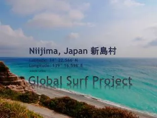
Global Surf Project Niijima, Japan 新島村 Latitude: 34° 22.566' NLongitude: 139° 16.598' E Joseph LeRoy
Niijimais located in the Philippine Sea and is apart of the Izu Islands. The population is around 2700 and the dimensions of the island are 6.8 miles long and 1.6 miles wide. Niijima has many cliffs as well as white sandy beaches which are a result from rhyolite lava that formed the island. Background and History
There are no active volcanoes on Niijima its self, however there are several active volcanoes in the Izu Islands. • Ōshima – 1990 • Miyake-jima - 2005 • Tori-shima – 2000 Background and HistoryContinued
Niijima’s weather varies by season. With February being the warmest coolest month of the year for Niijima, the average temperatures you might experience would be a high of 53F and a low of 43F. The warmest month of the year would be August with an average high of 84F and a low of 75F. The temperatures are generally much warmer and uncomfortable as Japan is generally a very humid region. Those temperatures might very well feel close to 100F or more on the hottest days of the year. You will also generally find the most rain accumulation in October with an average of 16” of rain for the month and with the least amount you find December only having accumulated 6” of rain. During the warmest month of August you will normally experience 7” of rain and in February you will normally see 6.5” of rain. Weather Patterns
The wind speeds in Niijima generally stay around the same speed year round, averaging 11 miles per hour. In September and October you will normally see the largest gusts of wind reaching up to 77 miles per hour. September and October is normally when most regions in Japan experience the peak of the Typhoon season resulting in the most amount of rainfall and the largest amount of waves. During the typhoon season in September and October you might find the swell ranging from an average of 6 feet to a high of 25 feet depending on the category of the typhoon. The water temperature surrounding Niijima changes with the seasons as well. The warmest sea temperature is in August with an average of 81F and the lowest being in February with an average of 63F. If you plan on surfing during the winter in Niijima you might want to bring a wetsuit with boots to stay warm. In the summer, board shorts are fine as the sun and the water temperature will keep you warm. Weather Patterns
Tides and Currents Mixed / Semi-diurnal tide is what is displayed for Niijima. Beginning in the early morning you will start off with a flood current, reach the maximum tide at 04:39. During the morning hours you will move to an ebb current and reach slack water around 10:00. In the afternoon this pattern will repeat itself.
The nearest tidal station is located roughly 5 miles from the larger island of Niijima, on the island called SikineSima. The tidal pattern observed in this area would be classified as a mixed semi-diurnal. There are two high and two low tidal heights throughout the tidal daywhich can vary depending on the time of year, month, etc. Tides and CurrentsContinued
NOAA Wave Watch 3 suggests that the best swell direction comes from a south swell. During the Japanese Typhoon season, you will undoubtedly see an increase in swell height and speed. Niijima is affected by the most violent typhoons as well as the Kuroshio Current, that play a role in the swell height and direction. The Kuroshio Current travels at a rate of about 3 miles per hour, or about 75 miles per day. Swell Directions
Generally the type of bottom you will find in the Niijima and Izu Island chain is a sandy and rocky bottom. This is a result of volcanic eruptions that occurred around the 9th century. On the coast of Niijima, the depth of water drastically increases less than a mile off the coast. You’ll generally experience very deep water on many of the beaches in Japan, and other islands for that matter which might be different than what you’ll find in many of the shores of New Jersey and surrounding areas. You’ll tend to find a lot of beach breaks and shore breaks due to the bathymetry off the coast of Niijima. Bathymetry
Planning your trip to Japan will defiantly cost a large amount of money. During the Summer months you will expect to pay on average $1600 to $1800 for a round trip airline ticket. The cheapest time to fly to Japan is during autumn, and you will pay anywhere from $1000 to $1400. The average price to fly your surfboard is about $150 - $200. Your best option would to rent from a local surf shop to save the time and money it would cost to carry your surfboard. The duration of the flight lasts roughly 12 to 14 hours. From Tokyo, you will have three options to arrive in Niijima. You can either take a 45 minute plane ride, a 2 ½ hour jet boat or a 9 hour overnight ferry which leaves from TakeshibaSanbashi Pier, located in Tokyo. Prices vary, starting at 6000JPY to 19000JPY. Planning Your Trip
The local crowd in Japan is generally very friendly. You’ll defiantly make friends in and out of the water. Most Japanese nationals speak a decent amount of English, however some are not fluent in English at all. These people you would normally keep to themselves and not interact with English speakers. A lot of Japanese enjoy drinking and making friends with foreigners who they just met. I think you’ll have a great time if you’re social and enjoy learning a little bit of Japanese during your trip. If you’re going during the winter you would defiantly want to bring a wetsuit, however in the summer you will not need one. Renting a surfboard is somewhat expensive. For a short board you can expect to pay 4000JPY ($50USD), and or a long board about 5000JPY ($60USD). Planning Your Trip
Niijima camping is the most popular method for getting rest after an exhausting day in the water or traveling the island. The best thing is that it’s the cheapest option for getting some rest. It’s free! Instead of spending money on a hotel, you can just bring a tent or rent one and interact with everyone else at the campground. I think that would make for a much more enjoyable island trip anyways. Images
http://chipango.wordpress.com/2011/08/20/island-escape-to-niijima/http://chipango.wordpress.com/2011/08/20/island-escape-to-niijima/ http://en.wikipedia.org/wiki/Kuroshio_Current http://niijimawavereport.sblo.jp/ http://en.wikipedia.org/wiki/List_of_volcanoes_in_Japan http://en.wikipedia.org/wiki/Nii-jima http://magicseaweed.com/spot-seasonal-overview.php?spotId=602 http://www.surf-forecast.com/breaks/Niijima-Habushiura/reliability_by_season http://wikitravel.org/en/Niijima http://www.tokaikisen.co.jp/english/time_price/time_price/ Sources
じゃまたね! See you later!