Download
1 / 119
1.28k likes | 1.68k Vues
SOCIO-ECONOMIC BASELINE SURVEY OF CHITTAGONG HILL TRACTS. SOCIO-ECONOMIC BASELINE SURVEY OF CHITTAGONG HILL TRACTS. Prepared for presentation at LCG Sub-Group on The Chittagong Hill Tracts. Prepared by The Study Team. Organized by United Nations Development Programme, Dhaka.

E N D
SOCIO-ECONOMIC BASELINE SURVEYOFCHITTAGONG HILL TRACTS • Prepared for presentation at • LCG Sub-Group on The Chittagong Hill Tracts Prepared by The Study Team • Organized by • United Nations Development Programme, Dhaka Dhaka: March 09, 2009
Presentation Sequence • Background: CHT & CHTDF-PDCB • Study objective & Methodology • Key Findings: • Para Profile • Household Background Information • Migration & Displacement Scenario • Land Ownership, Possession & Dispossession • Household Assets & Housing • Employment Scenario • Agriculture & Crop Production • Household Income & Expenditure • Household Savings & Credit • Food Consumption, Food Security & Poverty • Education • Primary Health Care • Water, Environmental Sanitation & Hygiene • Access to Local Government, Nation Building Institutions & Community Empowerment • Women & Development • Knowledge on Chittagong Hill Tracts Accord 1997 • Conflicts & Violence Scenario • Peace & Confidence Building
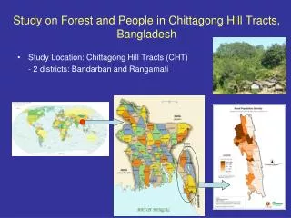
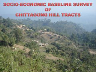
Background of Chittagong Hill Tracts The Chittagong Hill Tracts (CHT) region appears as a crucial political & development discourse among academicians, researchers, & politicians for its diversity & gravity in geography, population, displacement, & Bangalee settlement among others.
Why CHT is Important • Majority indigenous peoples (1.3 million) of Bangladesh lives in CHT • A total of 11 indigenous communities namely Bawm, Chak, Chakma, Khyang, Khumi, Lushai, Marma, Mro, Pangkhua, Tanchangya &Tripura • A large number of indigenous peoples were displaced/dislocated due to construction of Kaptai Dam in 1950s • Around 400,000 poor Bangalees transmigrated to CHT (post 1975) • Most deprived & excluded section of population
About CHTDF-PDCB • Overall objectiveis to support Government of Bangladesh, & to further enable CHT institutions & communities, to pursue accelerated & sustainable socio-economic development based on principles of self-reliance & decentralized development initiatives, in order to reduce poverty across region and building greater confidence & trust for resolving long-standing issues critical to development & peace. • CHTDF-PDCB financed by multi-donor agencies: European Commission, USAID, NORAD, AUSAID, Japan, Canada, UNDP.
Study Objective • BroadObjectiveof survey was to provide estimates of selected socio-economic characteristics of population that will serve as baseline for assessing progress & impact of UNDP-CHTDF interventions. • Specific Objectives: • Provide estimates of selected socio-economic characteristics of CHT population • As a whole • All indigenous peoples • Individual indigenous community • Bangalees
Qualitative Techniques • Focus Group Discussion • Stakeholder Consultation Meeting
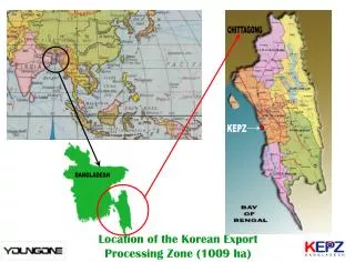
CHT Region in Bangladesh (shaded area) PANCHAGARH THAKURGAON LALMO NILPHA NIRHAT MARI DINAJPUR KURIGRAM RANGPUR INDIA GAIBAN DHA SHERPUR JOYPUR HAT SUNAMGANJ SYLHET NAOGAON JAMALPUR NETROKONA BOGRA MYMENSINGH NAWAB GONJ MOULAVI BAZAR SIRAJGONJ RAJSHAHI KISHOREGONJ NATORE INDIA HOBIGONJ TANGAIL GAZIPUR PABNA INDIA BRAHMAN NARSINGDI BARIA KUSHTIA MEHER MANIKGONJ N' DHAKA PUR GONJ CHUA RAJBARI DANGA JHENAIDAH MUNSHI GONJ MAGURA FARIDPUR KHAGRA CHANDPUR COMILLA SHA MADARI JESSORE RIAT PUR CHHARI NARAIL PUR GOPAL GONJ LAXMI FENI PUR NOAKHALI BARISAL RANGAMATI PIROJ KHULNA BHOLA SATKHIRA CHITTA PUR GONG JHALO BAGERHAT KATI Sandwip PATUA KHALI Hatiya BARGUNA BANDARBAN Kutubdia COX'S BAZAR M A Y BAY OF BENGAL A N M A R
Chittagong Hill Tracts - Study Area • 200 Para/villages • 29 Unions of • 13 Upazilla • 3 CHT Districts
Population, Household & Composition of Para by Ethnicity • Average number of HH/Para = 46 • Average population/Para = 241
HOUSEHOLD BACKGROUND INFORMATION
Household Size National rural household size 4.9
Dependency Ratio National rural dependency ratio 81.87
Average Years of Schooling Calculation procedure considers those who are 5 yrs. & above
Incidence of Migration before CHT Accord (1997) (% hh) # persons displaced before 1997: 371,000 (53,000 hh x 5.2)
LAND OWNERSHIP, POSSESSION & DISPOSSESSION
Land Ownership Status Scenario 1: Considering only Registered Land (% hh)
Land Ownership Status …Contd… Scenario 2: Considering Registered & Customary Recorded Land (% hh)
Land Ownership Status (%) …Contd… Scenario 3: Considering Registered, Customary (recorded & unrecorded) & Common Property (% hh)
Incidence of Land Dispossession : 1977-1997 (% hh) Note: For settler Bangalees land dispossession happened, in most of the cases, who did not get the land as per deed given by Govt.
Amount of Land Dispossessed (in decimal) Total amount of land dispossessed by IPs: 33,000 acres
HOUSEHOLD ASSETS & HOUSING
Household Assets Valuation (in ‘000 Tk.)
Nature of House (% hh)
HH Electrification Status (% hh)
EMPLOYMENT SCENARIO
Employment Status • Note: • Employable person means 15 yrs.+ & not in schools • Student, 60 yrs.+, sick & disable are excluded
Nature of Employment (in %) • Note: • Full time employed means employment for > 6 months • Partial/seasonal employed means employment for < 6 months
Firewood Collection: Male/Female (% reported)
Time for Firewood Collection (hr./year) • An indigenous woman spends around 30 minutes per day • A Bangalee woman spends around 32 minutes per day • Male HH member of indigenous peoples spends 20 minutes per day • Male HH member of Bangalee spends 21 minutes per day
Major Crop Produced (%hh) Note: More than 35 types of crops are produced in CHT
Paddy Production : Indigenous Peoples (Productivity: maunds/acre )