Download
1 / 1
20 likes | 247 Vues
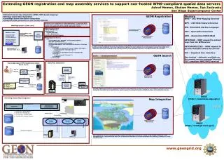
GEON Registration. GEON Metadata Catalog. registerWMS(URL, ADNXML, OntologyMappingXML). GEONRegistration Web Service. GEON Search. GEON Metadata Catalog. GEONSearch Web Service.

E N D
GEON Registration GEON Metadata Catalog registerWMS(URL, ADNXML, OntologyMappingXML) GEONRegistration Web Service GEON Search GEON Metadata Catalog GEONSearch Web Service Extending GEON registration and map assembly services to support non-hosted WMS-compliant spatial data servers Ashraf Memon, Ghulam Memon, Ilya Zaslavsky San Diego Supercomputer Center • Standards based map integration (WMS, WFS based mapping) • Ontology based data registration • Knowledge based information integration • Composite map generation to non-hosted datasets Glossary WMS – OGC Web Mapping Services WFS – OGC Web Feature Services XML- Extensible Markup Language OGC – Open GIS Consortium ADN – Alexandria DLESE NASA GETIMAGE – WMS request to extract map from the WMS server GETCAPABILITIES – WMS request to get the metadata about the service GUI – Graphical User Interface Non-hosted – datasets available on the remote servers exposed through OGC compliant WMS/WFS services WMS service is a collection of spatial data layers. To make the WMS service layers available to the community through GEON, the service needs to be registered with the GEON registration system. WMS Registration (Item Level) • Metadata Requirement • URL to WMS Service • ADN Metadata • Spatial Envelope • Other Dublin Core • Item Level Ontology Mapping • WMS Server URL: • Interactive ADN • metadata entry • (For Each Service) • Ontology Mapping • Interactive GUI • (For Each Service) WMS Registration Service registerWMS (URL, ADNXML, OntologyMappingXML) • WMS Registration Service • API • registerWMS( URL, ADNXML, OntologyMappingXML ) • URL: URL to WMS Service • ADNXML: XML defining ADN Metadata • OntologyMappingXML: xml defining WMS dataset to Ontology, sample • <ontologies> • <ontology id=“geon1234” name=“SWEET Ontology”> • <concept name=“Geologic Age”/> • </ontology> • <ontology id=“geon5678” name=“Geologic Age Ontology”> • <concept name=“Jurassic”/> • </ontology> • </ontologies> submit During the GEON registration process a reference to the WMS service is stored along with the metadata (list of layers, other dublin core type metadata). Item level registration registers the whole dataset to an ontological concept, item detail level registration stores the mapping of the individual values in the database columns to concepts stored in the ontology. GEON Metadata Catalogue GetCapabilities (Spatial Extent etc.) Basic Map Integration Knowledge Based WMS Registration (Item Detail Level) WMS Map Assembly Portlet/Viewer • WMS URL • WFS URL GET_CAPABILITIES WMS Registration Portlet WMS Server GET_VALUES (fields) Envelope Layers Interactive Client Type XML result URL WFS Server WMS Registration Service Compile WMS Map Assembly Service Website Creator • WMS URL • WFS URL • Dataset Name • Ontology • Concept Value Map Ontologies and Concepts GEON Metadata Catalogue Image Fusion Service REGISTER Concept mapping information, obtained during item level registration, is used to search for the datasets. Concept map stored during the item detail level registration is used to query the concepts stored as individual values in the datasets columns. WMS Servers USGS (http://seamless.usgs.gov) Knowledge Based Map Integration Map Integration Geon Dataset Ids Client Portlet Map Integration Portlet (Mediator) WWW Gridsphere GEON Metadata Catalog • Dataset Ids to Dataset Names • Dataset Ids to Ontology Ids • Ontology Ids to Ontology Names • Ontology Ids to Ontology Concepts Redefine Query Generate Map GEON Metadata Catalogue Execute Query Mapping /Fusion Services OGC Query Service Ontology Service MapIntegration Web Service Webservices NASA (http://wmt.jpl.nasa.gov) Knowledge Representation Mapping Query Tracking Database Query Result Indexing Ontology Engine Map integration service assembles multiple fragments of the maps received as a result of the GetMap request in to one composite layer, and provides the user with an interactive interface to perform operations like zooming, panning etc on the combined map. WMS Server