Download
1 / 11
110 likes | 254 Vues
The Weather Forecast Office in Charleston, SC (WFO CHS) has actively engaged in the GOES-R Proving Ground initiative since 2005, participating in numerous conferences, workshops, and training sessions. Key milestones include the ingestion of advanced satellite products into AWIPS, participation in virtual satellite workshops, and contributions at national conferences. As WFO CHS continues to integrate innovative data sources like SNPP and UW-CIMSS into operations, future training will focus on enhancing the use of experimental data and improving forecast accuracy.

E N D
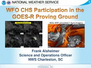
WFO CHS Participation in the GOES-R Proving Ground Weather Forecast Office Charleston, SC
WFO CHS Participation Timeline • 2005: Became a member of the SRSST/SOAWG • 2006: Attended first GOES-R User’s Conference in Broomfield, CO • 2009: Made two presentations at GOES-R Proving Ground Meeting in Boulder, CO • 2009: Made a presentation at the GOES-R User’s Conference in Madison, WI • 2010: Attended the Spring Hazardous Weather Experiment (using CTC, proxy lightning, etc.) • 2010: Starting ingesting UW-CIMSS GOES-based convective products into AWIPS for operational use. • 2010: Hosted the first ER virtual satellite workshop. • 2012: Started ingesting NSSL-WRF Simulated Satellite Imagery into AWIPS for operational use. • 2012: Made a presentation (virtually) on the use of simulated satellite imagery in operations at the 2012 National Weather Association annual meeting in Madison, WI. (Made the presentation again virtually for ER offices) • 2013: Co-hosted the second ER virtual satellite workshop. • 2013: Started ingesting SNPP imagery into AWIPS. • 2014: Made a presentation on the UW-CIMSS CTC product for both a GOES-R Brown Bag webinar and at the Palmetto Chapter of the AMS Mini-Tech. Weather Forecast Office Charleston, SC
Training Experiences • COMET • Several live COMET teletraining sessions were scheduled for the staff. • Recorded versions assigned in staff learning plans • OTJ Training • Point out proper use of the data “live” • Encouraged staff to mention products in AFDs • Locally made presentations Weather Forecast Office Charleston, SC
Future Training Needs • BANDWIDTH • Training available for all new “experimental” data. • Training on the use of the products in concert with other sources of data (i.e. radar, mesoanalyses, model output, etc.) • Focus on the added value to the entire forecast/warning process. • Continue to expand the use of GOES-R (and SNPP) products in Weather Event Simulations to aid integration. Weather Forecast Office Charleston, SC
UW-CIMSS Cloud Top Cooling Strengths Weaknesses • Best for initiation. • Documented cases where the product produced superior lead time to radar alone. • Clean display which can be overlayed on satellite data in AWIPS. • Easy product to understand. • Cirrus shield renders product ineffective. • False Alarms can be large for severe thunderstorms. • Often times radar gives indicator before CTC signal. • (Potentially due to current limitations of GOES temporal resolution) Weather Forecast Office Charleston, SC
NSSL WRF Simulated Satellite Strengths Weaknesses • Excellent visualization tool. • Encourages the use of “alternative” imager bands. • Allows quick estimate of the models performance. • Nicely compliments simulated radar products. • Relatively easy to understand. • Only as good as the model output. • Hourly temporal output vs. more frequent satellite imagery. • Model only run once a day. Weather Forecast Office Charleston, SC
SNPP Data Strengths Weaknesses • Provides feature identification/texture that would otherwise be difficult to get. • Day-Night band allows for details impossible to see from traditional nighttime imagery. • All the typical polar orbiter issues • -- Latency • -- Temporal Frequency Weather Forecast Office Charleston, SC
Potential Improvement Areas • Cloud Top Cooling • Use SRSOR examples to recalibrate product for 5 minute and 1 minute scans. • Integrate radar and near storm environment data into the algorithm. • Operational Readiness: Needs some improvement to be reliably effective. • Simulated Satellite Imagery • Expand to other models that are run more frequently and have higher spatial/temporal resolution (HRRR). • Add in enough simulated channels to also simulate RGB imagery. • Operational Readiness: Yes, but needs to be expanded to other models for the true value to be appreciated.