Download
1 / 18
180 likes | 299 Vues
This document outlines proposed amendments to the Comprehensive Plan regarding the Coastal High Hazard Area (CHHA) and Future Land Use Map. Amendments include updating the definition of CHHA to align with HB 1359 and reclassifying specific areas of the City of Palm Coast from Agriculture and Timberlands to Institutional and Mixed Use. Staff recommendations support the proposed changes for consistency with the Comprehensive Plan's goals and objectives, enhancing community safety and land-use planning.

E N D
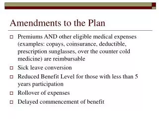
PROPOSED ACTION • Amend Policy 6.2.4.1 of the Coastal and Conservation Element and the Glossary to reflect the new definition of Coastal High Hazard Area per HB 1359. • Amend the Future Land Use Map to include the boundaries of the CHHA.
NEW DEFINITION • The City shall identify the Coastal High Hazard Area as [the area below the elevation of the Category 1 storm surge line as established by a Sea, Lake and Overland Surges from Hurricane (SLOSH) computerized storm surge model] prepared by the Northeast Florida Regional Council as part of the latest Hurricane Evacuation Study.
RECOMMENDATION • Staff recommends approval of the proposed text and map amendment
Background and Location Map • Applicant -City of Palm Coast • Owner – City of Palm Coast • Address – 50 Citation Blvd. • Current Use – Water Treatment Plant #2 • Current FLUM – Agriculture & Timberlands • Current Zoning – Agriculture • Proposed FLUM – Institutional
EXISTING FUTURE LAND USE MAP • North – Mixed Use • West – Mixed Use • South-Mixed Use, Residential-Low Density • East - Residential-Low Density
Existing Uses • North-Vacant • West-Vacant • South-Vacant • East-Vacant
FINDINGS • The proposed FLUM amendment and rezoning is consistent with the Goals, Objectives, and Policies of the adopted Comprehensive Plan.
RECOMMENDATION • Staff recommends approval of: • FLUM amendment application LU-MAJ-08-02 from County designation Agriculture & Timberlands to City designation Institutional.
Background and Location Map • Applicant -City of Palm Coast • Owner – Mario & Marylou Baiata • Address – Old Brick Rd. • Current Use – Nursery • Current FLUM – Mixed Use-High Intensity • Current Zoning – Commercial-2 • Proposed FLUM – Mixed Use
EXISTING FUTURE LAND USE MAP • North – Mixed Use-High Intensity • West – Mixed Use-High Intensity • South-Mixed Use-High Intensity • East – Mixed Use High Intensity, Industrial
Existing Uses • North-Vacant • West-Storage • South-Nursery, drainage easement • East-Mini warehouses, single family home
FINDINGS • The proposed FLUM amendment and rezoning is consistent with the Goals, Objectives, and Policies of the adopted Comprehensive Plan.
RECOMMENDATION • Staff recommends approval of: • FLUM amendment application LU-MAJ-08-04 from County designation Mixed Use-High Intensity to City designation Mixed Use.