Download
1 / 28
280 likes | 511 Vues
8 th Grade Science. DO NOW. Monday, October 15, 2012. On page ___ in your INB, name the three types of boundaries between tectonic plates and the crustal features that each type of boundary can create. 8 th Grade Science. Today’s Schedule. Monday, October 15, 2012. Do Now Quiz 8.9(B)

E N D
8th Grade Science DO NOW Monday, October 15, 2012 On page ___ in your INB, name the three types of boundaries between tectonic plates and the crustal features that each type of boundary can create.
8th Grade Science Today’s Schedule Monday, October 15, 2012 • Do Now • Quiz 8.9(B) • Newspaper Article and Special Assignment. Essential Question Vocabulary tectonic plate plate tectonics convergent divergent transform ridge trench island arc earthquake volcano How does the Earth’s surface change?
8th Grade Science Today we will… Monday, October 15, 2012 8.9(B) relate plate tectonics to the formation of crustal features
8th Grade Science Quiz Monday, October 15, 2012 Read and re-read the passage. Underline the question Bubble important words Identify the key idea, write it in margin. Eliminate the wrong answers Select the correct answer ✓ predator/prey interactions
8th Grade Science Newspaper Article Monday, October 15, 2012 Grade-Level Read: “Warm Lava on a Hot Planet” Write a Haiku Poem Instructions for writing a haiku poem can be found on page 2 of your INB.
8th Grade Science Newspaper Article Monday, October 15, 2012 Pre-AP Read: “Warm Lava on a Hot Planet” Pick an assignment from the Special Assignments Page in your INB (page 2)
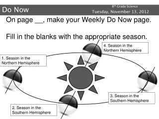
8th Grade Science DO NOW Tuesday, October 16, 2012 On page ___ in your INB, create a Venn Diagram comparing the topographical and physical maps at your table.
8th Grade Science DO NOW Tuesday, October 16, 2012
8th Grade Science Today’s Schedule Tuesday, October 16, 2012 • Do Now • Mt. Capulin Activity • Exit Ticket Essential Question Vocabulary contour line contour interval altitude successive topographic map satellite view land feature weathering erosion elevation depression mesa mountain hill runoff plain valley How does the Earth’s surface change?
8th Grade Science Today we will… Tuesday, October 16, 2012 8.9(C) interpret topographic maps and satellite views to identify land and erosional features and predict how these features may be reshaped by weathering.
8th Grade Science Mt. Capulin Tuesday, October 16, 2012
8th Grade Science Mt. Capulin Tuesday, October 16, 2012 • Mount Capulin Activity • Place plastic mountain in box. • Add Colored water to 1cm mark. • Place a transparency over the box and trace where the water meets the mountain. • Add water to 2cm line and repeat the same process. • Continue until you complete the 5cm mark.
8th Grade Science Mt. Capulin Tuesday, October 16, 2012
8th Grade Science Exit Ticket Tuesday, October 16, 2012 Describe a situation when a topographic map would be more useful than a physical map.
8th Grade Science DO NOW Wednesday & Thursday, October 17 & 18, 2012 On page ___ in your INB, make 5 observations about how the area has changed after erosion from El Nino.
8th Grade Science Today’s Schedule Wednesday & Thursday, October 17 & 18, 2012 • Do Now • Topographic Maps & Play-Doh • Weathering Activity • Nature Walk • Exit Ticket Essential Question Vocabulary contour line contour interval altitude successive topographic map satellite view land feature weathering erosion elevation depression mesa mountain hill runoff plain valley How does the Earth’s surface change?
8th Grade Science Today we will… Wednesday & Thursday, October 17 & 18, 2012 • 8.9(C) interpret topographic maps and satellite views to identify land and erosional features and predict how these features may be reshaped by weathering. • Today’s Objective: • To identify the elevations and physical features by looking at a topographical map. • Make predictions about how weathering and erosion will affect these land features.
8th Grade Science Topographic Map & Play-Doh Wednesday & Thursday, October 17 & 18, 2012 • Topographic Map & Play-Doh • Create an accurate model of each of the topographic maps using the clay. • When you have made each model, call your teacher and have the profile sketch initialed.
8th Grade Science Weathering Wednesday & Thursday, October 17 & 18, 2012 • Weathering Activity • Put sand in the plastic container and form a mountain. • Make 3 predictions about how weathering will affect the mountain. • Using a pipette, model a light rain and make observations. • Pour ¼ cup of water on the sand and make observations.
8th Grade Science Nature Walk Wednesday & Thursday, October 17 & 18, 2012 Nature Walk Find examples of weathering and erosion and how it has changed the topographic features of an area.
8th Grade Science Exit Ticket Wednesday & Thursday, October 17 & 18, 2012 Watch the video Which map more closely represents the mountain the biker went down. Why?
8th Grade Science DO NOW Friday, October 19, 2012 On page __ in your INB, list 3 differences between the images and write an explanation for what you think occurred.
8th Grade Science Today’s Schedule Friday, October 19, 2012 • Do Now • Brainstorm land features • Land feature drawings • Quick-write • Review Essential Question Vocabulary contour line contour interval altitude successive topographic map satellite view land feature weathering erosion elevation depression mesa mountain hill runoff plain valley How does the Earth’s surface change?
8th Grade Science Today we will… Friday, October 19, 2012 8.9(C) interpret topographic maps and satellite views to identify land and erosional features and predict how these features may be reshaped by weathering. Today’s Objective: To create a model of land features before and after erosion.
8th Grade Science Brainstorming Friday, October 19, 2012 • On page ___ in your INB, create a list of land features that are found on Earth. • Share your list with your shoulder partner. Add any features that were not on your list. • Share list with the class.
8th Grade Science Land Features Drawing Friday, October 19, 2012 • With a partner, select 3 of the land features that were brainstormed. • Create a before and after chart to illustrate the land features. • Draw the land feature in the “Before” column and then again in the “After” column in a way that shows the land being reshaped by water, wind, or other forms of weathering and erosion.
8th Grade Science Land Features Drawing Friday, October 19, 2012
8th Grade Science Quick Write Friday, October 19, 2012 Write for 2-3 minutes about what your Before and After drawings would look like from space.