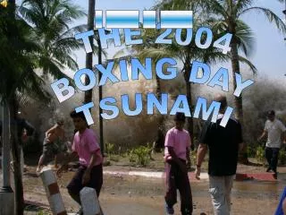
Tsunami 2004
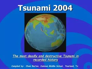
Tsunami 2004. The most deadly and destructive Tsunami in recorded history. Compiled by: Chani Barton, Jamison Middle School, Pearland, Tx . 2004 Indian Ocean Earthquake. 9.0 magnitude earthquake led to a sequence of 15 quakes across the Andaman region and caused the tsunami.

Tsunami 2004
E N D
Presentation Transcript
Tsunami 2004 The most deadly and destructive Tsunami in recorded history Compiled by: Chani Barton, Jamison Middle School, Pearland, Tx
2004 Indian Ocean Earthquake • 9.0 magnitude earthquake led to a sequence of 15 quakes across the Andaman region and caused the tsunami.
Tsunami – by definition • Series of catastrophic ocean waves generated by movements under the ocean (caused by earthquakes, volcanic eruptions, landslides, or an asteroid). • In the open oceans, wavelengths of up to several hundred miles and travel up to 450 miles per hour. Yet, wave heights can be less than 3 feet. • Wave height as they crash onshore depends entirely upon the submarine topography offshore.
Definition Continued • The first indication of an incoming tsunami is a large wave followed by a sudden outrush of water that exposes much of the coastline. • Principally occur following an earthquake of magnitude 6.5 or higher
Epicenter 150 KM west of Sumatra http://en.wikipedia.org/wiki/2004_Indian_Ocean_earthquake
Occurred along the subduction zone where the Indian dives under the Eurasian Plate http://www.nps.gov/prsf/geology/images/plates.gif
Facts • The earthquake came just three days after a magnitude 8.1 earthquake in an uninhabited region west of New Zealand • Possible connection between these two earthquakes • Possibility of a seismic chain reaction across neighboring plates has also been considered
Facts on Energy • Total energy released by a magnitude 9.0 earthquake exceeds the total amount of energy consumed in the U.S. in one year by 30% • Or, it is equal to the amount of energy released by the wind of a hurricane like Hurricane Isabel over a period of 70 days • This is the same amount of energy that would be required to boil 2,600 gallons of water for every person on Earth. • Massive release of energy and shift in mass insignificantly altered the Earth's rotation, possibly shortening the length of a day by 3 microseconds,and causing the Earth to “wobble” almost an inch on its axis. • According to Tad Murty, vice-president of the Tsunami Society, the total energy of the tsunami waves was more than twice the total explosive energy used during World War II, but was still 4 orders of magnitude less than the energy released by the earthquake itself! • Each unit on the Magnitude scale represents a 31.6 fold increase in energy… every two units signifies 1,000 times more energy!!!
Facts on Plate Movement • Sumatra is one of the most earthquake prone places in the world, sitting atop one of the handful of sites where several plates overlap and grind. • Subduction zones, where one plate dives under another, are where all the world’s largest earthquakes occur. • An estimated 750 mi of faultline slipped 60 ft along the subduction zone where the India Plate goes under the Burma Plate. • The seabed of the Burma Plate is estimated to have risen several meters vertically. • Movement of these plates is jerky, the submerging plate usually drags the upper plate with it until it breaks free and goes back to its original position. • The India Plate typically drifts Northeast at an average of 2 in/yr. This equates to 60 ft per 330 years. Therefore, the earthquake caused the fault to move 330 years-worth of distance!!!
A tsunami (pronounced soo-NAA-mee) is a series of waves (called a "wave train") generated in a body of water by a pulsating or abrupt disturbance that vertically displaces the water column.
Tsunami's are also mistakenly referred to as tidal waves as they often resemble a tide that keeps rising, rather than cresting waves when they reach shore. However, as they are not actually related to tides the term may be misleading, and its use is discouraged by scientists.
Tsunamis are created when: • Seafloor quickly changes shape • Water is displaced • Waves are formed as the displaced water mass, which is affected gravity, tries to move back Anthony Liekens 15:30, 28 Dec 2004 (UTC)
Characteristics • Move at high speeds • Can travel enormous distances with little energy loss • Can cause damage thousands of miles from its origin • May be several hours between its creation and its impact on the coast.
Warning Systems Many countries around the Pacific, including Hawaii, have warning systems and evacuation procedures in the event of a serious tsunami. Tsunamis in the Indian Ocean are rare, therefore they do not have such warning sytems in place!
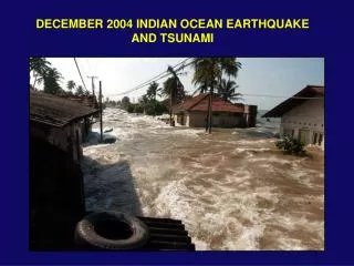
Effects of Tsunamis • Destruction of human life (100,000+) • Destruction of property • Spread of disease • Destruction of ecosystems • Awesome example of a fast change to the Earth’s Surface!
Constructive/Destructive • The earthquake was a constructive force because it caused the seabed to rise (building up). • The tsunami was a destructive force due to the huge amount of land that was eroded as the water receded (tearing down).
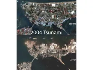
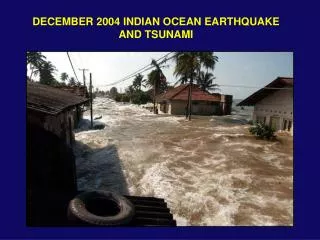
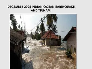
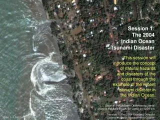
Tsunami - 2004 • The Tsunami killed thousands of people in Southern India, Sri Lanka, Indonesia, etc. In India, Andaman and Nicobar islands,Tamil Nadu, Pondicherry, Andhra Pradesh, Kerala were worst hit. • The following pictures show some portions of damage that occurred on the Andaman and Nicobar islands and part of Andhra Pradesh and Chennai coast. • In the images, red depicts vegetation, white depicts clouds and shades of blue indicate types of water. Some Images Courtesy: National Remote Sensing Agency
Port Blair Surroundings of Andaman and Nicobar Islands as observed from IRS-P4 and IRS-P6 satellites IRS-P4 OCM Image of 26-December- 2004 North Andaman IRS-P6 AWiFS Image of 26-Dec-04 Camorta Island South Andaman (Rutland Island) Trinkat Island South Andaman Little Andaman ANDAMAN SEA BAY OF BENGAL Nancowry Island Car Nicobar Katchall Island Camorta Island Nancowry Katchall Island Little Nicobar Great Nicobar
A Close View of Trinkat Island IRS-P6 AWiFS Image of 26-Dec-04 IRS-P6 AWiFS Image of 21-Dec-04 Pre-Event Post-Event
A Close View of Camorta Island IRS-P6 AWiFS Image of 21-Dec-04 IRS-P6 AWiFS Image of 26-Dec-04 Pre-Event Post-Event
A Close View of Camorta Island IRS-P6 AWiFS Image of 21-Dec-04 IRS-P6 AWiFS Image of 26-Dec-04 Pre-Event Post-Event
IRS-P6 L4 MX Images showing the situation in the surroundings of Kakinada Port in Andhra Pradesh 12-January-04 27-December-04 Pre-Event Post-Event Kakinada Bay Kakinada Bay
Part of Chennai City IRS-P6 L4 MX Image of 12-Jan-04 IRS-P6 L4 MX Image of 27-Dec-04 Marina Beach Marina Beach Pre-Event Post-Event
Part of Chennai City IRS-P6 L4 MX Image of 12-Jan-04 IRS-P6 L4 MX Image of 27-Dec-04 Adayar River Adayar River Pre-Event Post-Event
Part of Chennai City IRS-P6 L4 MX Image of 12-Jan-04 IRS-P6 L4 MX Image of 27-Dec-04 Adayar River Adayar River Pre-Event Post-Event
Machilipatnam Area, Andhra Pradesh IRS-P6 AWiFS Data 18-Dec-2004 27-Dec-2004 Bandar Fort Reserved Forest Bandar Fort Reserved Forest
The Most Devastating Earthquakes Since 1900 • May 22, 1960, Chile: 9.5 magnitude quake strikes Santiago area causing tidal waves and volcanic eruptions. • March 28, 1964, Alaska: 9.2 magnitude quake is felt over most of Alaska causing a tsunami that causes $311 million in property loss. • March 9, 1957, Alaska: 9.1 magnitude quake hits the Andreanof Islands, Mount Vsevidof erupts after being dormant for 200 years, sending a tsunami across the Pacific to Hawaii. • November 4, 1952, Russia: 9.0 quake generates a tsunami that heads toward Hawaii-no lives lost. • December 26, 2004, Indonesia: 9.0 quake strikes the coast of Aceh province on the island of Sumatra sending a tsunami that kills hundreds of thousands and reaches as far as Somalia on the coast of Africa.
Resources • www.infoplease.com • http://en.wikipedia.org/wiki/Main_Page • www.cnn.com • http://iri.columbia.edu/~lareef/tsunami/ • http://www.oceansonline.com/tsunami2004.htm • http://science-class.net/agenda.htm