Download
1 / 28
280 likes | 442 Vues
Open Source Tools for Treatment of Lidar Derived Terrain Models. By Marty Earwood GEOG 596A - Capstone Project Penn State University Graduate Student September 28, 2010. Overview. Purpose and Objectives Define Open Source Software (OSS) Outline Product Specifications - USGS

E N D
Open Source Tools for Treatment of Lidar Derived Terrain Models By Marty Earwood GEOG 596A - Capstone Project Penn State University Graduate Student September 28, 2010
Overview • Purpose and Objectives • Define Open Source Software (OSS) • Outline Product Specifications - USGS • Identify Open Source Tools • Summary and Conclusion
Purpose and Objectives • Purpose: • To define what is meant by the term open source software and research open source GIS packages that can produce hydro-flattened Digital Elevation Models (DEM) and breaklines to USGS specifications. • Objective: • To identify specific OSS GIS packages that can be used or combined to meet specifications
What is Open Source Software? • Software that complies with the following 10 criteria: • Free Redistribution • Non-restrictive software license • No royalty or other fees are required for sale of aggregate software • Source Code • Source code must be included with the distribution • If a portion of the source is not distributed, there must be well publicized means of obtaining the code at a reasonable reproduction cost
Open Source Software • Criteria continued: • Derived works • License must allow modifications and derived works • These works must be allowed to be distributed under the same term • Integrity of the author’s source code • License may restrict redistribution in modified form only if the license allows for the distribution of “patch files” at build time. • License must explicitly permit the distribution of software built from modified source code • License may require a different name or version number from the originating software
Open Source Software • Criteria continued: • No discrimination against persons or groups • No discrimination against fields of endeavor • Distribution of license • Rights attached to the software must transfer to all redistributed copies without a requirement for additional licensing • License must not be specific to a product • The rights of the software must not be dependent upon a particular software distribution • If the program is extracted from that distribution, the rights of the original distribution are transferred
Open Source Software • Criteria continued: • License must not restrict other software • Example – the license must not require that all other programs distributed on the same medium to be open source software • License must be technology-neutral • License may not restrict any individual technology or style of interface
USGS Hydro-Flattened Digital Elevation Model Specification • Requirements are outlined in Section III of the USGS NGP Lidar Guideline and Base Specification • Hydrology Feature Requirements: • Inland Ponds and Lakes >= 2 acres should be flat (every bank vertex has the same elevation) and the surface edge should be at or below the immediate terrain
USGS Hydro-Flattened DEM Specification - continued • Inland Streams and Rivers • 100’ nominal width • Flat and level bank-to-bank with vertices perpendicular to the apparent flow centerline (flow should follow the gradient of the immediate terrain) • Water edge should be below immediate terrain • Should continue through elevated bridges, but break where at culvert locations • Non-Tidal Boundaries • Represented as a single edge or edges when collection does not include the opposing shore
USGS Hydro-Flattened DEM Specification - continued • Tidal Boundaries • Discontinuities along the shoreline over the course of a collection are considered normal and should be retained • Single-line stream breaklines • Not required unless cooperating partners require collection and integration. • Refer to specification for guidelines
USGS Hydro-Flattened DEM Specification - continued • Reclassification of Bare-earth Lidar • Points in close proximity (distance approximately equal to the nominal point spacing) to breaklines should be excluded from DEM generation • Should be retained, reclassified as “Ignored Ground” (class = 10) and delivered as part of the lidar point dataset • Delivered data should be sufficient to recreate the delivered DEMs using lidar points and breaklines without further editing
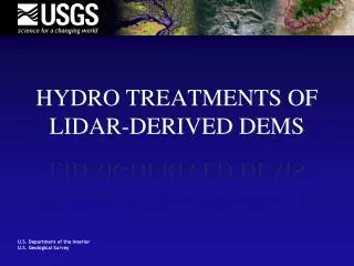
Hydro-Flattened DEM Example Lidaronly Hydro-flattened Lidar
Deliverables • Metadata • Raw point cloud • Classified point cloud • Edited LAS file that was used to produce the hydro-flattened DEM • Bare Earth DEM • 3 meter Cell size, 32-bit floating point raster (ERDAS .IMG preferred) • polylineZ and polygonZbreaklinesshapefiles
Open Source Software/Tools • Tools were evaluated for: • Ability to read/write native LAS format • Geoprocessing/data manipulation Capabilities (i.e. – interpolation, raster analysis) • Vector digitizing capabilities (2D) • Scripting or programmability (Access to 3D geometries) • Tools researched were: • lasTools, GRASS, Quantum GIS and gvSIG
LASTools • Suite of 12 command line tools that are able to read from and write to LAS formats • Key tools • Parse and write the LAS header to text • Convert from LAS to ASCII text • Convert from shapefile to LAS • Combine LAS files • Create TINs/DEMs • Thinning algorithm • Not a GIS, but could be used in conjunction with one to help meet specifications
GRASS v6.4 • Geographical Resources Analysis Support System • Originally developed by the U.S. Army Corps of Engineers Construction Engineering Research Laboratories • Is raster and vector GIS combined with image processing and data visualization • Core has 350 modules for management, processing, analysis, and visualization of georeferenced data.
GRASS – continued • Modules are accessible from a Command Line Interface (CLI) or through the wxPython GUI interface • GRASS 6 is written in ANSI C programming language with a few UNIX and PERL scripts • The CLI provides scripting ability from various languages: PERL, Python, Ruby, and Tcl/Tk
GRASS Evaluation • No tools/modules provided for lidar LAS format – can convert from xyz text to vector or raster for analysis • Current version does not have tools for digitizing features • Well developed set of geoprocessing tools for existing data manipulation or raster creation • Scripting ability provides access to streamline manual processes • Requires tools for vector creation and manipulation of LAS files to be utilized towards meeting specifications
Quantum GIS (QGIS) v1.5 • Started in 2002 to build a GIS data viewer on Linux • Best known for it’s support of large amount of data types(both vector and raster through GDAL and OGR libraries) • Ability to edit vector shapes and attribute tables through a GUI • Provides tools that allow for heads up digitizing
QGIS – continued • Written in C++ • Provided Command Line Interface gives access to scripting ability through Python
QGIS Evaluation • No tools/modules provided for lidar LAS format – can convert from xyz text to vector or raster for analysis • Vector support is limited to 2D extraction • Access to GRASS modules provided through an established Plugin • Could be customized with Python scripts or through GUI
gvSIG v1.1.2 with DielmoLidarExtension v 2 • Began in 2004 within a project to migrate the information technology systems of the Regional Ministry of Infrastructure and Transport of Valencia, Spain to free software • Support for common data formats • Ability to display local and remote data in the same view • Ability to edit vector data and attributes through a GUI
gvSIG - continued • Geoprocessing tools provided within an extension called Sextante • Written in Java • Best known for being designed to be easily extendable and enabling tailor-made solutions
gvSIGDielmoLidarExtension Evaluation • Vector support limited to 2D extraction • DielmoLidarExtension provides tools for lidar within gvSIG • Ability to read/write/edit native LAS • Extension has built-in QA/QC tools for lidar • Flight lines • Control points • Translations to English not fully complete • Customizable using Java programming
Summary • Defined Open Source Software • Outlined Product Specifications and deliverables for USGS • Identified Open Source Tools • lasTools • GRASS • gvSIG with DielmoLidarExtension
Conclusion • The package that provides the tools required for meeting the specifications outlined by the USGS is gvSIG. • Customized tools within gvSIG could potentially be developed to: • Provide access to the Z value of the shapefiles in order to be populated • Streamline geoprocessing tools into a GUI • lasTools, QGIS and GRASS could be used in conjunction to meet specifications.
Conclusion – continued • Creation of a custom breakline tool is vital to meeting the specifications for shapefiles • Currently reviewing the object models of gvSIG and QGIS to find out which one can provide access to populate the z-value of the shapefile geometry • Decision of which program to code for and in what language needs to be made • Milestones need to be established(i.e. – providing the capability to digitize a lake with constant elevations)