Global Positioning System-GPS
Global Positioning System-GPS. Satellite Laser Ranging-SLR.
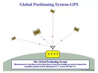

Global Positioning System-GPS
E N D
Presentation Transcript
Satellite Laser Ranging-SLR In Satellite Laser Ranging (SLR) a global network of stations measure the instantaneous round trip time of flight of pulses of light to satellites equipped with special reflectors. This provides instantaneous range measurements of horizontal and vertical station motions on a global scale in a geocentric reference frame of mm/yr level precision. The height of the geoid has been determined to less than ten cm at long wavelengths less than 1500 km. Thirty-second mean gravity anomalies from the EGM96 model show the fine detail.
Very Long Baseline Interferometry-VLBI VLBI(Very Long Baseline Interferometry) is a geometric technique: it measures the time difference between the arrival at two Earth-based antennas of a radio wavefront emitted by a distant quasar.VLBI determines the relative positions of the antennas to a few millimetersprecision.
Interpretation of Space Geodesy Data VLBI consists of a pair of receivers, at different locations on the Earth, looking at the same quasar. When two receivers are oriented facing a quasar, receiver A will receive a code before receiver B. Using the time delay, the distance between the two stations can be determined. Now, at a later time, when station A is again oriented with respect to the quasar as before, if B has moved so that it is closer to A the delay time between the reception of a code will be less than before. But,if the distance between receivers A and B has remained fixed but the Earth has expanded in the mean time, this, due to curvature reduction, would also reduce the delay time between the two receivers. SLR consists of beaming lasers toward satellitesand provides independent but similar measurements to VLBI, with the same ambiguity as to whether there has been surface horizontal movement, orEarth expansion.
S S S΄ A A A B d B΄ R D R B B R΄ (a) (b) (c) Surface Movement or Earth Expansion? (B. Mundy) R: the radius,R, of the unexpanded earth, the same in (a) and (b); S: the arc length, S, between stations A and B, the same in (a) and (c),; D: the long time delay D could be the same in (a) and (b) in a constant size Earth if there is no arc length shortening, that is no horizontal converging of plates. d: the short time delay d could be the same in (b) and (c), as a result of the reduction of distance ABby BB΄, that is reduction of arc length to S΄, in a constant size Earth, due to converging plates on the small radius R 1, or to the reduction of curvature, on a bigger Earth, with radius R΄2R.
A S21,44 S11,57 h10.293 A ~525 km h20.129 A C1,2 1,41 B θ1=900 R1=1 B R2=2R1 B R1 3200 km R2 6400 km θ241.40 200 m.y.a. – 0 m.y.a. Subsidence rate : expansion rate 1 : 6.1 Convergence rate : expansion rate 1 : 7.7 Earth Expansion and Space Geodesy The cord lengthC1=2R1sin(θ1/2)1.414R1, of a central angle, θ1=900 in a R1=1 circle, is equal to the cord length C2that corresponds to θ2 41.40 in a R2=2R1 circle. On the other hand, in R1=1, and θ1=900 the arc length, S1rad(900)R1 1.57R1 and the segmentheight, h1=R1-[R12-(C/2)2]1/2 0.293R1, while for θ2 41.40 and R2 = 2R1, S2rad(41.40)2R1 1.44R1, and h20.129R1. Thus in an Earth in which its radius has doubled the last 200 m.y., that is an average radius increase of ~1.6 cm/yr, the central continental points will appear to subside, by ~2.6 mm per year, while stations A and B, that are ~4500 km apart, will appear to converge by ~2.1 mm / yr, both to small to be accurately detected.
A-B, D-E, A-E: Lengthening, Primary Global Extension B-C, C-D, B-D: Shortening, Secondary Surface Compression A-D, B-E: No Apparent Change Exaggeration, beyond the few mm/yr, of divergence or convergence between two stations, usually associated with décollement, depends on the position of the stations relative to localextensional or compressional surface features. Also episodic events such as earthquakes, can result to high uplift rates. In the 17 Aug 1999, Izmit 7.4 earthquake, a co-seismic uplift of ~75 cm has been measuredbetween two radar acquisitions on 13 Aug & 17 Sep 1999. The Local Exaggeration of Space Geodesy Data
VLBI Vertical Data In an expanding Earth the vertical motions do not measure radius increase, but the effect of reduced curvature, which means apparent subsidence rates in the range of mm/yr. Indeed the nine (9) out of ten (10) values of vertical motions in western U.S.A. are negative, and the average absolute value is ~2.9 2.5 mm/yr. The negative vertical motions are attributed to the symmetric-chaotic deposition of excess mass, and describe the spheroidal surface, while the positive vertical motions are manifestation of the asymmetric-concentrated emplacement of excess mass, which is responsible for the positive geoidal anomalies. http://lupus.gsfc.nasa.gov/plots/maps/jpg/
VLBI Horizontal Data 1 http://lupus.gsfc.nasa.gov/plots/maps/jpg/ As it can be seen horizontal velocities vary from ~10 mm/yr to a max of ~70 mm/yr showing Hawaii moving towards Asia. Hawaii moving towards Asia is a typical example of exaggerated local control. Since Hawaii is located on an extensional and domed feature, then a station facing another station will move toward it faster than ‘normal’.
http://lupus.gsfc.nasa.gov/plots/maps/jpg/ VLBI Horizontal Data 2 Space geodesy data although still ambiguous, due to accuracy problems (errors are in the order of few mm, at least) and to local exaggeration of relative motions, a) signify local small scale movements, b) differ significantly from the supposed plate motions, and c) are consistent with size increase of the Earth.