GPS (GLOBAL POSITIONING SYSTEM)
GPS (GLOBAL POSITIONING SYSTEM). GROUP – 3 RAJA PUTERI SAFIAH RAJA MUHAIYATDIN AIN NABILA AZIZAN TAN YUH YAN NURUL ATIQAH JAMIN NABILAH NAPI MUHAMMAD HAFIZI AZIZAN. Overview…. What is the GPS actually??. Fully-functional satellite navigation system Orbiting navigational satellites

GPS (GLOBAL POSITIONING SYSTEM)
E N D
Presentation Transcript
GPS(GLOBAL POSITIONING SYSTEM) GROUP – 3 RAJA PUTERI SAFIAH RAJA MUHAIYATDIN AIN NABILA AZIZAN TAN YUH YAN NURUL ATIQAH JAMIN NABILAH NAPI MUHAMMAD HAFIZI AZIZAN
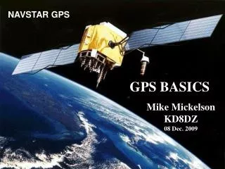
What is the GPS actually?? • Fully-functional satellite navigation system • Orbiting navigational satellites • Transmit position and time data • Handheld receivers calculate • latitude • longitude • altitude • Velocity
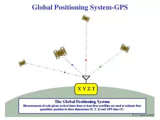
Cont’d • GPS provides specially coded satellite signals that can be processed in a GPS receiver, enabling the receiver to compute position, velocity and time. • At least 4 satellites are used to estimate 4 quantities: • position in 3-D (X, Y, Z) • GPS time (T)
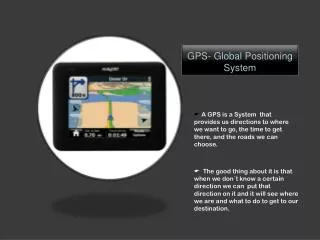
What GPS provide?? • 3D position • Navigation information • position • heading • velocity • Time
Determining Position • A GPS receiver "knows" the location of the satellites. By estimating how far away a satellite is, the receiver also "knows" it is located somewhere on the surface of an imaginary sphere centered at the satellite. It then determines the sizes of several spheres, one for each satellite. The receiver is located where these spheres intersect.
GPS Functionality GPS systems are made up of 3 segments :- • Space Segment (SS) • Control Segment (CS) • User Segments (US)
Three Segments of the GPS Space Segment User Segment Control Segment GroundAntennas Monitor Stations Master Station
Space Segments • Composed 24 to 32 satellites . • The Earth in 6 orbital planes. • Oriented at an angle of 55 degrees to the equator. • The nominal circular orbit is 20,200-kilometer (10,900 nautical miles) altitude. • Completes one earth orbit every 12 hours (two orbits every 24 hours). • Orbital speed of about 1.8 miles per second.
Each satellite has a design life of approximately 10 years, weighs about 2,000 pounds, and is about 17 feet across with its solar panels extended. • Older satellites, ~ designated Block II/IIA ~ still functioning ~ 2 cesium & 2 rubidium atomic clocks • Newer satellites, ~ designated Block IIR ~ rubidium atomic clocks • Contain 3 nickel-cadmium batteries.
Each satellite transmits as part of its signal to ground stations and all users the following information: -Coded ranging signals (radio transmission time signals that allow receivers to triangulate their positions). -Ephemeris position information (a message transmitted every 30 seconds containing precise information on the location of the satellite in space). -Atmospheric data (necessary to help correct signal interference from the satellites to the receiver). -Clock correction information defining the precise time of satellite signal transmission (in GPS Time), and a correction parameter to convert GPS Time to UTC.
Master Control Station Monitor Station Ground Antenna Control Segment US Space Command Cape Canaveral Hawaii Kwajalein Atoll Diego Garcia Ascension Is.
a) Master Control Station (MSC) • The Consolidated Satellite Operations Center. • Located at the US Air Force Space Command Center at Schriever Air Force Base (formerly Falcon AFB) in Colorado Springs, Colorado. • For satellite control and overall system operations.
b) Monitor Stations (MS) Continuously receive GPS satellite transmission The Master Control Station in Colorado information
have 6 monitor stations • These stations are unmanned remote sensors that passively collect raw satellite signal data and re-transmit it in real time to the MCS for evaluation. • Function :- ~ very precise radio receivers ~ tracking each satellite as it comes into view
c) Ground Antennas • Remotely controlled by the MCS. • Have three ground antennas. • located at Ascension, Diego Garcia, Kwajalein Atoll, as well as Cape Canaveral, Florida. • Ground antennas transmit data commands received from the Master Control Station to GPS satellites within their sky view. They also collect telemetry data (the transmission of data from space vehicles to receiving stations on the ground) from the satellites.
Control segment UPLOADNAVIGATIONMESSAGE TRACK Master Control Station Ground Control Station Monitor Station Ground Control Station Monitor Station Ground Control Station Monitor Station
User Segments • The user's GPS receiver is the US of the GPS system. • GPS receivers are generally composed of an antenna, tuned to the frequencies transmitted by the satellites, receiver-processors, and a highly-stable clock, commonly a crystal oscillator). • They can also include a display for showing location and speed information to the user. • A receiver is often described by its number of channels this signifies how many satellites it can monitor simultaneously. As of recent, receivers usually have between twelve and twenty channels.
Using the RTCM SC-104 format, GPS receivers may include an input for differential corrections. • This is typically in the form of a RS-232 port at 4,800 bps speed. Data is actually sent at a much lower rate, which limits the accuracy of the signal sent using RTCM. • Receivers with internal DGPS receivers are able to outclass those using external RTCM data.
Military. • Search and rescue. • Disaster relief. • Surveying. • Marine, aeronautical and terrestrial navigation. • Remote controlled vehicle and robot guidance. • Satellite positioning and tracking. • Shipping. • Geographic Information Systems (GIS). • Recreation.
Parts of GPS The three parts of GPS are: Satellites Receivers Software
a) Satellites There are quite a number of satellites out there in space. They are used for a wide range of purposes: satellite TV, cellular phones, military purposes and etc. Satellites can also be used by GPS receivers.
b) GPS Satellites The GPS Operational Constellation consists of 24 satellites that orbit the Earth in very precise orbits twice a day. GPS satellites emit continuous navigation signals.
c) GPS Signals Each GPS satellite transmits data that indicates its location and the current time. All GPS satellites synchronize operations so that these repeating signals are transmitted at the same instant. Physically the signal is just a complicated digital code, or in other words, a complicated sequence of “on” and “off” pulses.
Four Basic Functions of GPS • Position and coordinates. • The distance and direction between any two waypoints, or a position and a waypoint. • Travel progress reports. • Accurate time measurement.
Satellite ranging • Satellite locations • Satellite to user distance • Need four satellites to determine position • Distance measurement • Radio signal traveling at speed of light • Measure time from satellite to user • Low-tech simulation
Pseudo-Random Code • Complex signal • Unique to each satellite • All satellites use same frequency • “Amplified” by information theory • Economical
Distance to a satellite is determined by measuring how long a radio signal takes to reach us from that satellite. • To make the measurement we assume that both the satellite and our receiver are generating the same pseudo-random codes at exactly the same time. • By comparing how late the satellite's pseudo-random code appears compared to our receiver's code, we determine how long it took to reach us. • Multiply that travel time by the speed of light and you've got distance. • High-tech simulation
Accurate timing is the key to measuring distance to satellites. • Satellites are accurate because they have four atomic clocks ($100,000 each) on board. • Receiver clocks don't have to be too accurate because an extra satellite range measurement can remove errors.
To use the satellites as references for range measurements we need to know exactly where they are. • GPS satellites are so high up their orbits are very predictable. • All GPS receivers have an almanac programmed into their computers that tells them where in the sky each satellite is, moment by moment. • Minor variations in their orbits are measured by the Department of Defense. • The error information is sent to the satellites, to be transmitted along with the timing signals.
Precise Positioning System SYSTEM PERFORMANCE Standard Positioning System • 22 meters horizontal accuracy • 27.7 meters vertical accuracy • Designed for military use 100 meters horizontal accuracy 156 meters vertical accuracy Designed for civilian use No user fee or restrictions
The earth's ionosphere and atmosphere cause delays in the GPS signal that translate into position errors. • Some errors can be factored out using mathematics and modeling. • The configuration of the satellites in the sky can magnify other errors. • Differential GPS can reduce errors.
Frequencies L1 (1575.42 MHz) → Mix of Navigation Message, coarse- acquisition (C/A) code and encrypted precision P(Y) code. L2 (1227.60 MHz) → P(Y) code, plus the new L2C code on the Block IIR-M and newer satellites.
Frequencies (cont’d) • L3 (1381.05 MHz) → Used by the Defense Support Program to signal detection of missile launches, nuclear detonations, and other applications. • L4 (1379.913 MHz) → Being studied for additional correction to the part of the atmosphere that is ionized by solar radiation.
Frequencies (cont’d) • L5 (1176.45 MHz) → To be used as a civilian safety-of-life (SoL) signal. • Internationally protected range for aeronautical navigation. • The first satellite that using this signal to be launched in 2008.
Accuracy • GPS is a "constellation" of at least 24 well-spaced satellites that orbit the Earth and make it possible for people with ground receivers to pinpoint their geographic location. • The location accuracy is anywhere from 1 to 100 meters depending on the type of equipment used. • In coming years, it reduce into 1cm with DGPS( which eliminates selective availability (SA) and provides a much more accurate determination of time and position).
Factors Influencing Position Accuracy • The system errors that are occurring during the time the receiver is operating. → The GPS system has several errors that have the potential to reduce the accuracy. → To achieve high levels of precision, differential GPS must be used.
Factors Influencing Position Accuracy • Differential GPS uses one unit at a known location and a rover. → The stationary unit compares its calculated GPS location with the actual location and computes the error. → The rover data is adjusted for the error. • Real Time Kinematic (RTK) • Post processing
Factors Influencing Position Accuracy The number of satellites (channels) the receiver can track. The number of channels a receiver has is part of it’s design. The higher the number of channels, the greater the potential accuracy. The higher the number of channels, the greater the cost.
Applications: • GPS has different uses such as: • Military • Navigation • Mobile satellite communication • Location based services • Surveying • agriculture
Applications – Military • Military GPS user equipment has been integrated into: • fighters, bombers, tankers, helicopters, ships, submarines, tanks, jeeps, and soldiers' equipment. • To basic navigation activities, military applications of GPS include • target designation of cruise missiles • precision-guided weapons • close air support • To prevent GPS interception by the enemy, the government controls GPS receiver exports • GPS satellites also can contain nuclear detonation detectors.
Applications – Civilian • Automobiles are often need GPS receivers. • Show moving maps • Give information about your position on the map • Speed you are traveling • High of buildings • exits etc.
Applications – Civilian (cont’d) • Agriculture • GPS provides: • precision soil sampling, data collection, and data analysis, enable localized variation of chemical applications and planting density to suit specific areas of the field. • Ability to work: • in low visibility field conditions such as rain, dust, fog and darkness increases productivity. • Accurately monitored yield data enables future site-specific field preparation.