Download
1 / 8
80 likes | 106 Vues
Join the National Geospatial Advisory Committee in shaping a strategy for cohesive geospatial data management and dissemination. Discussing roles, partnerships, and activities towards empowering our nation.

E N D
NGAC Discussion – Toward a National Geospatial Strategy June 4, 2008 National Geospatial Advisory Committee
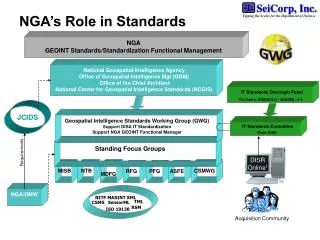
NGAC Purpose & Mission • Scope & Objectives (from NGAC Charter): • The Committee will provide advice and recommendations related to management of Federal and national geospatial programs, the development of the NSDI, and the implementation of OMB Circular A-16 and Executive Order 12906. The Committee will review and comment upon geospatial policy and management issues and will provide a forum to convey views representative of non-federal stakeholders in the geospatial community. • NGAC Mission Statement (as adopted by NGAC 6-3-08): • To provide strategies regarding the creation, management and dissemination of cohesive geospatial data, information and knowledge to enable commercial, academic, and nonprofit organizations and all levels of government to more effectively: • empower and serve the public • protect our homeland • foster economic growth • advance science • manage our resources • prepare for and respond to emergencies • govern our nation National Geospatial Advisory Committee
NGAC Guidance Memorandum Initial Focus Areas/Issues 1. Advancing the National Spatial Data Infrastructure • NSDI - Future Roles and Responsibilities of Key Players 2. Public-Private Partnerships • Investment Strategy 3. Management of Federal Geospatial Resources • OMB Circular A-16 4. Data Initiatives • Imagery for the Nation • The National Map • National Land Parcel Data National Geospatial Advisory Committee
NGAC Activities • Short-term (present to 06/08) • Approval of NGAC Mission Statement • Feedback & Recommendations on IFTN • Medium-term (present to 12/31/08) • Changing Landscape White Paper • Transition Strategy with recommendations • Feedback on upcoming Geospatial LoB Products • Feedback the National Land Parcel Study • Feedback on TNM Strategic Plan National Geospatial Advisory Committee
NGAC Activities • Longer-term Activities (12-18 months): • Development of a National Geospatial Strategy, including: • Desired Future State • Functional requirements of the system • Public-Private Partnership/Investment Strategy • Organizational framework and governance responsibilities National Geospatial Advisory Committee
Components of the NSDI: A working framework for activities of the NGAC National Geospatial Advisory Committee
NGAC National Geospatial Strategy Discussion • Changing Landscape White PaperStatus Report • Visioning Subgroup Report • Organizational Design Subgroup Report • Discussion / Next Steps National Geospatial Advisory Committee
NGAC National Geospatial Strategy Discussion • “Changing Landscape” White PaperStatus Report • “Visioning” Subgroup Report • Organizational Design Subgroup Report • Discussion / Next Steps National Geospatial Advisory Committee