Identifying Sensitive Aquifers in Ohio: Insights and Data Analysis
200 likes | 368 Vues
This study, conducted by Chris Kenah, Michael W. Slattery, Linda D. Slattery, and Michael Eggert from the Ohio EPA, focuses on identifying sensitive aquifers in Ohio using various data analyses. Key topics include the logic behind sensitive aquifer identification, water quality data, impacted public water systems (PWSs), and the analysis of glacial aquifer locations. The research discusses recharge pathways, geological settings, and evaluates compliance data in relation to water quality impacts on sensitive aquifers. This research aims to improve understanding and management of Ohio's groundwater resources.

Identifying Sensitive Aquifers in Ohio: Insights and Data Analysis
E N D
Presentation Transcript
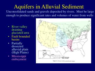
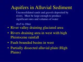
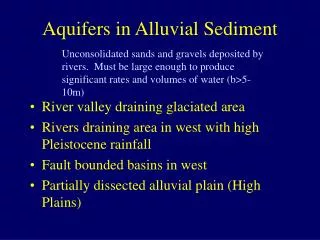
Identifying Sensitive Aquifers in Ohio Chris Kenah, Michael. W. Slattery, Linda. D. Slattery, and Michael Eggert Ohio EPA, Division of Drinking and Ground Waters DMT’06
Outline • Logic for identifying sensitive aquifers • Suspected sensitive aquifers • Water Quality/SWAP data - Impacted PWSs • Analysis of ODNR glacial aquifer attributes and location of impacted PWSs • Differences between geologic setting and lithologic attributes • Ohio Sensitive Aquifers
Data Sources • Geologic Information • Recharge Pathways • ODNR Aquifer Maps • PWS Compliance and Ambient Data • Nitrate, VOC, SOC • Special Study Knowledge
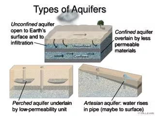
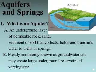
Logic for Sensitive Aquifer ID • Short or Rapid Recharge Pathways • Areas of Ground Water - Surface Water Interaction • Recharge through Glacial Drift • Identify glacial settings with rapid recharge
Sensitive Glacial Settings • Buried Valleys - sand & gravel aquifers • Fine to coarse grained material • Buried valley, alluvial, out wash/kame, and beach ridge geologic settings • Thin Glacial Drift - over bedrock aquifers • Fined grained - tills and lacustrine deposits • Lacustrine, ground and end moraine settings
Ohio SWAP Program • SWAP Susceptibility Analysis • Includes evaluation of compliance data; • 516 PWSs Highly Susceptible • Based on water quality compliance data • Nitrate > 2.0 mg/L • VOC or SVOC detections
WQ Impacts in Sensitive Aquifers? • Attach glacial aquifer attributes to PWS locations • Evaluate PWS WQ impact association with: • Glacial geologic settings • Glacial lithologies • Compare percentage of PWSs impacted
Data Limitations • ODNR aquifer maps thickness are ranges not well depths • If glacial drift < 25’, bedrock production well likely • If glacial drift > 25’, production may be in drift • In thicker glacial sand and gravels, well depth may not approach glacial drift thickness • In thicker till lithologies, production may come from sand lenses or bedrock • Utilizing statewide generalizations
Sensitive Aquifers • PWSs with WQ impacts associated with: • Coarse S&G aquifers • Thin Tills (0-25 ‘) • Aquifers composed of fines provide more protection than S&G aquifers and thin tills over bedrock aquifers; • Thick tills are associated with low % of PWSs with WQ impacts (3-4 %)
Future Activities - Sensitive Aquifers • Attach glacial drift thickness, DRASTIC ranking, and soil properties to PWS locations for analysis of WQ impacts • Incorporate well casing length and depth as analysis factors • Evaluate dissolved vs particulate sensitivity • Identify areas where horizontal flow pro-vides rapid recharge • Short term sampling in sensitive aquifers
Acknowledgments • Data: • Ohio EPA Staff • PWS Operators • ODNR Aquifer Map • GIS Support: • Ohio EPA, DDAGW GIS Unit