Download
1 / 21
270 likes | 585 Vues
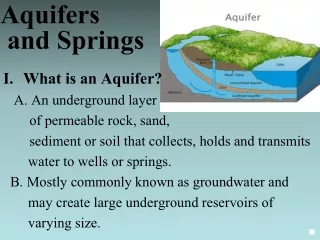
Groundwater and Aquifers. Groundwater Hydraulics Daene C. McKinney. Some Terminology. Hydrology ( ) - “water”; - “study of” Study of Water : properties, distribution, and effects on the Earth’s surface, soil, and atmosphere Water Management

E N D
Groundwater and Aquifers Groundwater Hydraulics Daene C. McKinney
Some Terminology • Hydrology () • - “water”; - “study of” • Study of Water: properties, distribution, and effects on the Earth’s surface, soil, and atmosphere • Water Management • Sustainable use of water resources • Manipulating the hydrologic cycle • Hydraulic structures, water supply, water treatment, wastewater treatment & disposal, irrigation, hydropower generation, flood control, etc.
Some History • Qanats • Subterranean tunnels used to tap and transport groundwater • Originally in Persia • Kilometers in length • Up to 3000 years old • Many still operating • Chinese Salt Wells • 1000 years ago: Drilled wells • Over 300 meters deep • Bamboo to retrieve cuttings • By year 1858: 1000 meters deep • Called “cable tool” drilling today Ancient Persian Qanat Ancient Chinese Salt Well
Old Theories • Homer (~1000 BC) • “from whom all rivers are and the entire sea and all springs and all deep wells have their waters” • Seneca (3 BC -65 AD) • “You may be quite sure that it not mere rainwater that is carried down into our greatest rivers.” • DaVinci (1452-1519) • accurate representation of the hydrologic cycle • Descartes (1596-1650) • Vapors are drawn up from the earth and condensed… • Kircher(1615-1680) • Water from the ocean is vaporized by the hot earth, rises, and condenses inside mountains.
Old Theories (Cont.) • Vitruvius (~80-20 BC) • 8th Book on Water and Aqueducts. Rain and snow on land reappears as springs and rivers • Palissy(1509-1590). • French scientist and potter - accurate representation of the hydrologic cycle • Perrault (1670): • Water balance on the Seine. River flow explained by rainfall. • Mariotte(1620-1684). • French physicist. First recharge estimates. Leaky roof analogy. • Vallisnieri(1723) • At lower altitudes in the Alps, artesian wells are common. Higher altitudes in Alps, streams are losing water Groundwater originates from rain.
Modern Theories • Henri Darcy (1856) • Relationship for the flow through sand filters. Resistance of flow through aquifers. Solution for unsteady flow. • King (1899) • Water table maps, groundwater flow, cross-section • Hazen, Slichter, O. E. Meinzer(1900s) • Practical applications, basing on theoretical principles of French hydrogeology • C.V. Theis(1930s) • Well Hydraulics Henri Darcy C.V. Theis
2.5% OF TOTAL GLOBAL (Freshwater) 68.9% Glaciers & Permanent Snow Cover TOTAL GLOBAL (Water) 29.9% Fresh Ground water 97.5% Salt Water 0.3% Freshwater Lakes & River Storage. Only this portion is renewable 0.9% Other including soil moisture, swamp water and permafrost Global Water Resources Groundwater Management in IWRM: Training Manual, GW-MATE, 2010
Principal sources of fresh water for human activities (44,800 km3/yr) Global Water Cycle Residence time: Average travel time for water through a subsystem of the hydrologic cycle Tr = S/Q Storage/flowrate
Hydrologic Cycle (Local view) Atmospheric Moisture Rain Snow Evaporation Interception Energy Throughfall and Stem Flow Snowpack Snowmelt Watershed Boundary Pervious Impervious Surface Infiltration Our focus Evapotranspiration Soil Moisture Percolation Overland Flow Groundwater Groundwater Flow Evaporation Streams and Lakes Channel Flow Runoff
Major Aquifers of Texas Ogallala Edwards
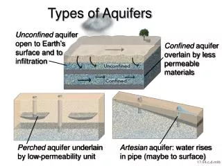
Edwards Aquifer • Primary geologic unit is Edwards Limestone • One of the most permeable and productive aquifers in the U.S. • The aquifer occurs in 3 distinct segments: • Contributing zone • Recharge zone • Artesianzone
Contributing Zone of Edwards Aquifer • Located north and west of the aquifer in the region referred to as the Edwards Plateau or Texas Hill Country • Largest part of the aquifer spanning 4400 sq. miles • Water in this region travels to recharge zone
Recharge Zone of Edwards Aquifer • Geologically known as the Balcones fault zone • It consists of an abundance of Edwards Limestone that is exposed at the surface • -provides path for water to reach the artesian zone
Artesian Zone of Edwards Aquifer • The artesian zone is a complex system of interconnected voids varying from microscopic pores to open caverns • Located between two relatively less permeable layers that confine and pressurize the system • Underlies 2100 square miles of land
The Ogallala Aquifer • Approximately 170,000 wells draw water from the aquifer. • Water level declines of 2-3 feet per year in some regions . • Only 10% is restored by rainfall.
The Ogallala Aquifer Water Level Change up to 1980 Water Level Change 1980 - 1994
Summary • Course Introduction and Housekeeping • Groundwater and Aqufiers • Terminology • History • Global Water Resources • Global Water Cycle • Texas Aquifers • Edwards • Ogallala