Download

1 / 24
300 likes | 823 Vues
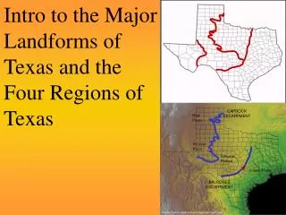
Four Major Regions of Texas. High Plains Region. North Central Plains Region. Coastal Plains Region. Mountains & Basins Region. Gulf Coastal Plains. Location Borders Mexico in the south Borders the Red River in the north West borders the Balcones Escarpment

E N D
High Plains Region North Central Plains Region Coastal Plains Region Mountains & Basins Region
Gulf Coastal Plains • Location • Borders Mexico in the south • Borders the Red River in the north • West borders the Balcones Escarpment • Louisiana borders the east.
Gulf Coastal Plains • Climate/Weather • Warm in the South • Cold in the North • More rain and violent storms than any other region – hurricanes and tornadoes. • 30-55 inches of rainfall a year
Gulf Coastal Plains • Plant/Animal Life • Opossum • Alligator • Fish • Squirrels • Rabbits • Shrimp • Coyote • Pine trees • Tall grasses • Palm Trees
Gulf Coastal Plains • Main Agriculture • Timber, dairy, cattle, hogs, poultry, grain sorghum, cotton, corn, peanuts, roses, fruits, hay, fish, sheep, wheat, vegetables, rice, citrus, and shrimp • Natural Resources • People, lots of rain, rivers, trees and paper mills, chemical plants, ports, and oil
Coastal Plains • Major Cities • Austin • Brownsville • Dallas • Houston • San Antonio • Tyler Dallas Tyler Austin Houston San Antonio Houston is 3rd largest seaport & is connected to roads, railroads, and airlines Gulf Intracoastal Waterway Brownsville
North Central Plains • Location • Climate/Weather • Main Agriculture • Other Resources • Major Cities
North Central Plains • Location/Landforms • Center part of the state • Hill Country in the southern part • Bordered by the Cap Rock Escarpment on the west • Bordered by the Balcones Escarpment on the east • Rolling hills, caves, plains and mesas.
North Central Plains • Climate/Weather • Cold winters • Hottest summer temperatures in the state • 20-30 inches of rainfall a year • Violent storms and tornadoes
North Central Plains • Main Agriculture • Cattle, goats, sheep, cotton, grain sorghum, oats, pecans, hay, peaches, cedar trees, wheat, corn, peanuts • Other Resources • Fertile soil, beef, wool, mohair from angora goats, oil in some areas
Plant/Animal Life • Bald Eagle • Horned Lizard • White-tailed deer • Armadillo • Mesquite Trees • Bluebonnets
North Central Plains • Major Cities • Abilene • San Angelo • Fredericksburg • Waco • Wichita Falls • Fort Worth Wichita Falls Abilene Waco San Angelo Fredericksburg
High Plains • Location • Texas Panhandle to the north • Cap Rock Escarpment on the east. • Edwards Plateau • Hills • Plains • cliffs
High Plains • Climate/Weather • Windy • Dry • Very cold in the winter • Very hot in the summer • Coldest region of Texas • 15-20 inches of rainfall a year • Violent sand, snow, and rain storms
Plant & Animal Life • Deer • Lizards • Jackrabbits • Coyote • Mountain lions • Prairie dogs • Burrowing owl • sunflowers
High Plains • Main Agriculture • Wheat, cotton, grain sorghum, corn, cattle, and hay • Other Resources • Fertile soil with the help of irrigation, oil, petroleum, helium and farms
High Plains Amarillo • Major Cities • Amarillo • Lubbock • Midland • Odessa Lubbock Midland Odessa
Mountains and Basins • Location • Pecos River on the east • Mexico on the west • Mountains • Basins • El Capitan • Guadalupe Peak • Chihuahuan Desert
Mountains and Basins • Climate/Weather • Driest area of the state • 0-16 inches of rainfall a year • Warm most of the time • Never stays cold for long
Plant & Animal Life • Snakes • Spiders • Kangaroo rats • Deer • Cactus • Mountains lions • 450 kinds of birds
Mountains and Basins • Main Agriculture • Cattle, dairy, hogs, cotton, wheat, hay, alfalfa, goats, sheep, some fruits and vegetables • Other Resources • Beef cattle ranches, trade with Mexico, Big Bend National Park
El Paso Fort Stockton Alpine Mountains and Basins • Major Cities • Alpine • El Paso • Fort Stockton