Download

1 / 55
550 likes | 588 Vues
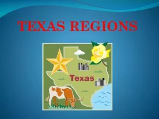
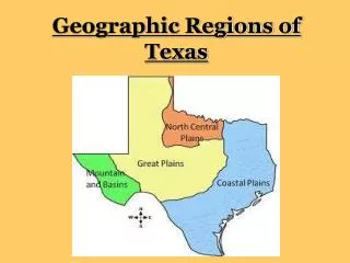
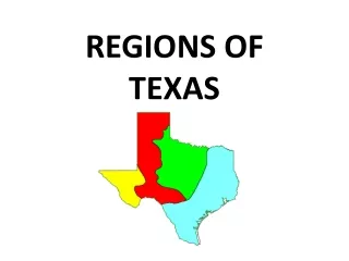
Regions of Texas. 4. How many regions are in Texas ?. Great Plains. North Central Plains. Mountains and Basins. Coastal Plains. What region is Fort Worth in?. NORTH CENTRAL PLAINS. NORTH CENTRAL PLAINS. Location Center part of the state. North Central Plains Cities. Austin

E N D
4 How many regions are in Texas? Great Plains North Central Plains Mountains and Basins Coastal Plains What region is Fort Worth in?
NORTH CENTRAL PLAINS • Location • Center part of the state
North Central PlainsCities • Austin • Waco • Fredericksburg • Llano • Fort Worth • Wichita Falls • Abilene • The Hill Country is a popular name for the area of hills along the Balcones Fault and is a transitional area between the Great Plains and the Gulf Coastal Plains.
North Central PlainsPhysical Features Prairies Forests in the Cross Timbers Rolling Plains and Hills Variety of trees Small shrubs Limestone rock - Thick grass
NORTH CENTRAL PLAINS PHYSICAL FEATURES AFFECT INDUSTRY Rich soils support farm industries
NORTH CENTRAL PLAINSSUBREGIONS This region is divided into 3 subregions: Grand Prairie Cross Timbers Rolling Plains
NORTH CENTRAL PLAINS HAS 3 SUBREGIONS GRAND PRAIRIE – flat and rolling hills, grasslands; suited for livestock CROSS TIMBERS – sandy soil; good for farming a variety of crops ROLLING PLAINS – grasslands; hilly terrain; steep valley; rivers; suited for cattle and ranches
NORTH CENTRAL PLAINSCLIMATE • Sub tropical • Cold winters • Hottest summer temperatures in the state • 20-30 inches of rainfall a year • Violent storms and tornadoes
NORTH CENTRAL PLAINSPLANTS -bluebonnets -Indian Paintbrush -Texas Oak Trees -Mesquite Trees
North Central Plains Animals • Bobcat • White-tailed deer • Turkeys
NORTH CENTRAL PLAINS AGRICULTURE • Cattle, goats, sheep, cotton, grain sorghum, oats, pecans, hay, peaches, cedar trees, wheat, corn, peanuts • Fertile soil, beef, wool, mohair from angora goats, oil in some areas
NORTH CENTRAL PLAINS ECONOMY The fertile soil produces crops for a large portion of its industry
COASTAL PLAINS • largest of the 4 Texas regions
Location of Coastal Plains Covers 1/3 of the land of Texas
COASTAL PLAINS CITIES • Austin • Brownsville • Dallas • Houston • San Antonio • Tyler • Texarkana • Corpus Christi
Coastal PlainsPhysical Features Woods & Forest Beaches Grassy Plains and Prairies Has lots of fishing and shrimping It is the largest of the four regions in Texas Gets the most rainfall
COASTAL PLAINS This region is divided into 5 subregions: Piney Woods Gulf Coastal Plains South Texas Plains Post Oak Belt Black land Prairie
COASTAL PLAINSSUBREGIONS Piney Woods – pine forest, farming, timber Gulf Coast Plain – prairie, bayous, farming, ranching, fishing, ports, oil, petrochemicals South Texas Plains – warm dry climate, year-round farming, ranches Post Oak Belt – sandy soils, prairies, farming, energy resources Blackland Prairie – rich soil, large population, manufacturing
COASTAL PLAINS • Much of the coast of Texas is made up of marshes----wetlands where a variety of tall grasses grow.
COASTAL PLAINS CLIMATE -Hot and damp, humid -Tornadoes, hurricanes “More rain and violent storms than any other region” -30-55 inches of rain per year Warm in the South Cold in the North
COASTAL PLAINS ANIMALS Many kinds of animals live in the coastal plains region… • Quail, Hawks, Owls, Bald Eagles and hundreds of other birds • White tail deer • Foxes, Bobcats, Skunks • River otters • Alligators in the marshes!!! Some weigh up to 500 lbs!!!
COASTAL PLAINSAGRICULTURE • Timber, dairy, cattle, hogs, poultry, grain, sorghum, cotton, corn, peanuts, roses, fruits, hay, fish, sheep, wheat, vegetables, rice, citrus, and shrimp • People, lots of rain, rivers, lumber and paper mills, chemical plants, ports, and oil
COASTAL PLAINS Economy Way of life: fishing, timber, oil and gas The gulf coast is a major center of economic activity. The marshlands provide breeding grounds for ocean life, which make the fish and shrimp businesses very important. The port of Houston is one of the 10 busiest ports in the world.
COASTAL PLAINS • Oil and Gas Along the coastal region you will find many oil rigs that are on-shore and off-shore. The ocean gives easy access to ship the oil and gas to where it needs to go.
THE GULF COAST PLAINS ADAPTS TO ENVIRONMENT Houston – petrochemicals, shipping, manufacturing Dallas – banking, manufacturing, corporate headquarters Laredo – trade, farming San Antonio – tourism, military, retail
GREAT PLAINS • Region is located mostly in the panhandle area of Texas. • This area is very flat with a high elevation that features canyons. It is a barren area with very few trees.
GREAT PLAINSLOCATION • Texas Panhandle to the north • Cap Rock Escarpment on the east -Northeast Texas -Colorado and Red Rivers are the borders.
GREAT PLAINS CITIES -Amarillo -Lubbock -Odessa Abilene Midland -San Angelo -Wichita Falls
PHYSICAL FEATURES OF THE GREAT PLAINS Panhandle area of Texas Highest Elevation in Texas High and flat treeless plains and grasslands Caprock Escarpments with elevation rising to the east Balcones Escarpments along the eastern and western edges Red River forms Palo Duro Canyon Caprock – hard bed of rock below the soil of the High Plains Escarpment – cliffs
GREAT PLAINSGEOGRAPHIC FEATURES -Rolling grassy lands -Thick grasses -Cross Timbers area - large areas of hardwood trees -Limestone rock -Higher elevation because limestone doesn't wear down easily
GREAT PLAINS This region is divided into 3 subregions: High Plains Edwards Plateau Llano Basin
GREAT PLAINS • Climate • Windy, Dry Air • Tornadoes • Very cold in winter • Very hot in summer • Coldest region of Texas • 15-20 inches of rainfall a year • Violent sand, snow, and rain storms
GREAT PLAINS PLANTS -Prickly pear -Yucca -Indian Paintbrush -Cactus
GREAT PLAINS ANIMALS Pronghorn Prarie Dog Snakes Toads
Great Plains Economy Way of Life Cattle ranching and cotton farming are major sources of commerce in this area Farming - fruits, vegetables, watermelons, oats Ranching - cattle, angora goats (mohair) Cedar trees - fenceposts Oil and gas
TEXANS HAVE ADAPTED TO THE ENVIRONMENT OF THE GREAT PLAINS Used grasslands for farming Pumped water for irrigating crops Drilled for oil and gas Built cities
MOUNTAINS AND BASINSLOCATION • Far west Texas • East border near Pecos River • South border is the Rio Grande • North border is New Mexico
MOUNTAINS AND BASINS CITIES • Alpine • El Paso • Fort Stockton - Pecos -Kermit & Monahans in Permian Basin area -Fort Davis, Marfa, & Alpine in Mountain area
MOUNTAINS AND BASINSPHYSICAL FEATURES • Towering Peaks, Rocky Canyons, and flowering cacti. • Mountains and Basins have dry, rocky soils. • Places: Big Bend National Park, Guadalupe National Park, and Davis Mountains
MOUNTAINS AND BASINS • Guadalupe Peak is the highest point in Texas
MOUNTAINS AND BASINS PHYSICAL CHARACTERISTICS Dry desert climate Rocky soil Mountains, Canyons, Basins Plateaus Limited Plant Life
Mountains and BasinsPhysical Features Mountains ranges, basins & plateaus Guadalupe Mountains Big Bend National Park Guadalupe Peak – highest peak in Texas (8749 feet) Basins are lowlands surrounded by higher land.
MOUNTAINS AND BASINS This region has no subregions
MOUNTAINS AND BASINS CLIMATE -Driest part of state -8 inches of rain per year, 20 in mountains -Hot days, cool nights