Download
1 / 18
190 likes | 425 Vues
Discover the Coastal Plains, North Central Plains, Great Plains, and Mountains and Basins regions of Texas. Learn about their unique geography, climate, and vegetation. Dive into the subregions that make each area distinct. Gain insights into Texas's diverse population and economic activities. Explore the rich cultural heritage and natural beauty of the Lone Star State.

E N D
Texas Regions Chapter 2 Texas & Texans pages 46-69 cannibal.mi.org/ ~chad/pic/tx/texas.jpg
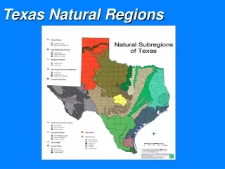
The Four Regions of Texas Natural regions are determined by physical geography features such as landforms, climate, and vegetation. The four regions are: All three of these regions can be divided into subregions (a smaller division of a geographic region) 1. Coastal Plains North Central Plains 2. 3. Great Plains 4. Mountains and Basins
Coastal Plains 1. • Includes about 1/3 of Texas • Home to more people than any other part/region of Texas • About 2 out of every 3 Texans live in the Coastal Plains • WE live in the Coastal plains • The Coastal Plains are divided into 5 subregions: -Piney Woods -Post Oak Belt -Gulf Coast Plain -Blackland Prairie -South Texas Plain
SUBREGIONS OF TEXAS Coastal Plains and its Subregions 1.
North Central Region and its Subregions 2. • Rolling plains lBrush, scattered grasses • Covered by small oak and mesquite trees • North Central Region is divided into 3 subregions: • Grand Prairie • Cross Timbers • Rolling Plains
SUBREGIONS OF TEXAS North Central Region and its Subregions 2.
Great Plains Region and its Subregions 3. Great Plains Region is divided into 3 subregions: 1. Llano Basin: -nearly center of Texas -made up of granite (pink in color) and hard rock that is formed when molten rock cools slowly under the earth’s surface -mesquite, live oak, and post oak trees -short grasses 2. Edwards Plateau: -primarily of limestone -caves and underwater streams -Edwards Aquifer (San Antonio’s water supply) is in this subregion 3. High Plains: -major farming area -dry climate -elevation ranges from 3,000-4,000 feet
Mountains and Basins Region 4. • Tall mountains separated by large basins (closed valleys) • Forests on mountains • Lower elevations (basins) are deserts with cactus, short grasses, and shrubs • Very little rain • Contains the HIGHEST POINT IN TEXAS: • Guadalupe Peak ~ 8,749 feet www.utpb.edu/.../ Links/basin_range.htm www.usa-reise.de/planung/ hdb-guadalupe-mounta...
Texas Regions Summary • Learning to identify different regions in Texas can be difficult. • The Balcones Escarpment is important because it divides the lowest parts of Texas from the higher areas. (East and south are lower and flatter, while the land west of the Balcones Escarpment is more varied.) • The Great Plains is largely an elevated plateau – very flat and contains some deep canyons. • The Mountains and Basins regionis the only area where there are mountain ranges separated by flat-bottomed valleys called basins.
Mapping Texas People • The 2010 census = about 26 million in Texas • Texas = 2nd most populated state (CA is #1) • Although Texas is famous for ranches and oil wells, most Texans don’t live in rural areas – they live in cities. A metropolitan areais a city and the area around it, including the suburbs. (A suburb is a smaller community just outside a city.) Just how populated are Texas metropolitan areas?
Why do cities grow? • Why do so many people live in Central and East Texas and so few in West Texas? • People tend to live where the jobs are. • For example, Houston began to grow in its early years because of its oil industry (the activity of making or preparing products for sale). • Dallas – large number of companies, Dallas/Fort Worth International Airport (one of the busiest airports in the US). • San Antonio – military bases, scenic (Alamo, River Walk) • Austin – Capital, largest university in the state (University of Texas), high-tech industry • NO big industry in West Texas
Farming in Texas • Even though most Texans live in cities, agriculture is still one of the state’s most important industries. • Only the state of California earns more money from farming than Texas. • Texas produces more cotton than any other state. • Other important crops include: peanuts, black-eyed peas, pecans, wheat, potatoes, corn, rice, hay, soybean, and citrus fruit. • Texas is also an important livestock producer – mainly cattle, sheep, and goats.
The Rich and Poor in Texas • Per capita income is often used to measure how wealthy people are. (Per capita income= the average amount of income per person per year in a given area) • If you take all the money earned by everyone in Texas and divide it by the state’s population, you will find the per capita, or per person, income. In 2011, the per capita income was $25,548. • Bigger cities attract well educated people and, therefore, get more high paying jobs. • Sherman County (rich with oil industry) has the highest per capita income. (This is near Oklahoma in the Northern Panhandle.) • The areas around the border of Mexico have the lowest per capita income.
Diverse Names of Texas Cities and Towns • Texas has a number of cities and towns whose names reflect the various people that make up our state. • Many Texas place names are taken from Spanish words that honor a certain place, an individual, or a characteristic of an area. (San Antonio is the largest city in Texas with a Spanish name.) • Many other Texas place names reflect the state’s varied heritage (beliefs and customs that people get from their ancestors). An example of this would be New Braunfels and Fredericksburg and its German heritage.
Today’s Assignment • Issue “Texas Regions Foldable Project Rubric”. Read over the instructions carefully and start working on the “Regions Fact Sheet”. You will have time in class this week to work on this Project. You must also manage your time at home to work on this as well. It is DUE MONDAY 9/16. • NOTE:Unit 1 Test Next Wednesday 9/18.