Enhancing Ground Station Processing with Automated Systems and SQLite-based Hot Spot Analysis
This document outlines enhancements in ground station processing through automation and a relational database (SQLite) to manage requests for known targets. Key features include variable buffer sizes to optimize responsiveness, real-time georectification with good relative accuracy, and the integration of algorithms for normalized difference reflectance analysis and clustering. The workflow aims to improve processing time for real-time data turnaround while ensuring accurate elevation changes through effective Digital Elevation Models (DEMs) and advanced analytical techniques.

Enhancing Ground Station Processing with Automated Systems and SQLite-based Hot Spot Analysis
E N D
Presentation Transcript
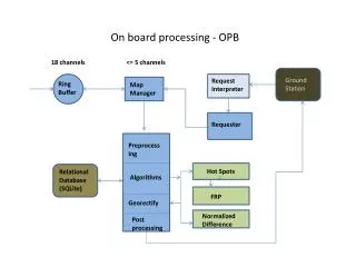
18 channels <= 5 channels Ground Station Request Interpreter Ring Buffer Map Manager On board processing - OPB Requester Preprocessing Hot Spots Relational Database (SQLite) Algorithms FRP Georectify Normalized Difference Post processing
Pre-processing/Product Relationships Multi- Class Shapefile Hot Spots. Temp. DC Radiance Raw data Normalized Difference Reflectance Intermediate FRP Derived Output “Real” Output Scaled Visual Product.
Improvements • Increase automation – ground station front end • Addition of a relational database - currently used to set-up requests for known targets and log requests sent. • Variable buffer size – trade off between responsiveness and histogram variation • “Science” products – FRP, Normalized Difference
Real time georectification Good relative with proper boresighting. Elevation change and importance of a good DEM
Adding Algorithms • Designed with this in mind – fairly easy but does require recompilation • Database (somewhat spatial), meta-data, simple thresholding, normalized differences • Would lend itself well to unsupervised clustering algorithms • Processing time for “real time” turnaround varies with scanrate and buffer size selected. At a scanrate of 11sps, there 1.8 min., to 54sec. of processing time for 1200 and 600 line buffer respectively.