Landforms
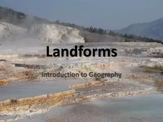
Landforms. Introduction to Geography. In geology, a fault or fault line is a planar fracture in rock in which the rock on one side of the fracture has moved with respect to the rock on the other side. Faults. Landforms associated with faults. Escarpment. Horst.

Landforms
E N D
Presentation Transcript
Landforms Introduction to Geography
In geology, a fault or fault line is a planar fracture in rock in which the rock on one side of the fracture has moved with respect to the rock on the other side.
Landforms associated with faults Escarpment
Graben Fault escarpments GRABEN
Escarpment & Talus Slope • Escarpment: sharp drop-off from a higher elevation to a lower one. It may be called a cliff. • Talus slope: deposited materials at the base of an escarpment – the result of mass wasting . Escarpment Escarpment Talus slopes
The road down the coastal escarpment (Serra da Leba, Angola).