MASS MOVEMENT
MASS MOVEMENT. SETTING OFF A MASS MOVEMENT. TRIGGERING MECHANISMS. NATURAL TRIGGERS. Earthquakes cause liquefaction. Peru, 1970. MASS MOVEMENT. SETTING OFF A MASS MOVEMENT. TRIGGERING MECHANISMS. NATURAL TRIGGERS. Volcanic events induce lahars. Mt. St. Helens, WA 1980. MASS MOVEMENT.


MASS MOVEMENT
E N D
Presentation Transcript
MASS MOVEMENT SETTING OFF A MASS MOVEMENT TRIGGERING MECHANISMS NATURAL TRIGGERS Earthquakes cause liquefaction Peru, 1970
MASS MOVEMENT SETTING OFF A MASS MOVEMENT TRIGGERING MECHANISMS NATURAL TRIGGERS Volcanic events induce lahars. Mt. St. Helens, WA 1980
MASS MOVEMENT SETTING OFF A MASS MOVEMENT TRIGGERING MECHANISMS ANTRHOPOGENIC TRIGGERS Clear-cutting and Forest Fires
MASS MOVEMENT SETTING OFF A MASS MOVEMENT TRIGGERING MECHANISMS ANTRHOPOGENIC TRIGGERS Building on Steep Slopes
MASS MOVEMENT SETTING OFF A MASS MOVEMENT TRIGGERING MECHANISMS ANTRHOPOGENIC TRIGGERS Mining In April 29th, 1903 a disastrous landslide took place at Frank, Alberta. A huge slab of limestone slid from the face of Turtle Mountain and wiped out part of the town. Before Turtle Mountain or “Mountain That Walks”
After 100 seconds later, it was all over. Survivors described a cracking sound like cannon fire echoing throughout the mountains. A 640 metre high, 915 metre wide, 152 metre thick (2,100 feet by 3,000 feet by 500 feet) wedge of the eastern slope of Turtle Mountain gave way and slid 700 metres (2,300 feet) down the mountain side. An estimated 182,000,000,000,000 kg (one hundred million tons) of limestone slid into the valley and onto the town of Frank.
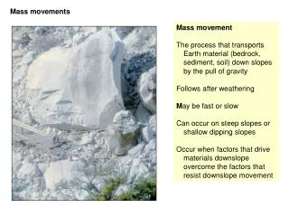
MASS MOVEMENT All mass movements are influenced by weathering and erosion, water, tectonics and biology. Results of mass movement stem from interaction between lithosphere, biosphere, atmosphere and hydrosphere.
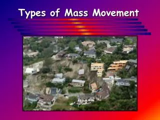
MASS MOVEMENT TYPES OF MASS MOVEMENT SLOW MASS MOVEMENT SURFACE CREEP Slowest form of mass movement. Gradual downslope movement of unconsolidated material. Invokes only upper few meters of sediment. Moves faster at the surface than at depth.
MASS MOVEMENT TYPES OF MASS MOVEMENT SLOW MASS MOVEMENT SURFACE CREEP
MASS MOVEMENT TYPES OF MASS MOVEMENT SLOW MASS MOVEMENT SOLIFLUCTION (SOIL FLOW) Result of movement attributed to freeze-thaw action. Thawed material becomes saturated and can flow.
MASS MOVEMENT TYPES OF MASS MOVEMENT SLOW MASS MOVEMENT SOLIFLUCTION (SOIL FLOW)
MASS MOVEMENT TYPES OF MASS MOVEMENT RAPID MASS MOVEMENT Particles move at rates of km/hr or m/sec. ROCK FALL Fastest type of rapid mass movement. Particles fall from steep slope.
MASS MOVEMENT TYPES OF MASS MOVEMENT Arizona RAPID MASS MOVEMENT ROCK FALL British Columbia
MASS MOVEMENT TYPES OF MASS MOVEMENT RAPID MASS MOVEMENT ROCK SLIDE or LANDSLIDE Occurs when rock, sediment, or unconsolidated material breaks loose and moves in contact with underlying slope along a pre-existing plane of weakness such as a fault, fracture or bedding plane. Plane of weakness is called a SLIP-PLANE. SLIP-PLANE is usually flat or planar. Slide moves in a single, intact mass.
MASS MOVEMENT TYPES OF MASS MOVEMENT RAPID MASS MOVEMENT ROCK SLIDE or LANDSLIDE Gros Ventre Slide Wyoming 1925
MASS MOVEMENT TYPES OF MASS MOVEMENT RAPID MASS MOVEMENT ROCK SLIDE or LANDSLIDE Gros Ventre Slide Wyoming 1925
MASS MOVEMENT TYPES OF MASS MOVEMENT RAPID MASS MOVEMENT SLUMPS A slide that occurs on a curved or concave slip-plane moving in a downward and outward motion. Slumps create their own slip-plane. Usually have a crescent-shape scar at top of slope. Steep slope at the top of the scar is called a scarp. End of the slump is called the toe. Slumps don’t usually travel far.
MASS MOVEMENT TYPES OF MASS MOVEMENT RAPID MASS MOVEMENT SLUMPS
MASS MOVEMENT TYPES OF MASS MOVEMENT CO Rt. 93, Golden, CO RAPID MASS MOVEMENT SLUMPS Rt. 36, Boulder, CO
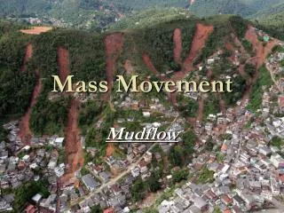
MASS MOVEMENT TYPES OF MASS MOVEMENT RAPID MASS MOVEMENT FLOWS Occurs when a mixture of rock fragments, soil and/or sediment moves downslope as a highly viscous fluid. Flows move rapidly. Dangerous when they have a high water content. Can be related to rainfall.
MASS MOVEMENT TYPES OF MASS MOVEMENT RAPID MASS MOVEMENT FLOWS Earthflow - relatively dry during movement.
MASS MOVEMENT TYPES OF MASS MOVEMENT RAPID MASS MOVEMENT FLOWS Earthflow Slumgullion Slide, western CO 700 yBP
MASS MOVEMENT TYPES OF MASS MOVEMENT RAPID MASS MOVEMENT FLOWS Mudflow - fine-grained particles mixed with water. Mudflow Guatemala, 1989
MASS MOVEMENT TYPES OF MASS MOVEMENT RAPID MASS MOVEMENT FLOWS Quick Clay - ground vibrations liquefy sediments. Quick Clay slide, Rockland, Maine, April 24, 1996
MASS MOVEMENT TYPES OF MASS MOVEMENT RAPID MASS MOVEMENT FLOWS Debris Flow - contains coarser than sand-sized particles. Occurs with a sudden introduction of water.
MASS MOVEMENT TYPES OF MASS MOVEMENT RAPID MASS MOVEMENT FLOWS Debris Flow Revelstoke, BC, Canada
MASS MOVEMENT PREDICTION OF MASS MOVEMENT Study local geology. Consider local historical record. Determine if patterns of mass movement exist. Use 14C, cosmogenic dating, lichenometry, and dendrochronology of older mass movements. Consider animal behavior.
MASS MOVEMENT AVOIDANCE OF MASS MOVEMENT Avoid slide prone areas. Look for signs of historical mass movement. Bent trees Cracks in slope Cuts at base of slope Tilted utility poles Unusually low house prices Check out the neighborhood Read the local newspaper before buying
STREAMS AND FLOODS WATER DISTRIBUTION ON EARTH The amount of water in, on, and above Earth is approximately 1.36 billion cubic kilometers. This amount has been fairly constant over past 1 by.
STREAMS AND FLOODS HYDROLOGIC CYCLE Consider only the surface water component in this chapter.
STREAMS AND FLOODS STREAMS A stream is any surface water whose flow is confined to a channel. Stream and river should be used interchangeably.
STREAMS AND FLOODS FLOODPLAIN A floodplain is any flat land immediately surrounding a stream channel. Floodplains would be submerged if stream overspilled its banks.
STREAMS AND FLOODS DRAINAGE BASIN The drainage basin of a stream is the water-collecting area of a stream.
STREAMS AND FLOODS TRIBUTARIES Tributaries are any smaller streams that feed larger streams within a drainage basin.
STREAMS AND FLOODS DRAINAGE DIVIDE A drainage divide is an area of high topography that separates drainage basins (Rocky Mountains).
STREAMS AND FLOODS STREAM FLOW AND DISCHARGE Flow of any stream is driven by its gradient. GRADIENT is the vertical drop over the course of a stream. Gradient depends upon topography.
STREAMS AND FLOODS STREAM FLOW AND DISCHARGE DISCHARGE is the volume of water passing a given point in a given amount of time. Q = D x W x V
STREAMS AND FLOODS STREAM FLOW AND DISCHARGE
STREAMS AND FLOODS STREAM FLOW AND DISCHARGE Mississippi River discharge = 18,000 cms (600,000 cfs) Amazon River Drains area 75% smaller than U.S. Discharge = 200,000 cms (7,000,000 cfs) = 1/5 of the Earth’s freshwater flow 1 day’s discharge from the Amazon would supply NYC with fresh water for 5 YEARS.
STREAMS AND FLOODS GEOLOGIC WORK OF STREAMS Streams are responsible for erosion and deposition of sediment. Streams cut through uplifted land toward base level. BASE LEVEL is the lowest level to which a stream can erode its channel. Ultimate base level is sea level. Local base levels can occur.
STREAMS AND FLOODS GEOLOGIC WORK OF STREAMS Ultimate Base Level Mississippi Delta, LA Local Base Level Yosemite Falls, CA
STREAMS AND FLOODS GEOLOGIC WORK OF STREAMS Streams can respond to changes in sea level. Erode rapidly downward when sea level falls. Deposit rapidly when sea level rises.
STREAMS AND FLOODS GEOLOGIC WORK OF STREAMS GRADED STREAMS AGGRADATION occurs when deposition is greater than erosion. Aggradation of the Rivière des Ha! Ha! in Quebec
STREAMS AND FLOODS GEOLOGIC WORK OF STREAMS GRADED STREAMS DEGRADATION occurs when erosion is greater than deposition. Broadstreet Hollow Stream, NY
STREAMS AND FLOODS CHANNEL PATTERNS STRAIGHT CHANNELS Channels are dominated by fractures, faults and joints.
STREAMS AND FLOODS CHANNEL PATTERNS BRAIDED CHANNELS Converging and diverging stream channels separated by sand and gravel bars. Usually occur in aggrading streams. Deposit most of their sediment in channel beds.
STREAMS AND FLOODS CHANNEL PATTERNS BRAIDED CHANNELS