Boundary Layer Profiling using various techniques for air quality assessments
180 likes | 337 Vues
Boundary Layer Profiling using various techniques for air quality assessments. Dave DuBois Ilias Kavouras and George Nikolich Division of Atmospheric Sciences Desert Research Institute Las Vegas, NV. Overview of Larger Study.

Boundary Layer Profiling using various techniques for air quality assessments
E N D
Presentation Transcript
Boundary Layer Profilingusing various techniques for air quality assessments Dave DuBois IliasKavourasand George Nikolich Division of Atmospheric Sciences Desert Research Institute Las Vegas, NV
Overview of Larger Study • Study purpose is to measure and interpret air toxics in an urban airshed- Albuquerque, New Mexico • Three air toxics monitoring sites, at existing city stations • Each site measures semi volatile organic compounds, volatile organic compounds, carbonyl compounds and heavy metals • Samples collected in a 1 in 6 day frequency for one year
Overview of Meteorological Study • One objective of the larger study is to determine the impact of meteorological conditions (diurnal, daily, and seasonal time scale) on air toxics concentrations and human exposure • To meet this, we designed a field program with two intensive monitoring periods (IMP) – one in winter (Feb 2008) and one in summer (June 2008)
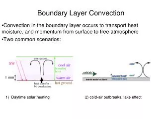
IMP Study Design • Albuquerque is located in a river valley (Rio Grande River runs north-south) in the high desert (elev. 1600 m MSL) • Mountain range immediately to the east of city (peak at 3255 m MSL) • Conceptual model of up/down valley drainage and some up/down slope wind patterns • Measurements focused on capturing diurnal patterns of slope flows and temperature inversions
Typical View of Winter Stagnation North Plaza office tower is 107 m (highest building in NM) Downtown
Network Design • Obtain vertical profiles of T/RH/winds using tethered balloon system (Vaisala) • Obtain pseudo-profiles of T/RH with HOBO transect from river to mountain (U23) • Use Sandia Aerial Tramway to obtain T/RH profiles to top of mountain range • Use laser ceilometer (Vaisala CL31) to locate heights of aloft aerosols and compare with T/RH profiles
Profiling Network HOBO Up/Down Valley Winds HOBO HOBO HOBO HOBO HOBO HOBO
Tethered Balloon Tethered Balloon System HOBO U23 Tram Box CL31 ceilometer
Network Design This is a cross section, looking north, up the river
Winter Balloon Profiling • Very shallow surface layer, less than 100 m deep Feb 17
Summer Balloon Profiling • Again we commonly see deeper layer in am 6/24
Compare with ceilometer • Plot of backscatter from ground to 7700 m AGL June 24, 2008 clouds clouds Computed mixed layer height using gradient method – It did well when there are no clouds
Tethered Balloon System Positives Negatives Limited in height by FAA, requires NOTAM Requires at least one person, better two people to operate Limited used in winds over 10 m/s (also storage issues when windy) Requires several cylinders of helium and AC power • Detailed profiles of T/RH/winds (up to 0.5 Hz sampling rate) • Can carry other instruments such as particle counters, VOC, O3, NOx samplers • Can be operated as a met tower with instruments at several levels
Pseudo-Profiles with HOBO Positives Negatives Sensor time response slow for moving objects (e.g. on a car or tram) Our installations were influenced by micro scale ground heating, so siting is important • Inexpensive • Fairly high temporal resolution (1 sec) • Easy to install and download data • Small, so it was easy to hide them • Good accuracy considering cost (+ 0.3°C, 3% RH) • Battery powered • Set and leave
Tram profiles Positives Negatives Limited to when the tram operates Requires fast response sensors due to speed of tram (~6 m/s) Ground heating effects when approaching towers Heating effects of tram car is noticable Download the data daily and recharge batteries Coordination with tram operators • Able to get profiles in an location difficult otherwise in complex terrain • Can carry more instrument payload than tethered balloon system (e.g. heavy batteries) • Good PR for tramway owner • Fun to ride
Laser Ceilometer Positives Negatives Requires data processing (Matlab or similar) and interpretation skills Our set up required a lap top, serial interface, AC power Point measurement in the vertical Useful to have web cam operating at same time to verify clouds • Continuous sampling of backscatter, cloud heights • Gives a profile every 10 s • Unattended sampling • Eyesafe laser • All weather operation • Heights from ground to 7.7 km in 10 m increments • Can provide mixed layer heights after processing
Uses of Data • Urban scale wind field characterization using diagnostic model – CALMET • Driver for trajectory and plume modeling • Exposure modeling • Method development for mixed layer height using ceilometer