Download
1 / 54
620 likes | 1.17k Vues
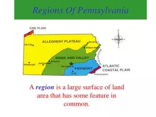
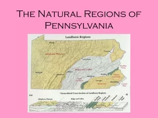
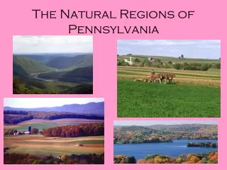
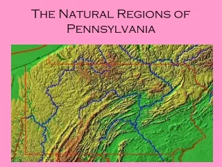
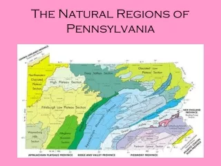
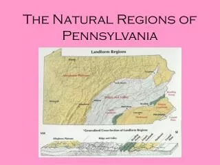
The Natural Regions of Pennsylvania. Atlantic Coastal Plain Region. The Atlantic Coastal Plain region is a strip of narrow, flat land in southeastern Pennsylvania. Atlantic Coastal Plain Region. The Delaware River flows through the Delaware River Valley on its way to the Atlantic Ocean.

E N D
Atlantic Coastal Plain Region • The Atlantic Coastal Plain region is a strip of narrow, flat land in southeastern Pennsylvania.
Atlantic Coastal Plain Region • The Delaware River flows through the Delaware River Valley on its way to the Atlantic Ocean.
Atlantic Coastal Plain Region • People settled along this river because it was a means of transportation, or a way to move people and goods.
Atlantic Coastal Plain Region • Philadelphia is located where the Schuylkill River and the Delaware River meet. Schuylkill River Delaware River Philadelphia
Atlantic Coastal Plain Region • The rivers made Philadelphia a center for trade, or markets where people could buy and sell goods.
Atlantic Coastal Plain Region • The Fall Line is the boundary between the higher land to the west and the lower coastal plain. Waterfalls are found there. The Fall Line prevents large ships from continuing up the Delaware River past Philadelphia.
Piedmont Region • The word piedmont means “foot of the mountain.”
Piedmont Region • The elevation of the Piedmont Region is higher than that of the Atlantic Coastal Plain. • The Appalachian Mountains lie to the west of the Piedmont Region
Piedmont Region • The Piedmont Region is a plateau with gently rolling hills and valleys. • A plateau is a large area of high, almost level land.
Piedmont Region • Many Amish live in and farm this region because the Piedmont’s soil is among the richest in the world. It makes it ideal for farming.
Piedmont Region The Amish mainly farm for a living.
Piedmont Region • Even without modern machinery, Amish farms are productive.
Piedmont Region • Amish people do not use modern conveniences like indoor plumbing and electricity.
Piedmont Region • Horses and carriages are used by the Amish instead of cars.
Piedmont Region • The Amish are a very religious people who live as their ancestors did.
Piedmont Region • A canal is a human-made waterway dug across the land. Canals usually connect two waterways so boats can travel through them.
South Mountain Region • Ridges and valleys are the two main land features in the South Mountain Region.
South Mountain Region • Few people live in this region because it is rugged and covered with forests.
Reading Prong Region • Low hills, steep ridges, and valleys are found in the Reading Prong Region.
Reading Prong Region • Erosion is the slow wearing away of soil and stone by wind and water.
Reading Prong Region • Erosion occurred slowly in this region because the ridges are made of hard types of rock.
Reading Prong Region • The Reading Prong Region is part of three mountain ranges: • Great Smokey Mountains • South Mountain • Blue Ridge Mountains They are all part of the huge Appalachian Mountain Range.
Ridge and Valley Region • This region is an area of many ridges and valleys.
Ridge and Valley Region • Coal is a fossil fuel that is found in the Ridge and Valley region that supplies power to many of the nation’s factories.
Ridge and Valley Region • Coal mining is the major industry in the Lackawanna Valley.
Ridge and Valley Region • Many crops are grown in the valleys of this region. Apples, grapes, cherries, berries, peaches, corn, hay, oats, and potatoes are just some!
Ridge and Valley Region • Large roads such as the Pennsylvania Turnpike, Interstates 80 & 81 help farmers transport their products.
Ridge and Valley Region • Harrisburg is the capital of Pennsylvania.
Ridge and Valley Region • Many caverns are found around Harrisburg. • Caverns are underground caves. • They are formed when water from rain mixes with soil and makes an acid which seeps through the ground and eats away at limestone creating a space underground.
Ridge and Valley Region • There are many activities people enjoy in the Ridge and Valley region. They include: hiking, fishing, picnicking, skiing, white-water rafting, boating, hunting, and camping.
Allegheny Plateau Region • The Allegheny Plateau has the largest area of any natural region in the state.
Allegheny Plateau Region • This region got its name from the Allegheny Mountains along its eastern edge.
Allegheny Plateau Region • The Allegheny Plateau is made up of mountains, hills, and valleys.
Allegheny Plateau Region • Glaciers are huge sheets of ice. Many years ago they cut long, deep valleys into the plateau.
Allegheny Plateau Region • Even though this region is covered with mountains, hills, and valleys, it is still considered a plateau. A long time ago, before glaciers cut the valleys into this region, it was a plateau. Today all the mountaintops are still about the same height.
Allegheny Plateau Region • The waterfalls at Ricketts Glen State Park were formed when glaciers carved out the land.
Allegheny Plateau Region • Mt. Davis, the highest point in Pennsylvania, is 3,213 feet above sea level.
Allegheny Plateau Region • Fallingwater, a famous house designed by Frank Lloyd Wright, is a famous landmark in the Allegheny Plateau.
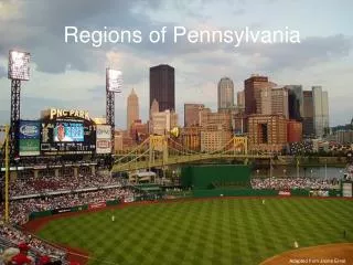
Allegheny Plateau Region • Pittsburgh is located where the Allegheny and Monongahela Rivers meet to form the Ohio River. These rivers provide transportation for people and goods.
Allegheny Plateau Region • Pittsburgh is a center of manufacturing and trade.
Allegheny Plateau Region • During the Civil War, Pittsburgh’s factories supplied the nation with steel and glass.
Allegheny Plateau Region • Pittsburg is home to many sports teams like the Steelers, Pirates, and Penguins.
Allegheny Plateau Region • Pittsburgh also has an opera, orchestra, and ballet.
Erie Lowland Region • The land in this region is low, flat land along Lake Erie.
Erie Lowland Region • Lake Erie is one of five Great Lakes. They are: • Lake Huron • Lake Ontario • Lake Michigan • Lake Erie • Lake Superior
Erie Lowland Region • The Great Lakes make up the largest group of freshwater lakes in the world.
Erie Lowland Region • The low, flat land of the Erie Lowland Region makes it ideal for building highways and railroads, making it a center of transportation.
Erie Lowland Region • The Erie Lowland Region has fertile soil which is good for growing many types of fruits and vegetables, including grapes.
Erie Lowland Region • Some crops are still taken to market through the port of Erie.