Download
1 / 1

E N D
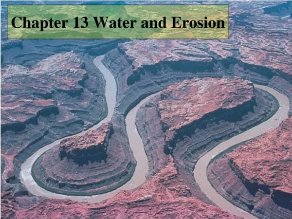
Water Erosion and the WEPP Model Protecting and improving the quality of water resources in agriculturally managed watersheds are major goals of the USDA National Water Quality Program. For many watersheds, sediment is the greatest pollutant. In watershed assessment, it is key to understand the sedimentation processes and their impact on water quality. Similarly, for successful implementation of erosion control Best Management Practices (BMPs), it is essential to determine the spatiotemporal distribution of sediment sources and the long-term effectiveness of sediment reduction by the BMPs prior to implementation. Using WEPP to Evaluate Integrated Environmental and Economic Impact of Flex-Cropping: Case Application 1 Water availability is the primary factor determining crop performance in the Pacific Northwest dryland region. A common practice to conserve water is the traditional summer fallow. Summer fallow, however, is inefficient with respect to soil water storage and is a major contributor to soil erosion. Improvements in soil-water use efficiency and reductions in soil erosion and sediment delivery could be realized by reducing the frequency of summer fallow in rotation and also by using conservation tillage and/or chemical means to fallow. Given the significant year-to-year fluctuation of precipitation, these options must be evaluated in terms of both environmental and economic effects. Such a goal can be most effectively achieved by using an erosion and crop-growth model such as WEPP. No-tillage Black fallow Recent, Major Changes to WEPP In the last few years, significant efforts have been devoted to continually improving and testing the WEPP model by researchers at WSU in close collaboration with USDA ARS and Forest Service (Wu et al., 2002, 2004a,b). The recent releases (v2004.7, 2006.2) features the following important improvements: Corrected modeling of hydraulic structures in small agricultural watersheds; Corrected and improved water balancing for complex application conditions; Added Penman-Monteith method, an international standard for ET estimation; Improved subsurface flow routines allowing adequate prediction of lateral flows along low-permeability layers and saturation-excess overland flow. Continuous Development, Application and Testing of WEPP The new release of WEPP was first tested using nearly 50 sets of data from the WEPP database. In addition, several major WEPP application and assessment efforts have been carried out at differing geographic locations, including: Small, forested watersheds in the Boise National Forest, SE Lowman, ID; Field experimental runoff and erosion plots at the USDA Palouse Conservation Field Station near Pullman, WA; Experimental plots and watersheds at the USDA Columbia Plateau Conservation Research Center in Pendleton, OR; Research experimental plots of University of Bologna near Bologna, Italy. WEPP—A Process-Based Hydrology and Erosion Model for Watershed Assessment and RestorationJoan Q. Wu1, William J. Elliot2, Donald K. McCool3, Markus Flury1, Dennis C. Flanagan4, Shuhui Dun11Department of Biological System Engineering, Washington State University, Pullman, WA 99164-61202USDA Forest Service Rocky Mountain Research Station, Moscow, ID 838433USDA-ARS Pacific West Area, Pullman, WA 99164 4USDA-ARS National Soil Erosion Research Laboratory, West Lafayette, IN 47907 Using WEPP as an Erosion Prediction Tool in Forest Resources Management: Case Application 2 Soil erosion in an undisturbed forest is typically very low (less than 1 t/ha/yr). Natural and human disturbances, such as wild- and prescribed fires and timber activities, however, can increase erosion significantly. Timber harvest operations influence soil erosion through the construction of roads, skid trails and log landings as well as the removal of vegetation. Prescribed fire is a management tool commonly used following timber harvest to reduce accumulated debris and the potential fire hazard, meanwhile facilitating planting and natural regeneration and the elimination of disease and insects. Soil erosion in a forested area is thus depends on multi-factors. WEPP is valuable for evaluating the numerous management alternatives. The USDA’s WEPP (Water Erosion Prediction Project) model is a process-based erosion prediction technology built on the fundamentals of hydrology, plant science, hydraulics, and erosion mechanics (Laflen, 1991; Flanagan et al., 1995). WEPP’s most notable advantages include its capabilities for estimating spatial and temporal distributions of soil detachment and deposition on an event or continuous basis. WEPP, in its GIS form (GeoWEPP), can be used to predict watershed responses to management practices, thereby serving as an efficient tool for BMP assessment. Current and Future Efforts Current efforts are focused on testing and incorporating an improved winter hydrology routine. Additionally, we are collecting and using field-measured forest and cropland data to test the newly incorporated Penman-Monteith ET model. Future efforts include (i) to examine and compare the WEPP crop growth component against other existing crop models and (ii) to examine the possibility to adapt the WEPP model for application to larger watersheds. Acknowledgements The study is supported through the funding of US Forest Service RMRS, US Geological Survey/State of Washington Water Research Center, and USDA CSREES NRI. Numerous scientists from the USDA-ARS-CPCRC and USDA-ARS-PWA have provided support and help. We especially thank Dave Robertson, Daryl Haasch, and John Morse for their tremendous help in the field work. Summary Significant efforts have been devoted to continually improving, testing, and applying the USDA’s WEPP model for use in watershed erosion prediction. The newest release, v2006.2 (accessible to the public at the USDA National Soil Erosion Research Laboratory http://topsoil.nserl.purdue.edu/nserlweb/index.html) includes a number of important improvements. An improved winter hydrology routine is expected to be included in the next major release. Several ongoing studies are focused on corroborating and applying the model using experimental research data collected at different geographic locations within and outside the US. For any detailed information, please contact Dr. Joan Wu at Department of Biological Systems Engineering Washington State University Pullman, WA 99164-6120 Phone: (509) 335-5996 Email: jwu@wsu.edu References Flanagan, D.C. et al. 1995. Overview of the WEPP erosion prediction model. In USDA Water Erosion Prediction Project: Hillslope Profile and Watershed Model Documentation, ed. D.C. Flanagan and M.A. Nearing, Ch. 1, NSERL Rep. 10, USDA-ARS NSERL, West Lafayette, IN. Laflen, J.M. et al. 1991. WEPP— A next generation of erosion prediction technology. J. Soil Water Cons. 46:34–38. Wu, J.Q. et al. 2004a. Modification and testing of the evapotranspiration (ET) routines in the WEPP Model, presented at the 2004 ASAE Meeting, Ottawa, Canada, Aug 1–4, 2004. Wu, J.Q. et al. 2004b. Subsurface water flow routines in the WEPP model: Modification and validation, presented at the 2004 ASAE Meeting, Ottawa, Canada, Aug 1–4, 2004. Wu, J.Q. et al. 2002. Adapting WEPP (Water Erosion Prediction Project) for forest watershed erosion modeling, Proc. 12th Int. Soil Conserv. Organization Conf., Beijing, China, May 26–31.