Download
1 / 7
70 likes | 105 Vues
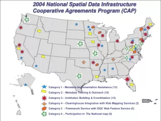
This program provides assistance in metadata implementation, training and outreach, institution building and coordination, web mapping service integration, framework data services establishment, and participation in The National Map.

E N D
2004 National Spatial Data Infrastructure Cooperative Agreements Program (CAP) Category 1 - Metadata Implementation Assistance (13) Category 2 – Metadata Training & Outreach (10) Category 3 – Institution Building & Coordination (13) Category 4 – Clearinghouse Integration with Web Mapping Services (2) Category 5 - Framework Service with OGC Web Feature Service (6) Category 6 – Participation in The National map (8)
Category 1 Metadata Creation and Implementation Metadata is an important first technical step toward data discovery and sharing as well as preserving an organization’s data investment. This category helps organizations acquire the skills and ability to document data to initiate metadata implementation.
Category 2 Metadata Training and Outreach This category assists organizations with metadata expertise and experience to assist other organizations. Project organizations will provide training and assist in the implementation of metadata, clearinghouse or web mapping services where needed.
Category 3 Institution Building and Coordination Organizations or consortia often need help to develop new, or strengthen existing, multi-organizational efforts that supports the development and maintenance of shared digital geographic resources. This category fosters the establishment of cross-organizational consortia that advance spatial data sharing within a geographic area.
Category 4 Implementing OpenGIS Web Mapping Service Standards based web mapping service allows users to graphically integrate data from multiple sources over the internet. This category provides assistance to existing registered clearinghouse nodes, serving metadata, to implement OpenGIS compliant web mapping service capabilities.
Category 5 Establishing Framework Data Services using the OpenGIS Web Feature Service Specification This category provides assistance for serving and using draft ANSI Standard Framework data over the Web using Geography Markup Language (GML) via the OpenGIS Web Feature Service specification. Projects are based on formal collaboration between a data provider and a software provider. Projects provide comment to the ANSI/INCITS Standards review, deploy software that supports Framework standards, and establish reference services for Framework data
Category 6 Participation in The National Map Assistance is provided to organizations and consortia that maintain, update and act as data providers - for participation in The National Map. Funds are provided to help new participants overcome impediments to participation and to help existing TNM participants improve their data services and provide them through The National Map in an on-going collaboration.