
Plate Boundaries and Earth Structure Exploration
E N D
Presentation Transcript
The three plate boundaries involved in tectonic Hazards: • CONSTRUCTIVE /Divergent boundaries -- where new crust is generated as the plates pull away from each other. • DESTRUCTIVE /Convergent boundaries -- where crust is destroyed as one plate dives under another. • CONSERVATIVE /Transform boundaries -- where crust is neither produced nor destroyed as the plates slide horizontally past each other. • There are also….Plate boundary zones -- broad belts in which boundaries are not well defined and the effects of plate interaction are unclear.
Artist's cross section illustrating the main types of plate boundaries (see text); East African Rift Zone is a good example of a continental rift zone. (Cross section by José F. Vigil from This Dynamic Planet -- a wall map produced jointly by the U.S. Geological Survey, the Smithsonian Institution, and the U.S. Naval Research Laboratory.)
True or False? The Earth is 4.6 billion years old. The earliest human remains are dated at less than 2 million years old. Systematic study of the Earth only began about 300 years ago. No major understanding of its structure or evolution was achieved until the past century. The country of Iceland did not exist 20 million years ago.
Supercontinents! Alfred Wegener put forward this theory in 1912… The Earth did not always look as it does today. It is believed that ~ 250 million years ago all the continents were joined together to form one “supercontinent” called Pangaea. Pangaea was a roughly “C” shaped landmass that spread across the equator.
In 1912 a German, Alfred Wegener, published his theory that a single continent existed about 300 million years ago. He named this super continent Pangaea and maintained that it had later split into the two continents of Laurasia in the north and Gondawanaland in the south. Today’s continents were formed from further splitting of these two masses.
Wegener’s model of continental drift What might happen 200 million years from now?
What evidence did Wegner use? 1. Continental fit Why don’t all the continents fit together snugly today?
2. Geological Evidence The Appalachian Mountains of eastern North America are thought to link to the Caledonides of Ireland, Britain, Greenland, and Scandinavia and the Anti-Atlas Range in Morocco.
3. Climatological evidence Coal deposits that would have been formed in tropical climate conditions are found in places that do not have a tropical climate. Therefore, they must have drifted. E.g. Antarctica, South Wales
Mesosaurus remains were found in southern Africa and eastern South America, two far away places. Mesosaurus was a freshwater animal, and could not have crossed the Atlantic Ocean, this indicates that the two continents used to be joined together. Marsupials are only found in Australia because it drifted away from the main supercontinent before the predators that wiped them out elsewhere had migrated there
So far: Wegener had convincing evidence for continental drift. However, sceptics were quick to point out that there was no explanation of the mechanismby which continents could move over a solid earth. It was not until the second half of the 20th century that major discoveries began to suggest how this might be possible.
New evidence in 1948 • A survey of the floor of the Atlantic Ocean revealed a continuous ridge running north to south. • It was 1000km wide. • Heights of 2.5km • Composed of volcanic rocks. • Similar found in Pacific Ocean.
1950’s Evidence = Paleomagnetism The striped pattern (which is mirrored exactly on either side of a mid-oceanic ridge) suggests that the ocean crust is slowly spreading away from this boundary and new rocks are being added equally on either side. This process is known as sea floor spreading.
Geomagnetic Polarity Reversals The Earth’s polarity reverses at regular intervals [approx every 400,000 years]. The result is a series of magnetic ‘stripes’ with rocks aligned alternately towards the north and south poles. This is known as ‘Polar Wandering’
Earth’s geomagnetic field is recorded as new crust cools. 3-3 New crust. Parallel bands of crust with the same magnetism form along the ridge. Driving Mechanisms for Plate Motions
Pull slabs of oceanic crust back down into the mantle at suduction zones. Pull crust apart at spreading ridges. The Driving Mechanism for Plate Movement
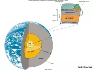
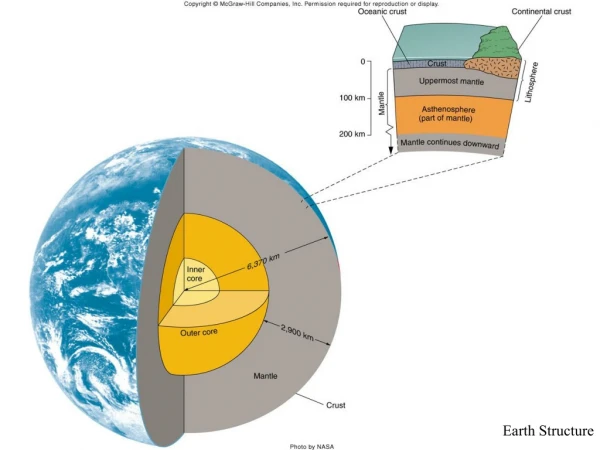
Movement of plates is caused by thermal convection of the “plastic” rocks of the asthenosphere which drag along the overlying lithospheric plates. 3-3 Driving Mechanisms for Plate Motions
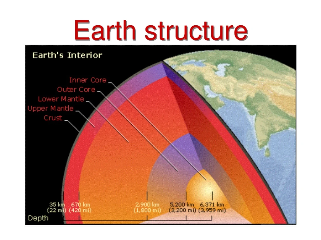
Earth’s surface is composed of a series of lithospheric plates. Plate edges extend through the lithosphere and are defined by seismicity. • Plate edges are trenches, oceanic ridges and transform faults. • Seismicity and volcanism are concentrated along plate boundaries.
CONSTRUCTIVE/Divergent Boundaries • Boundary between two plates that are moving apart or rifting • RIFTING causesSEAFLOOR SPREADING
Convection Currents • Hot magma in the Earth moves toward the surface, cools, then sinks again. • Creates convectioncurrents beneath the plates that cause the plates to move.
Features of Constructive/Divergent Boundaries • Mid-ocean ridges • rift valleys • fissure volcanoes
Lava fountains (10 m high) spouting from eruptive fissures during the October 1980 eruption of Krafla Volcano. (Photograph by Gudmundur E. Sigvaldason, Nordic Volcanological Institute, Reykjavik, Iceland.)
Aerial view of the area around Thingvellir, Iceland, showing a fissure zone (in shadow) that is the on-land exposure of the Mid-Atlantic Ridge. Right of the fissure, the North American Plate is pulling westward away from the Eurasian Plate (left of the fissure). Large building (near top) marks the site of Lögberg, Iceland's first parliament, founded in the year A.D. 930. (Photograph by Oddur Sigurdsson, National Energy Authority, Iceland.)
In East Africa, spreading processes have already torn Saudi Arabia away from the rest of the African continent, forming the Red Sea. The actively splitting African Plate and the Arabian Plate meet in what geologists call a triple junction, where the Red Sea meets the Gulf of Aden. A new spreading center may be developing under Africa along the East African Rift Zone.
DESTRUCTIVE/Convergent Boundaries • Boundaries between two plates that are colliding • There are 3 types…
Type 1 • Ocean plate colliding with a less dense continental plate • Subduction Zone: where the less dense plate slides under the more dense plate • VOLCANOES occur at subduction zones
Ring of Fire Challenger Deep got its name from the British survey ship Challenger II, whichpinpointed the deep water off the Marianas Islands in 1951.
Type 2 • Ocean plate colliding with another ocean plate • The less dense plate slides under the more dense plate creating a subduction zonecalled a TRENCH
Type 3 • A continental plate colliding with another continental plate • Have Collision Zones: • a place where folded and thrust faulted mountains form.
CONSERVATIVE/ Transform Fault Boundaries • Boundary between two plates that are sliding past each other • EARTHQUAKES along faults
3-4 Conservative The San Andreas fault in southern California is a transform fault that connects the sea-floor spreading ridge of the Gulf of California with the spreading ridge off Oregon and Washington. • If these plate motions continue, Baja will splinter off California.
Conservative Because the San Andreas fault has an irregular trace, strike-slip motion can cause local compression or tension. 3-4