The Geologic Column
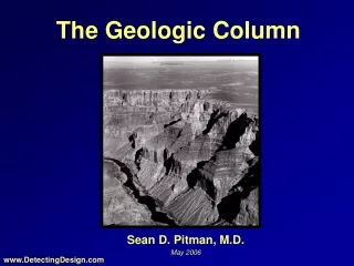
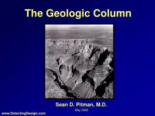
The Geologic Column. Sean D. Pitman, M.D. May 2006. www.DetectingDesign.com. Features of the Geologic Column. Made of layers of sedimentary rock Layers generally very flat/even relative to each other Found generally all over the globe Some areas have missing layers

The Geologic Column
E N D
Presentation Transcript
The Geologic Column Sean D. Pitman, M.D. May 2006 www.DetectingDesign.com
Features of the Geologic Column • Made of layers of sedimentary rock • Layers generally very flat/even relative to each other • Found generally all over the globe • Some areas have missing layers • Some areas have most if not all the layers • Found on mountains such as the Swiss Alps, Mt. Everest, American Rockies, Himalayas, Appalachians, etc . . . • Popularly thought to record millions and even billions of years of Earth’s history
Foot of the Book Cliffs northwest of Grand Junction, CO
Layers are flat/even relative to each other • Layers often extend over hundreds of thousands of square miles • Where is the expected unevenness usually seen with weathering?
The Speed of Erosion • Rockies currently uplifted at 100-1000 cm/Kyr • No change in elevation • Erosion rate is matching uplift rate • Current uplift thought to have started 70 million years ago (Laramide Orogeny) • An erosion rate of 100 cm/Kyr equals 1,000 meters of erosion per million years or an incredible 70,000 meters in 70 million years • Total thickness of layers in this region is ~3,500 meters – including the Tertiary layers
Ruxton and McDougall (1967) report erosion rates of 8 cm/Kyr near sea level and 52 cm/Kyr at an altitude of 975 m in the Hydrographers Range in Papua • 92 cm/Kyr for Guatemala-Mexico Border Mountains • Himalayas = 200 cm/Kyr • 800 cm/Kyr for Mt. Rainier region • 1900 cm/Kyr New Guinea volcano • Chugach and St. Elias mountain ranges in southeast Alaska, are currently eroding at "50 to 100 times" the current Rocky Mountain rate - i.e., at about 5 to 10 cm/year or 50,000 to 100,000 meters or erosion per million years • Yet, many of these mountain ranges still have very "old" sedimentary layers on their surfaces? Go figure . . . Ariel Roth: http://www.grisda.org/origins/13064.htm
Mt. Everest • Thought to be about 50 million years old • Himalayan erosion rate ~200cm/kyr • Just 100 cm/Kyr of erosion equals ~50,000 vertical meters of erosion in 50 My • Still covered by Ordovician limestone - only about halfway down the column! • Perhaps the layers used to be much thicker? • Only some 6000 m of sediment once covered Everest • Harutaka Sakai suggest have of Everest slid off 20 Ma • Ordovician exposed for 20 Ma and its still there? Really?
The Colorado Plateau • Colorado River sediment equals 500,000 tons per day • before Glenn Canyon dam • Sandstone = 140 pounds per cubic foot • 7.1 million cubic feet of erosion per day from an area of ~200,000 square miles (~5.57 trillion sqft) • 2.6 billion cubic feet of erosion per year • Colorado Plateau uplifted ~15 million years ago? • 38,000 trillion cubic feet of erosion in 15 million years • 7,000 vertical feet (2,100 m) eroded in 15 million years • Tertiary sediments survived atop the Grand Staircase?
~2000 m Why did ~2000 vertical meters erode in one region, but not in the other? Was there really an additional 2,100 meters of tertiary sediment above Brian Head? Shouldn’t the higher reliefs erode more quickly?
Brian Head Oligocene 32 Ma Kaibab Limestone Paleozoic 250 Ma
Today’s continents average 0.875 km above sea level • Land surface area: 148,647,000 sq km • Cubic km above sea level: 130,066,125 km3 • An average of several references suggest that about 13.6 km3 of solid material are carried by all the rivers of the Earth into the oceans every year • 31,000 million metric tons/year • Time needed to erode away all land currently above sea level: ~9.5 million years http://worldatlas.com/geoquiz/thelist.htm
What About Human Impact? “Humans have simultaneously increased the sediment transport by global rivers through soil erosion (by 0.6 - 2.3 billion metric tons per year), yet reduced the flux of sediment reaching the world’s coasts (by 0.3 - 1.4 billion metric tons per year) because of retention within reservoirs.” James P. M. Syvitski, Charles J. Vo¨ro¨smarty, Albert J. Kettner, Pamela Green Impact of Humans on the Flux of Terrestrial Sediment to the Global Coastal Ocean, Science, VOL 308, 15 APRIL 2005
C. R. Twidale recognized this problem as far back as a 1976 in the American Journal of Science: “Even if it is accepted that estimates of the contemporary rate of degradation of land surfaces are several orders too high (Dole and Stabler, 1909; Judson and Ritter, 1964; see also Gilluly, 1955; Menard, 1961) to provide an accurate yardstick of erosion in the geological past there has surely been ample time for the very ancient features preserved in the present landscape to have been eradicated several times over. . . ”
“ . . . Yet the silcreted land surface of central Australia has survived perhaps 20 m.y. of weathering and erosion under varied climatic conditions, as has the laterite surface of the northern areas of the continent. The laterite surface of the Gulfs region of South Australia is even more remarkable, for it has persisted through some 200 m.y. of epigene [surface] attack. The forms preserved on the granite residuals of Eyre Peninsula have likewise withstood long periods of exposure and yet remain recognizably the landforms that developed under weathering attack many millions of years ago. . . The survival of these paleoforms [as Kangaroo Island] is in some degree an embarrassment to all of the commonly accepted models of landscape development.”
Dott and Batten (1971) noted: "North America is being denuded at a rate that could level it in a mere 10 million years, or, to put it another way, at the same rate, ten North Americas could have been eroded since middle Cretaceous time 100 m.y. ago."
B.W. Sparks (1986) in Geomorphology: "Some of these rates [of erosion] are obviously staggering; the Yellow River could peneplain [flatten out] an area with the average height that of Everest in 10 million years. The student has two courses open to him: to accept long extrapolations of short-term denudation [erosion] figures and doubt the reality of the erosion surfaces, or to accept the erosion surfaces and be skeptical about the validity of long extrapolations of present erosion rates."
The “Smooth” Grand Canyon Dome ~2000 m
Beartooth Butte • 300-400 million yeas old • Same layers: Paleozoic
http://www.geology.wisc.edu/~maher/air/air07.htm Sheep Mountain, WY
Bighorn River Canyon Between Pryor and Bighorn Mountains, MT
W S N E
The Real Grand Canyon Straight shot with few twists or U-shaped turns
Thick pile of basalt lava flows (~2,000 m thick) • Cover 500,000 km2 with a volume of >1,000,000 km3 • Thought to have formed about 65 mya over the course of 30,000 years and played a role in the extinction of the dinosaurs • Individual flows understood to form very quickly (a few days) because they cover over 100 miles • Time between lava flows: 2 to 3 hundred years • Not enough time for significant erosion between flows