Validating water resources described in WaterML 2.0
20 likes | 181 Vues
Printing an A0 Poster Option 1 (recommended) - print your AO poster directly from PowerPoint. Option 2 – Create a PDF using one of the two methods below: Method 1 Click File – Print to open the Print dialogue box Change the printer to PDF Creator

Validating water resources described in WaterML 2.0
E N D
Presentation Transcript
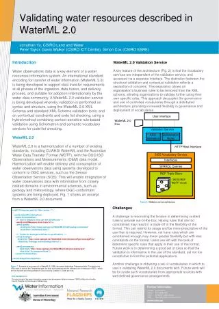
Printing an A0 Poster • Option 1 (recommended) - print your AO poster directly from PowerPoint. • Option 2 – Create a PDF using one of the two methods below: • Method 1 • Click File – Print to open the Print dialogue box • Change the printer to PDF Creator • Click Properties to change the PDF settings. Ensure that the Portrait box is checked. • Select the Advanced tab • Change the paper size to A0 • Ensure print quality is set at 600 dpi (print quality) • Click OK • Preview your poster and Print • Method 2 • 1. Click File – Print to open the Print dialogue box • 2. Select the Printer Name – Adobe PDF • 3. Click Properties to change the PDF settings. In the Adobe PDF Document Properties select the Adobe PDF Settings tab • a. Change Default Settings to ‘Press Quality’ • b. Change Adobe PDF page size to ‘A2’ (PowerPoint will not PDF to A0 size). • c. Select the Layout tab and ensure the Orientation is set to ‘Portrait’ • d. Close the Properties window • Preview your poster and Print User interface WaterML 2.0Doc Validation Service XSD Validation SchematronRules HTTP Rest Interface SISS Vocabulary Service Interfaces SPARQL Queries RDF Triple Store SKOS/RDF WDTF Vocab Poster Title: Font size and line spacing can be altered in this section to suit the length of your title. Your title must be vertically aligned to the bottom. Validating water resources described in WaterML 2.0 Author names and affiliation: This information must always be placed in this blue strip.If more space is required, affiliations can be listed under the blue bar. Jonathan Yu, CSIRO Land and WaterPeter Taylor, Gavin Walker (CSIRO ICT Centre), Simon Cox (CSIRO ESRE) Introduction Water observations data is a key element of a water resources information system. An international standard encoding for transfer of water information (WaterML 2.0) is being developed to support data transfer requirements at all phases of the ingestion, data fusion, and delivery process, and suitable for adoption internationally by the water data community. A WaterML 2.0 validation service is being developed whereby validation is performed on syntax and structure, using the WaterML 2.0 XML Schema and standard XML Schema validation tools; and on contextual constraints and code list checking, using a hybrid method combining context-sensitive rule-based validation using Schematron and semantic vocabulary services for code-list checking. WaterML 2.0 WaterML 2.0 is a harmonization of a number of existing standards, including CUAHSI WaterML and the Australian Water Data Transfer Format (WDTF), with the OGC/ISO Observations and Measurements (O&M) data model. Harmonization will enable delivery and consumption of water observations data using systems developed to conform to OGC services, such as the Sensor Observation Service (SOS). This will enable integration of water observations data with information from closely related domains in environmental sciences, such as geology and meteorology, where OGC-conformant systems are being deployed. Fig. 1 shows an excerpt from a WaterML 2.0 document. WaterML 2.0 Validation Service A key feature of the architecture (Fig. 2) is that the vocabulary services are independent of the validation service, and accessed via a separate interface. The distinction between the structural validation and contextual validation reflects a separation of concerns. This separation allows an organisation’s business rules to be removed from the XML schema, allowing organisations to validate further using their own specific rules. This approach decouples the governance and use of controlled vocabularies through a distributed architecture, providing increased flexibility in governance and deployment of vocabularies. Poster content area: Images may bleed off to the right or left or butt up against the grey bar at the top. Keep within the content area indicated by the guides. Figure 2: Validation service architecture. Challenges A challenge is reconciling the tension in determining content rules to provide out-of-the-box. Having rules that are too constrained may result in a trade-off in the flexibility of the format. This can restrict its usage and be more prescriptive of the use than is required. However, not have rules which are constrained enough may mean greater flexibility but with less constraints on the format. Users are left with the task of determine specific rules that apply in their use of the format. Future work is in determining a good set of rules so that the validation is informative in the use of the standard, yet not too constrictive to limit the potential applications. Another challenge is obtaining a set of vocabularies in which to use in validating WaterML 2.0 documents with. Future work will be to curate such vocabularies from appropriate sources with well-defined governance arrangements. <wml2:Timeseries gml:id="time_series_1"> … <wml2:defaultTimeValuePair> <wml2:TimeValuePair> <!-- Unit of measure must use the UCUM code --> <wml2:unitOfMeasure xlink:href="m"/> <wml2:quality xlink:href="http://www.opengis.net/WaterML2.0/def/quality/unchecked" xlink:title="unchecked data"/> <!-- Codes for data types defined in specification. --> <wml2:dataType xlink:href="http://www.opengis.net/WaterML2.0/def/timeseriesType/AveragePrec" xlink:title="Average in preceeding interval"/> <wml2:processing xlink:href="http://www.opengis.net/WaterML2.0/def/processing/raw" xlink:title="As measured data"/> </wml2:TimeValuePair> </wml2:defaultTimeValuePair> Figure 1: Example of an excerpt of a WaterML 2.0 XML document describing Timeseries data. Of note are the URIs used to denote the Timeseries type, the kind of processing and the relevant unit of measure in RED – which will be checked according validation rules involving codelist or vocab services References & acknowledgements: Can appear on top of the grey texture bar if you don’t have enough room on your poster. Acknowledgements This work is part of the water information research and development alliance between CSIRO’s Water for a Healthy Country Flagship and the Bureau of Meteorology contact: Jonathan Yu phone: (03) 9252 6440 email: Jonathan.Yu@csiro.auweb: http://www.csiro.au/org/clw.html Further information: Insert your contact details, including a divisional/ unit specific url.