Download
1 / 15
150 likes | 316 Vues
Louisiana State University. “The Case for Continuing and Strengthening NDGPS in Louisiana”. Roy K. Dokka, Ph.D. Center for GeoInformatics and Louisiana Spatial Reference Center Louisiana State University, Baton Rouge, LA 70803. Today’s Program.

E N D
Louisiana State University “The Case for Continuing and Strengthening NDGPS in Louisiana” Roy K. Dokka, Ph.D. Center for GeoInformatics and Louisiana Spatial Reference Center Louisiana State University, Baton Rouge, LA 70803
Today’s Program • Why do we need the NDGPS system in Louisiana? • Why do we need it right now?
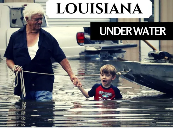
Louisiana: A vulnerable landscape with a constantly changing geodetic control system NOAA told the U.S. Congress in 2001 that the system used to measure elevations in LA was, “inaccurate and obsolete and unable to support public safety.” Bad vertical control affects levees, planning, evacuation roads, FEMA flood maps, and LiDAR.
LSU’s Role in Fixing the Problem • Creation of GULFNet GPS Reference Network across South Louisiana 42 CORS. Users can access the National Spatial Reference System anywhere in Louisiana with confidence. Think of CORS as “smart benchmarks”. GULFNet is updated daily and will remain accurate into the future without costly re-observations. Heights recognized as legal under Louisiana State law. www.ngs.noaa/CORS • Creation of a State-wide Real-time Network GULFNet real-time kinematic GPS RTN network allows users to obtain accurate and precise 3-D positions anywhere-anytime in Louisiana. Precision: 1 cm Horiz., 2 cm Vert. Users can obtain 2004.65 elevations by site calibration. • Training Provide know-how to enable users to exploit the new resources. “Positioning Louisiana for the future”
What is the overall strategyregarding 3-D positioning in LA? • The ability to obtain accurate 3-D positions has always been a shared responsibility between NGS, local government, surveyors, and others. • NGS is committed to providing users in LA with access to the NSRS. This means maintaining a basic backbone of about a hundred benchmarks in south Louisiana, supporting CORS, development of technical standards. • C4G will provide state-wide GNSS technology to facilitate accurate and precise “anywhere-any time” 3-D positioning. • Local people will have to decide how they wish to access the NSRS. NGS and C4G are dedicated to helping individual parishes craft viable local solutions to meet local needs and $$ issues.
Based on LSU GULFNet CORS, the most reliable component of the National Spatial Reference System in Louisiana. • Fully implemented in Louisiana. Includes stations in Texas and Mississippi. Error is 1 cm Horiz. 2cm Vert., EVERYWHERE! GULFNetRTN
RTN Real-Time Network Based on VRS technology “Positioning anywhere, any time” Relative vertical: + 2 cm (3 min.) Kinematic mode: + 0.3 ft (1 sec.) Cellular device to connect user to Internet and LSU GULFNet RTN Native output in “CORS 2002” but can easily be put in 2004.65 context through calibration.
The Louisiana Legislature requested LSU measure the height of the South LA HPS in 2006-2007. N = 50,000 points Note: Does not reflect post 2007 changes Due to construction by USACE
NDGPS is still needed because GULFNet is . . . . . • not likely to be operational following a • major hurricane because of damage to • cellular and internet communications. • limited by cellular coverage, whereas • the NDGPS signals are everywhere. • land-centric, whereas NDGPS is also • offshore.
NDGPS is still needed because GULFNet is . . . . . • not likely to be operational following a • major hurricane because of damage to • cellular and internet communications. • limited by cellular coverage, whereas • the NDGPS signals are everywhere. • land-centric, whereas NDGPS is also • offshore.
What else could be done? • Adding more corrections to the broadcast signal. • LSU can create an array of virtual CGPS stations to better blanket the state.