Download
1 / 13
130 likes | 291 Vues
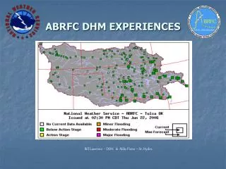
Using GFE as a DHM Grid Editor. ABRFC testing. Prototype procedure developed for “GFE at the RFCs” OSIP project. Uses ABRFC-developed tools to read / write XMRG-formatted data into / from GFE. Uses existing GFE smart tools to modify the imported data. Details….

E N D
ABRFC testing • Prototype procedure developed for “GFE at the RFCs” OSIP project. • Uses ABRFC-developed tools to read / write XMRG-formatted data into / from GFE. • Uses existing GFE smart tools to modify the imported data
Details… • Proof-of-concept only. Procedure tested on precipitation data but can work for any XMRG-formatted data (e.g. soil moisture). Needs modifications for more general use. • NWSRFS-like “mods” are performed on the data with mathematical GFE smart tools. • Examples: • Use the “Adjust” tool for “RRIMULT.” • Use “Assign Value” tool for “RRICHNG.”
Details… • Testing with default GFE projection showed unacceptable data distortions were introduced when translating from / to HRAP while reading / writing XMRGs. • ABRFC now runs GFE server on HRAP projection – suitable for current operational use.
Questions ? ______________________Demonstration ?