Download
1 / 31
310 likes | 384 Vues
Conception of a global SAR mission for land imaging on the tropics. Gilberto Câmara Director General National Institute for Space Research (INPE) Brazil. Motivation: Brazilian National Plan for Climate Change. How can Brazil achieve its deforestation targets?.

E N D
Conception of a global SAR mission for land imaging on the tropics Gilberto Câmara Director General NationalInstitute for SpaceResearch (INPE) Brazil
Motivation: Brazilian National Plan for Climate Change How can Brazil achieve its deforestation targets?
INPE has international credibility “Today, Brazil’s monitoring system is the envy of the world. INPE has its own remote sensing satellite, a joint effort with China, that allows it to publish yearly totals of deforested land that scientists regard as reliable.” TerraAmazon
Other countries want to help Until 2015, Norway will give up to US$ 1 billion to reduce deforestation in the Amazon. Norway’s contribution will depend on how successful Brazil will be in reducing deforestation. Brazil has the largest rain forest and one of the world’s most advanced systems for surveillance of deforestation.
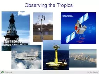
Challenge: Cloud cover in the tropics • Most tropical areas have > 50% cloud cover yearly • (source: International Satellite Cloud Climatology Project)
Challenge: Cloud cover in Amazonia • São Félix do Xingu, Brazil, cloudcoveredfromOctober to May
2000 2001 2002 2003 2004 2005 2006 Less than 10 ha 5% 4% 6% 8% 9% 9% 10% 10 a 25 ha 11% 6% 12% 14% 16% 20% 25% 25 a 50 ha 11% 5% 11% 11% 13% 16% 19% 50 a 100 ha 12% 6% 13% 12% 13% 14% 16% 100 a 150 ha 8% 3% 8% 7% 7% 7% 7% 150 a 300 ha 12% 6% 14% 12% 11% 11% 10% More than 300 ha 38% 68% 31% 32% 27% 22% 13% Challenges: clearing size is falling Deforestation classes per area Aumento Estável Redução Tendência de Redução Aproxim. Estável Tendência de Aumento
Challenge: deforestation during the rainy season Landsat/TM August 2007 MODIS November 2007 Alerta DETER nov-2007
CheckingDETER´s data (February 2008) Clearingland for pastureduringtherainyseason
Challenge: need for medium-resolution data during the rainy season New deforestation shown by DETER Landsat/TM 226/68 17/Ago/2007 DETER out-2007
Checking DETER´s data (February 2008) Exploração – estágio inicial Intensivetimberextractionduringtherainyseason
SAR user requirements in Brazil Source: Brazilian SAR users workshop, 2002 + recentadditions (Forestry) Workshop organizer (2002): W. ParadellaRecentadditions: D. Valeriano
Motivation for L-band SAR: Amazonia PETROBRAS Solimões Terminal, Coari [LHH(R) + LVV (G)+LHV(B)] Images from R99B airborne SAR (SIVAM) in 2005 Campaign chief scientist (INPE): Waldir Paradella Researcher: F. P. Miranda (PETROBRAS)
Motivation for L-band SAR: Amazonia Tapajós National Forest [ 10 m res, LHH(R) + LVV (G) + LHV (B)] Images from R99B airborne SAR (SIVAM) in 2005 Campaign chief scientist (INPE): Waldir Paradella INPE researchers: C. Freitas, J. R. Santos, L.V. Dutra, C. Mura
Motivation for L-band SAR: Coastal regions Bragança, Pará [10 m res, LHH(R) LVV(G) LHV(B)] Images from R99B airborne SAR (SIVAM) in 2005 Campaign chief scientist (INPE): Waldir Paradella Researchers: P. W. Souza (UFPA), M. T. Prost (MPEG)
Motivation for L-band SAR: Agriculture L.E. Magalhães, Bahia [ 10 m resul, LHH(R)+LVV(G)+LHV(B)] Images from R99B airborne SAR (SIVAM) in 2005 Campaign chief scientist (INPE): Waldir Paradella INPE researchers: B. Rudorff, A.R. Formaggio
Industrial motivation: Brazilian OrbiSAR-1 SYSTEM X-band SAR-Image 3x3m Campinas, Brazil)
Industrial motivation: Brazilian OrbiSAR-1 SYSTEM P-band SAR-Image 3x3m, Sorocaba, Brazil (10/2002)
Industrial motivation: Brazilian OrbiSAR-1 SYSTEM X-band SAR-Image 3x3m, Campinas, Brazil
LANDSAR (SAR for world´s tropics) Sun-Synchronous Dawn-Dusk Orbit; Full Power on descending and ascending; Double-sided access by roll maneuver; 5-day full world coverage at 30m; 25-day full world coverage at 10m; 1-day spot at 5m;
LANDSAR (SAR for world´s tropics) Positioning Control: 100m Positioning Determination: 30cm near real time. Attitude : Control - 0.1º in roll, pitch and yaw Determination - 0.05º in roll, pitch and yaw Timing Accuracy: 50us.
LANDSAR Modes (initial proposal) ScanSAR TOPSAR • ScanSAR/TOPSAR: • Number of range looks of detected products: 4 • Total ground range swath at the equator: 560km • Resolution: 30 m x 30 m • Global coverage time at the equator: 5 days • Polarization: HH+HV
LANDSAR Modes (initial proposal) Stripmap Number of range looks of detected products: 8 Total ground range swath at the equator: 115km Resolution: 14 m x 14 m Coverage time at the equator: 25 days Polarization: HH+HV Spotlight • Number of range looks of detected products: 2 • Total ground range swath at the equator: 50km • Resolution: 5 m x 5 m • Time for Surveying: 1 day • Polarization: HH+HV
LANDSAR Polarization + InSAR Interferometric SAR Polarization HH + HV
LANDSAR Operational Capabilities:Amazonia in 5 days with 30 m resolution
LANDSAR Operational Capabilities:Amazonia in 25 days with 10 m resolution