Download
1 / 55
550 likes | 784 Vues
Bridging the Gaps Situational Awareness and Assessment. Public Health and Radiation Emergency Preparedness Conference March 22, 2011 CDC, Atlanta, Georgia. Panel. Harvey Clark, PhD, Principal Scientist, DOE Remote Sensing Laboratory

E N D
Bridging the GapsSituational Awareness and Assessment Public Health and Radiation Emergency Preparedness Conference March 22, 2011 CDC, Atlanta, Georgia
Panel • Harvey Clark, PhD, Principal Scientist, DOE Remote Sensing Laboratory • Bill Irwin, ScD, CHP, Radiological Health Chief, Vermont Department of Health • James Kish, BS, Technological Hazards Division Director, FEMA • Patricia Milligan, BS, Senior Technical Advisor, Preparedness and Response, NRC
The Setting for This Panel • We will discuss situational awareness and assessment tools, and present questions about their value. • We will describe their use by state and federal agencies in radiological and nuclear emergencies which include: • Nuclear power plant accidents; • Hostile actions – radiological dispersion devices, radiological exposure devices, mass or individual poisonings; • Transportation incidents; • Nuclear weapons or improvised nuclear device (IND) detonations; and • Criticality accidents at nuclear facilities. • Nevertheless, what is presented here can be applied in most instances if you substitute the word chemical agent or biological agent for radiological agent.
Situational Awareness and Assessment is Critical • Who in the public needs to know what when? • Could it be that an informed populace generally responds more constructively than if they only operate on informally obtained information? • How much is too much to share? • How much of the status of operations should the emergency responders be provided? • What is sufficient so they can see the whole of it and understand their work relative to objectives? • Can too much information lead them to inappropriate action? • What if the information is inaccurate, too complicated or poorly presented?
How the Public Builds Situational Awareness • They will likely hear or see things about the situation in: • Commercial media • Internet • Personal conversation • They might get some information from the government, e.g., public affairs, the communications office, the Public Information Officer (PIO) or other source. • Can a lack of timely and accurate information from the PIO or other party in possession of the facts leave the public vulnerable to acting on inadequate or wrong information?
And What about Emergency Responders? • They have the same sources usually, the PIO, commercial media, internet and personal conversation, but they also ought to have: • An Incident Action Plan (IAP); • Data products like maps, charts, graphs, field data, computer models and photographs; and • The guidance of technical advisors. • One of the challenges is getting information to field offices that may not have sufficient resources including internet access and plotters for printing large documents.
What Information Depicts the Situation for the Public and Emergency Responders? • Likely the same for each party, though that for the public may be limited in extent and detail: • What happened; • What authorities are doing about it; • What people can do to help; • What people can do to protect themselves; • What consequences are possible; • What consequences are likely knowing what we do at the time; • Where to go for help; and • Where to get additional information. • Photos and videos feed the mind these days; we need to use them.
Maps are Perhaps the Most Useful Means to Display Information • Where the incident occurred • Restricted areas with traffic control points • Emergency facilities available for those affected including • Community reception centers, • Congregate care facilities, • Medical countermeasures points of distribution, and • Available medical facilities.
Maps are Perhaps the Most Useful Means to Display Information • Where inputs to the food chain are restricted, and • Critical infrastructure that is not currently accessible; • Electric, water, communications and other utilities • Government offices, including police, fire and ambulance • Businesses, especially major employers • Schools • Health care facilities • Farms • Food retailers and wholesalers • Road, rail, boat and air transportation – thos open; those closed
Dose Assessment Tools • Dose and contamination projection models. • RESRAD: A library of models for radiation and contamination effects for most incidents • RASCAL: for nuclear power plant and spent fuel accidents • A raft of other models from various government sites and private firms, e.g. ALOHA, CAMEO, MARPLOT • Field team radiation and contamination surveillance data. • Aerial monitoring results.
Dose Assessment Tools • Environmental instruments like EPA’s RadNet, DOEs Comprehensive Test Ban Treaty monitors, and those of states and local government. • Standardized presentations – how many times standards, how many times background, actual units • The US is severely hampered by not adopting SI units – confusion is bad enough without having sieverts and rem, gray and rads, becquerrel and curies. • Emergency responder and public dose and contamination records. • Emergency responder and public contaminated injury records. • Medical records for radiation overexposures. • There are still privacy concerns to be met.
But, Its Not Just About Dose • Weather • It may have been a cause • It may make things better or worse • It affects dispersal and fallout of the agent • It affects the timeliness and nature of many elements of the response • It affects the terrain • Used and available beds for medical and special needs populations. • Personal protective equipment inventories. • Medical countermeasures inventories. • Emergency responder staffing rosters.
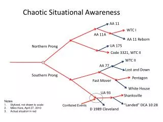
One State’s Experience Vermont and Empire 09
Public information was useful for situation awareness for responders
. The Department of Energy can get these kinds of maps to sophisticated fixed facilities. For field units to get them, they must have laptops and air cards. To use them for briefings or other display, they need printers or large monitors
A National Atmospheric Release Advisory Center (NARAC) data product. Great for decision makers. What about other emergency responders? What about the public? How do you keep from confusing any of these audiences with this unique language and unsettling and mysterious source of exposure?
The state has tested field teams which collect environmental samples for laboratory analysis for many years. The teams had no incident command structure, however, after they were deployed to forward camps. We asked Region 1 EPA to bring in an Emergency Response Team. They provided us additional sampling teams and an ICS structure. Their tent wasn’t bad either.
As teams deploy, we must maintain accountability as well as progress toward meeting incident objectives
In addition to having a wealth of communications platforms which made internet communications possible, the EPA mobile command post also came with a plotter that could be used to print large documents needed to provide briefings to large groups and to show activities taking place across the four state region affected by the RDDs in Albany, NY.
The EPA deployed its RadNet units for detailed beta and gamma radiation, airborne radioactivity measurements and basic weather which are sent by wireless signals to EPA headquarters in Washington, DC. This one was at the sampling base camp. Others were deployed to forward areas of fallout deposition.
States, even the biggest, are not likely to have sufficient people to do it all. We had to sample more than 6,000 square miles that were modeled as contaminated. How can you integrate federal and other state teams without situational awareness?
Some may require teleconference capabilities to link widely Briefings are critical. dispersed assets. One briefing here used a blackberry on speaker phone for an address to all emergency responders from a high ranking government official
Connecticut lent us their mobile radiochemistry laboratory under the New England Compact. We were able to process high priority samples right at the sampling base camp. Who should hear the sampling results?
Geographical information systems (GIS) are invaluable for displaying the situation over layers of critical infrastructure like health care facilities, fire stations, ambulance facilities, utilities, farms, reservoirs and roads.
The Resources of the Department of Energy and the Federal Radiological Monitoring and Assessment Center (FRMAC)
8 8 5 1 6 7 2 3 7 2 4 2 Radiological Assistance Program • Advise on radiological issues • First responder - arrives in 4-6 hours • Assist with radioactive material recovery • Assist with the characterization of radiological incident
Advisory Team • Provides coordinated advice and recommendations on environment, food and health matters to the Federal, state, local and tribal governments. • Representatives from: • EPA - FDA • CDC - USDA • Other Federal agencies as needed
AMS On-Call Response • Beech King Air B-200 • Avg. post-flight data processing time: 1 hour • Data Products: Breadcrumb overlay plot • Real-time data telemetry Mission: Get data from large area quickly, Fly high and fast Activation: 5 to 10 hours on site 29
AMS Radiological Mapping Helicopter Response Bell-412 • Data product: Contoured ground exposure map • Data processing time: 3-4 hours • Intermediate phase product • Mission: Get more detailed data. Fly low and slow • Activation: 8 to 20 hours to site
CM Response Team I Mission: Initial field element of FRMAC Activation: 4 hours following notification Operations – 24 hours (for limited time) Capabilities • Assessment • Geographical Information Systems • Health & Safety • Monitoring & Sampling • Five field teams • Logistics
CM Response Team II • Additional responders • 24-hour/day operation for several weeks • Augmented monitoring, sampling and assessment • Additional equipment • 20 field teams • Laboratory Analysis • Sample receipt • Prepare samples for transport to labs • Training for additional responders Mission: Complete CMRT staffing for full 24-hour operations Activation: 12 hours following notification
Briefing Products Critical to explain for each Data Product • What decisions or actions are being addressed • Key points they should take away • Actions that should be considered • Assumptions and limitations of Data Product • How each Data Product fits into the overall situation
Transfer from DOE to EPA • At a mutually agreeable time • After consultation with DHS, the JFO Coordination Group, state, local, and tribal officials • The following conditions are to be met before transfer: • Immediate emergency condition is stabilized • Offsite release of radioactive material has ceased • Offsite radiological conditions have been characterized • Initial long-range monitoring plan has been developed • Other Federal agencies will commit required resources
Environmental Protection Agency • Assist with non-radiological hazards • Such as chemical spills, hazardous materials fires, accidental hazmat releases due to radiological event • Coordinate off-site cleanup activities • with NRC • with appropriate jurisdiction • Eventually close FRMAC in time and transition to EPA-only or other monitoring program
CM / FRMAC Contact Information Colleen O’Laughlin NNSA / NSO - 702-295-0648 olaughlin@nv.doe.gov FRMAC Program Information http://www.nv.doe.gov/nationalsecurity/homelandsecurity/ frmac/default.htm Emergency Response Numbers (24-hr) NNSA / HQ – 202-586-8100 NARAC – 925-422-7627
Manuals • FRMAC Operations Manual – Oct. 2010 • This manual describes the Federal Radiological Monitoring and Assessment Center’s (FRMAC) response activities in a major radiological emergency • FRMAC Assessment Manuals (2 volumes) – April 2010 • These manuals provide the scientific basis and methods for assessment calculations • FRMAC Monitoring Manuals (2 volumes) – Dec. 2005 • These manuals provide the monitoring and sampling methods for a radiological response
Manuals (cont) • FRMAC Laboratory Analysis Manual – Dec. 2005 • This manual provide general guidance relating to sample tracking and analysis • FRMAC Health and Safety Manual – May 2001 • The manual describes how radiological health and safety plans will be implemented for FRMAC Link:http://www.nv.doe.gov/nationalsecurity/homelandsecurity/default.htm
Typical Response Process Local Support or Response State Support or Response Federal Support or Response Incident
National Response Framework Type of Incident Coordinating Agency • a. Radiological terrorism incidents (e.g. RDD/IND or Radiological Exposure Device): • Material or facilities owned or operated by DOD or DOE • Material or facilities licensed by NRC or Agreement State • All others • DOD or DOE • NRC • DOE • b. Nuclear facilities: • Owned or operated by DOD or DOE • Licensed by NRC or Agreement State • Not licensed, owned, or operated by a Federal agency or an Agreement State, or currently or formerly licensed, but of which the owner/operator is not financially viable or is otherwise unable to respond (1) DOD or DOE (2) NRC (3) EPA • c. Transportation of radioactive materials: • Materials shipped by or for DOD or DOE • Shipment of NRC or Agreement State-licensed materials • Shipment of materials in certain areas of the coastal zone that are not licensed or owned by a Federal agency or Agreement State (see USCG list of responsibilities for further explanation of “certain areas”) • All others • DOD or DOE • NRC • DHS/USCG • (4) EPA • d. Space vehicles containing radioactive materials: • Managed by NASA or DOD • Not managed by DOD or NASA impacting certain areas of the coastal zone • All others (1) NASA or DOD (2) DHS/USCG (3) EPA • e. Foreign, unknown or unlicensed material: • Incidents involving foreign or unknown sources of radioactive material in certain areas of the coastal zone • All others (1) DHS/USCG (2) EPA f. Nuclear weapon accident/incident (based on custody at time of event) DOD or DOE g. Other types of incidents not otherwise addressed above DHS designates
NRC Roles & Responsibilities Monitor and independently assess licensee’s actions. Serve as an independent source of information, advice and technical analyses for State. Determine if the incident meets criteria for Extraordinary Nuclear Occurrence. Coordinate Federal response and provide Federal support for licensee, State, and locals. Support other Federal agencies. Coordinate public information for the Federal Government.
Notifications Notifications typically are made to the NRC Headquarters Operations Center [(301) 816-5100] Although licensees are required to classify events as described in their emergency plans, the NRC response may vary based upon an evaluation of the situation; not solely upon the classification Event Notification Regional Duty Officer appropriate regional management/decision makers Headquarters Operations Officer Assesses information, then makes notifications Headquarters Emergency Officer determines if HQ management needs to be notified Notification to other Federal agencies Notification to State agencies
NRC Incident Response Modes & Locations Response Modes: Normal Monitoring Activation Expanded Activation HeadquartersOperations Center Regional Incident Response Center On-Scene – Site Team
Functional Response Organization Management Liaison Public Information Technical Assessment Response Coordination Protective Measures Security / Safeguards
NRC Field Interfaces Joint Field Office State Remote NRC Headquarters Team (Director) Principal Federal Official Senior NRC Official Regional Base Team (Base Team Manager) FRMAC DOE FRMAC Advisory Team (EPA, HHS, USDA) Onsite Laboratories NRC Site Team (Site Team Director) Field Monitoring Data