Download
1 / 1
10 likes | 117 Vues
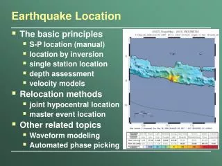
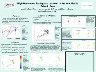
High-Resolution Earthquake Location in the New Madrid Seismic Zone. T51D-0767. Meredith Dunn, Steve Horton, Heather DeShon, and Christine Powell mmdunn@memphis.edu. Data Set and Analysis 1394 Earthquakes 313 Stations Events recorded between 2000-2006

E N D
High-Resolution Earthquake Location in the New Madrid Seismic Zone T51D-0767 Meredith Dunn, Steve Horton, Heather DeShon, and Christine Powell mmdunn@memphis.edu • Data Set and Analysis • 1394 Earthquakes • 313 Stations • Events recorded between 2000-2006 • Double Difference Relocations found for 6 clusters using the program hypoDD (Waldhauser, 2001). Purpose Provide improvement of fault plane resolution through calculation of double difference earthquake locations in the New Madrid Seismic Zone (NMSZ). Clusters 1 and 2 Figure 6: Locations and relocations of clusters 1 and 2 (see figure 3). Cluster 1 is indicated by red circles, cluster 2 is indicated by blue circles. Cross Section is oriented N45E. This arm is thought to be a vertical, right later strike slip fault. Figure 1: Tectonic setting of the NMSZ. Seismicity occurs primarily in the Reelfoot Rift, a possible failed rift system. Red circles indicate earthquakes. Figure 3: Map showing catalog locations with station coverage, as well as major arms of seismicity and 6 clusters relocated in this study. Cluster 5 Figure 7: Locations and relocations of cluster 5 (see figure 3) the northern portion of the central thrust fault. Dip estimated to be 30-32 degrees for relocations, more shallow than southern portion of fault (see figure 8). Cross section is oriented N25W. 4 3 Mississippi Embayment 5 Reelfoot Rift 6 1 2 Cluster 6 Figure 8: Locations and relocations of cluster 6 (see figure 3), the southern portion of the central thrust fault. Dip estimated to be 35-40 degrees, slightly more shallow than original locations. Cross section is oriented N25W. • Study Area • Most seismically active region east of the Rocky Mountains. • Region has history of damaging earthquakes including three M7.0 events in 1811-1812. • Seismicity occurs within Mississippi Embayment, characterized by thick sediment layer at surface. Results and Discussion The NMSZ was divided into 6 clusters based on known tectonics and natural breaks in seismicity. Waveform cross correlation was performed on the entire data set. Results were examined for the NMSZ and for individual clusters. Clustered relocations were more computationally stable and provide more small scale improvements over relocation of the whole NMSZ. Relocations provide a clear image of the fault plane, with improvement over original catalog locations. Future Work Figure 2: Original catalog locations contained in the data set. Color indicates depth of events. The same color legend is used in figures 4 and 5. Figure 5: Results reconstructed from relocation of 6 clusters individually. The depths in several areas such as the northeast and southwest arm are different than those in figures 2 and 4. Figure 4: Results from relocation of entire data set with no clustering performed. These are to be compared with results in figure 5.