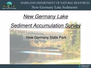
New Germany State Park
220 likes | 372 Vues
New Germany Lake Sediment Accumulation Survey. New Germany State Park. Purpose. DNR has a dual mandate to protect our natural resources and provide recreational use of the lake at New Germany State Park

New Germany State Park
E N D
Presentation Transcript
New Germany Lake Sediment Accumulation Survey New Germany State Park
Purpose • DNR has a dual mandate to protect our natural resources and provide recreational use of the lake at New Germany State Park • Scientific collection of data establishes the foundation for the development of a Lake Management Plan • Interests and concerns of park visitors and neighbors are a vital component of the Plan – Many thanks to the Friends of New Germany for pursuing the issue and actively participating in the process
Agenda • Sediment Sampling (Cores) • Collection and Analysis Procedures • Historical Sediment • Accumulated Sediment • Sediment Chemistry and Pollutants • Headwater Marsh Changes • Sediment Nutrients • Submerged Aquatic Vegetation Control • Management Options
New Germany Lake Timeline • Colonial Period – 9-15 foot channelized stream (Poplar Lick Run) • 1837-1847 – Swauger Mill Dam was constructed at the same site as the current dam. This created a lake of approximately 9 acres in size. The dam was about 2 feet lower than the current dam. • 1933-1935 – The current earthen dam with a concrete spillway was constructed. This new dam impounded the existing ~13 acres. • 2008 – DNR Engineering & Construction performed maintenance on the concrete spillway, pedestrian bridge and drainage pipe. • 2008 – DNR initiated the current study
Core Sample Location Map • Aerial Imagery is from 2007 • Yellow diamonds are location of cores collected for this study • Core 16 was collected downstream to identify/verify historical soil character
Lake Sediments Valley Deposit Historical Soil Core #3 – South End of Lake Near Current Beach
Lake Water Surface -5 Feet -10 Feet
Sediment Surface -1.5 Feet -3 Feet -4.5 Feet -6 Feet
Lead / Zinc Downcore Trends 1.0 Foot 1.0 Foot 2.0 Feet 3.0 Feet 2.0 Feet 1.0 Foot 3.0 Feet 2.0 Feet Lead and Zinc atmospheric and sediment concentrations increased in the early 1900s due to coal-powered factories, power generation, and the automobile. The increase of Lead and Zinc concentrations in the uppermost sediments imply that the sediments shallower than 0.5-1 feet are more recent than 1900, and the sediments deeper than 0.5-1 feet are older than 1900.
Total Sediment Accumulation within Current Shoreline • The average accumulated sediment thickness is 2.6 feet. • 76% of all existing sediment in the lake was deposited in the first 60+ years of the lake’s history (1840-1900) • 24% of all existing sediment in the lake accumulated in the last 108 years (1900-2008).
Chemical Analysis of Sediment • 30 samples throughout the lake and at different sediment depths were analyzed for their elemental composition. • No significant elemental enrichments were detected. • Three Samples (Core #s 1,11,15) were analyzed for semi-volatile organic pollutants and pesticides. • No pesticides or semi-volatile organic pollutants were detected.
The Wetland is an Important Environmental Feature of New Germany Lake. • Sediment Trap • Nutrient Sink • Natural Habitat
Headwaters Marsh Changes • Aerial Imagery is from 2007 • Blue line is shoreline from 1946 USGS Topographical Map
Headwaters Marsh Changes Distances measured from multiple maps / images from the Marsh shoreline to Twin Oaks Road 349-330 meters 39 years =0.5m/yr Swauger Dam 238-202 meters 69 years =0.5m/yr Current Dam Maps and Imagery show that the New Germany Lake Headwaters Marsh Shoreline has been growing at a rate of 0.5 meters per year (1.6 ft per year) since its establishment.
Surface Sediment • 8 samples collected in April 2010 • Elemental Analysis showed the same as Core Samples (no significant enrichments) • Nutrient Analysis shows slightly enriched levels of Nitrogen.
Historic data on the composition and growth of the SAV population in New Germany Lake is not available. Experience with deeper mountain lakes indicates that SAVs are found at water depths greater than the original water depths of New Germany Lake. There is no reason to believe that the decrease in lake depth caused by sediment deposition has increased the SAV growth.
SAV Control Options: • Aquatic Herbicides • Biological Control Agents • Mechanical Harvesting • Winter Draw Down (Root Freezing)
Summary • Sediment Accumulation Over the course of its ~170 year history, New Germany Lake has accumulated a maximum of 1.8 to 3.8 feet of sediment thickness throughout the majority of the lake, with most sediment accumulating in the northern portion of the lake. Environmental indicators show that a majority of this accumulation (76%) occurred before the early 1900s. Sediments that have accumulated since 1900 range in depth from 3-5 inches. • Headwaters Marsh Growth The delta formed in the headwaters of the lake has shown a consistent history of growth at 1.6 feet/year. • Sediment Chemistry No forms of sediment pollution were identified. Slightly elevated levels of Nitrogen were detected in the surface sediments. • Submerged Aquatic Vegetation SAV Growth has increased as the lake matured. The population currently inhabiting the lake includes native species that enhance aquatic habitat.
Management Options • Periodically monitor incoming sediment and marsh growth to determine if rates of deposition or growth have changed. • Continue regular control program for Submerged Aquatic Vegetation (SAV) – This would not affect sedimentation rate but would reduce extent of SAV beds. • Remove accumulated sediment from the lake or selected portions (includes dewatering facility) – Cost estimates are between 2-5 million dollars. Lake would be closed for a year or more. • Remove accumulated sediment from upper end of lake – Removal of the existing natural wetland would result in significant ecological impacts and involve complex wetland permitting and mitigation issues. • Explore management options to slow the current rate of growth in the headwaters marsh
Ranger Mary Ironside • Mironside@dnr.state.md.us • Dnr.maryland.gov/publiclands/western/newgermany.asp