Interactive Campus Map (ICM)
Internal Design Review 2/26/09 ARMS 1098B. Interactive Campus Map (ICM). Office of the Dean of Students. TRW ODOS. 1. Introduction of the team. Project members Rachel Tenbarge Project leader Zach Cassiday Project member Jason Lee Project member. ICM.

Interactive Campus Map (ICM)
E N D
Presentation Transcript
Internal Design Review 2/26/09 ARMS 1098B Interactive Campus Map(ICM) Office of the Dean of Students TRW ODOS 1
Introduction of the team Project members Rachel Tenbarge Project leader Zach Cassiday Project member Jason Lee Project member ICM Insert picture here of team working on the big campus map. 2
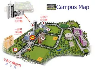
Project History The project partner needed an easily accessible computer mapping system to allow for the easy travel of students, faculty, and visitors of Purdue University who have disabilities. Project was completed in 2005 but kiosk was brought back for maintenance ICM 3
Current Project Description What is the ICM? A program that provides printouts of shortest accessible routes from building to building. Why is the ICM useful? People with disabilities can acquire direction easily. Visitors new to campus can get directions. Students can access it online for directions at any time. ICM 4
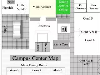
Software Overview Code written in C++, Perl, HTML. Program utilizes pixel coordinates from a picture of the campus map (designated as nodes) to determine the best path from the start location to the end. Once the best path is determined it displays a campus map and overlays the appropriate path onto it.
Program Issues • File storage • Program creates a new data file at every run • Current map is outdated • The nodes (example below) are all initialized in a single database file: MSEE-EE 10 3734.738, 3856.882 9,11,16
Kiosk Issues • Kiosk is an interactive housing unit with a touch screen to run ICM wirelessly • Wireless currently not working • Unit runs an outdated version of the program • Needs to print a map with user’s travel path • Hard to line up the printer with the paper slot dispenser • Paper falls to the floor when it is printed (no hold tray)
Semester Goals & Progress Include all accessible doors of all major buildings on campus (Completed: ~ 8.5 days time) Means walking around every building on campus Requires taking a map and plotting each accessible door Transfer all existing nodes (Completed: ~ 4 days time) Old database nodes on a smaller map for reference New database nodes on a bigger map for readability and elimination of unneeded nodes ICM 10
Semester Goals & Progress Developed integrated team system to work on database nodes at the same time Plot shortest accessible paths from destination to destination (In progress: ~ 9 days time…and counting) Create all new nodes on new campus map Plot all “neighbor nodes” Run algorithm which calculates shortest path ICM 11
Semester Goals & Progress For each new node calibrate exact pixel location(In progress: Estimate 40-65 man hours to complete) Currently 600 nodes to calibrate Begin with old node location and manually compare new node to old node Takes approximately 4 minutes to place one node Traverse all combinations of possible paths(Not started: Estimate 130 man hours to complete?) Fix paths that may go through buildings ICM 12
Future plans Release ICM prototype for field testing within 1-2 weeks Fix kiosk structural issues and find permanent housing location for kiosk Hopefully to be completed while field testing is being conducted Revisions based on project partner feedback Complete final project by April 2009 ICM
Internal Design Review 02/26/09 ARMS 1098B Adjustable BookshelfABS Office of the Dean of Students TRW ODOS 15
DigiKey SPST micro switch Top: New Track Actuator Bottom: Old Linear Actuator Status Summary ABS • Expected usable prototype delivery: April 2, 2009 • Purpose: receive feedback from actual use • Expected features at that date: • Full range of vertical motion • Safety sensor • Prototype wood surfaces • Partial User Manual • Final cost: ~$320 • Reduction possible if creating multiple shelves
Progress of current shelf Progress ABS • Track actuator installed • System circuitry design and troubleshooting • Purchase of electrical components • Microswitches • Limit switches • Relays • Power Supply • Safety sensors, limit switches in place; not wired
Attention Areas ABS • Problem: Complicated motor circuitry • Solution: Troubleshooting, new diagrams, purchase of a different part • Implications: None • Problem: Shelf and track actuator mounting • Solution: Correct mistakes made • Implications: None • Problem: Shelf size • Solution: Reviewed goals and deemed immediate resizing unnecessary • Implications: Shelf re-sizing will be done after circuitry testing; no change in expected delivery date
Technology ABS Solved: • Circuitry: simplified, modular sensor circuitry • Able to be updated • Objects able to be added To be solved: • Removal of top of shelf • Problems mounting track actuator • Official delivery date will be delayed • Mounting of safety switch plate • So as to not limit switch capabilities • Will not meet project goals • Options: weather stripping, molding, wire ties and hooks Shelf re-design with removal of shelf top
Goals for Next Review ABS • Next status update: Brief Memo on March 6 • Directly before testing with potential users • Next review: April 2 • Design review date • Directly before prototype delivery date • Upcoming goals: • Safety sensors and warnings (03/05) • Shelf stabilizers (03/05) • New actuating buttons (03/26) • Re-sized shelf with top removed (03/26) • User manual outline (04/02)
Internal Design Review 02/26/09 ARMS 1098B Global Positioning System Device for the Visually Impaired(GPS-DVI) Office of the Dean of Students TRW ODOS 21
Status Summary • Project kind of behind because of a project redesign. • Final delivery date is set for Spring 2010. • Overall the project should cost about $250 per handheld GPS device. • eTrex Legend Hcx, MicroSD chip, batteries
Progress • Project went through a redesign. • Specific routes were inefficient so we are redesigning. • Individual tours will guide students around campus. • Went out and collected many different waypoints and intersections around campus. • Created a handful of routes as part of original project design.
Attention Areas • Over 70,000 routes needed to be created by hand • Too time consuming and inefficient so redesign was needed • Should still be on track since we underestimated the amount of time for old project • Nodes and Intersections • There are hundreds of waypoints and intersections that need to be added. • Should be finished adding Nodes and Intersections to our map within a week
Technology • Able to create routes on our mapping system with available waypoints and intersections. • Still unable to add map to our mapping system • Every waypoint and intersection must be added by going to the specific point with the eTrex. • GPS dependent • GPS is inaccurate at times • Inaccurate points are removed and have to be plotted again.
Goals for Next Review • Design Review is on Thursday, April 2nd • Goals • Main Campus tour routes are created and tested to be accurate. • Nodes and intersections of residence halls and buildings south of State Street are added. • New tour routes of Discovery Park and the Residence Halls are created and tested. • Think of ways to make GPS device accessible for students with visual impairments.