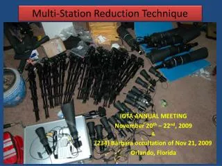
ALTM Orion Multi-Station Sensor Mount
190 likes | 298 Vues
ALTM Orion Multi-Station Sensor Mount.

ALTM Orion Multi-Station Sensor Mount
E N D
Presentation Transcript
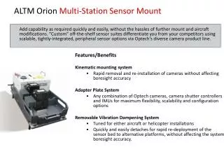
ALTM Orion Multi-Station Sensor Mount Add capability as required quickly and easily, without the hassles of further mount and aircraft modifications. “Custom” off-the-shelf sensor suites differentiate you from your competitors using scalable, tightly-integrated, peripheral sensor options via Optech’s diverse camera product line. Features/Benefits Kinematic mounting system • Rapid removal and re-installation of cameras without affecting boresight accuracy Adapter Plate System • Any combination of Optech cameras, camera shutter controllers and IMUs for maximum flexibility, scalability and configuration options Removable Vibration Dampening System • Tuned for either aircraft or helicopter installations • Quickly and easily detaches for rapid re-deployment of the sensor bed to alternative platforms, without affecting the system boresight accuracy.
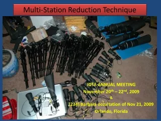
ALTM Orion 2-Station Mount • T-7200/4800/MS (1) centered to lidar FOV for small sensor portals • T-7200/4800/MS (1) + external IMU • T-7200 (1) + T-MS/4800 (1) • D-8900 (1) + shutter controller box
ALTM Orion 4-Station Mount • T-7200(2) + 4800/MS (1) + external IMU • T-7200 (1) + T-MS/4800 (2) + external IMU • T-7200/4800/MS (1) + oblique T4800 (1) + external IMU • D-8900 (2) + shutter controller box (2) • D-8900 (1) + shutter controller box (1) + 4800/MS (1) + external IMU • D-8900 (1) + shutter controller box (1) + 4800/MS (2) • T-7200/4800/MS (2) + oblique T4800 (1)
6 – Station Mount ALTM Orion M-300 Multi-Spectra camera Oblique forward looking camera Oblique rear looking camera RGB 80 MP Nadir camera Future thermal camera
Presentation Overview • ALTM Orion: High Precision Mapping System • Market fitment; Features/Benefits • Performance Specifications • Product Configuration and Peripherals (Data storage; Cameras & Mounts; Waveform Digitizers) • Workflow (ALTMnav, Optech Lidar Mapping Suite)
Workflow Complete solutions for mission planning, sensor operation and XYZ point cloud generation (LAS format)
Spring 2012: All new Optech FMS • Real-time lidar data display (elevation/intensity/swath extents) • Real-time lidar data stored to LAS; camera thumbnails stored to file for in-air review • Photo frames projected to surface • Multi-camera trigger by fixed geographic position and/or fixed time • Automated digitizer trigger control and monitoring • Layered diagnostics
Optech FMS - Plan • Wide area and corridor • Active and passive sensor planning (dependent and independent) • Independent flight line optimization • Digitizer planning • DEM planning (gap analysis, eye safety violations, etc.) • Camera trigger by geographic fixed position and fixed time • Photo index plots
Optech LMS™ – Lidar Mapping Suite • Features/Benefits • High-efficiency production processing suite • Performance enhancements: parallel, distributed, batch, multi-sensor, multi-mission • Automated lidar rectification • Accuracy analysis: pre/post rectification, relative/absolute, graphs/plots/rooflines/reports • Coordinate conversion (Blue Marble Geographics)
Primary Software Objectives • To develop a lidar rectification package that maximizes data accuracy for the entire mission and/or project using available lidar data redundancy • Software that is fully automated and production-workflow oriented • Ability to quantify relative and/or absolute accuracies in a variety of reporting formats for the entire mission and/or project • To leverage the proprietary IP associated with Optech’s optical models for maximum accuracy.
User Expectations End Users and Decision Makers • Lidar lives beyond project • Information has to be: • Simple • Accessible • Timely Application and data integration is critical
User Expectations: Simple End Users and Decision Makers • Single interface • Zoom/Roam/Search • Visualize data • Perform analysis • Discover relevant information
User Expectations: Accessible End Users and Decision Makers • Accessible with other data • Imagery • Base Maps • Operational Layers • Internally within your organizations and online
User Expectations: Timely End Users and Decision Makers ArcGIS enables timeliness by • Using server based on-the-fly processing • Automated analysis and geoprocessing • 2D and 3D visualization
The Lidar Workflow Manage Collect and Integrate Visualize and Analyze Share
Thank you, Jim Green, CST jim.green@optech.com