Download

1 / 25
250 likes | 400 Vues
Supercomputing at Croatian Hydrological and Meteorological Service Antonio Stanesic. Outline. General information Croatia supercomputers Usage of DHMZ supercomputer Viking OU – DHMZ collaboration. Croatia. 56,542km 2 4,5 million inhabitants. Croatia. DHMZ.

E N D
Supercomputing at Croatian Hydrological and Meteorological Service Antonio Stanesic
Outline General information Croatia supercomputers Usage of DHMZ supercomputer Viking OU – DHMZ collaboration
Croatia 56,542km2 4,5 million inhabitants
DHMZ DHMZ – Croatian Hydrological and Meteorologica Service fundamental institution for meteorology and hydrology in Croatia founded by decree of Government of People’s Republic of Croatia (NRH) on 27th of August 1947 the number of employees increased to reach a stuff of more than 440
Croatia - supercomputers Isabella – located at University Computing Centre (SRCE) 100+2 servers 352 CPU cores on compute nodes 544 GB RAM memory 8 TB local disk space additional disk space at main SRCE's disk space (SAN - Storage Area Network) with total capacity up to 40 TB
Croatia - supercomputers Viking – located at DHMZ SGI Altix LSB-3700 BX2 Server 48 Intel Itanium2 1.6GHz/6MB 96 GB standard system memory, 2x146 GB/10Krpm SCSI disk drive OS SUSE Linux Enterprise Server 9 for IPF with SGI Package Intel Fortran & C++ compilers version 9.0.031 Queuing system (PBS Pro) 7 TB of storage place available and ongoing implementation of 30 TB of disk space
Supercomputing at DHMZ Operational 72h forecast Research activities: Data assimilation Case studies Climate model Chemical transport model Downscaling of ECMWF reanalysis
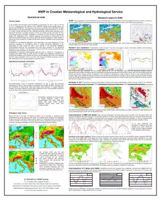
General information - NWP in Europe At the moment there are 5+1 NWP Consortia in Europe: ALADIN- Aire Limitée Adaptation dynamique Développement InterNational (Algeria, Belgium, Bulgaria France, Morocco, Poland, Portugal, Tunisia, Turkey) COSMO- COnsortium for Small-scale Modeling (Germany, Switzerland, Italy, Greece, Poland, Romania) HIRLAM- HIgh Resolution Limited Area Model (Denmark, Estonia, Finland, Iceland, Ireland, The Netherlands, Norway, Spain, Sweden) UK Met Office ECMWF- European Consortium for global model RC-LACE- Regional Cooperation for Limited Area modeling in Central Europe (Austria, Croatia, Czech Republic, Hungary, Slovakia, Slovenia, Romania) => DHMZ (Croatia) is member of ALADIN and RC-LACE Consortiums
About models in ALADIN World ARPEGE – global spectral model ALADIN – NH/H regional NWP model developed for scale ~ 10 km Mezo-NH – NH mesoscale atmospheric model of the French research community AROME – NH mesoscale NWP model with advanced physics for nowcasting and very short range forecasting. Dynamical kernel – NH ALADIN and physical parameterization package of the Meso-NH for ~2 km resolution ALARO (is not a model) – improved version of ALADIN: new radiation scheme, horizontal diffusion, microphysics, TKE; mostly developed by RC-LACE
Operational forecast LBC – ARPEGE (global model); runs at Meteo-France ALARO – regional model 8km horizontal resolution hydrostatic 37 levels (229x205) 240x216 grid points 72 hour forecast;1-3 hourly output DADA – dynamical adaptation 10m wind forecast, 450x450gp, 15 levels (lowest 17m) below 1km
DADA To make integration with smaller number of levels and only part of physical parameterizations (vertical diffusion and influence of gravity waves) to adjust flow to better orography until quasi stationary state
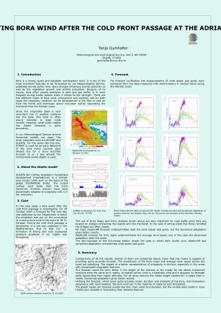
DADA More details in flow (stronger flow behind mountain Velebit)
DADA Comparison with measurements
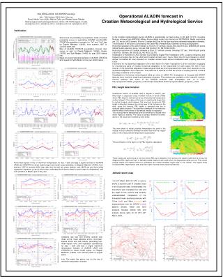
Operational forecast Operational production (00 and 12 UTC): Downloading of LBC files (ARPEGE) Interpolation of fields to finer resolution ALARO Integration Visualization of meteorological fields: surface charts, pressure levels charts and vertical cross-sections (in time and space) Change of the resolution 8 to 2 km DADA - Adaptation of the wind field (Integration) at 2 km Visualization of the 2 km resolution wind field forecast
Operational forecast Top time consuming applications on supercomputer Viking Downloading of the LBC files ~ 30 minutes (done at 03:25 and 15:00 UTC) Integration at 8 km (20 processors) ~ 40 minutes (done at 03:40 and 15:20 UTC), Dynamical Adaptation of the wind field (Integration) at 2 km with 3 hrs time resolution (20 processors) (done at 04:25 and 16:00 UTC) Continuation of the Dynamical adaptation for 1 hr time resolution (extra 1 hour done at 05:25 or 17:00) For operational usage most of the time less than 5 hours per day is sufficient.
ALARO Most important public users Air traffic control – HKZP Military – MORH National Protection and Rescue Directorate -112- DUZS Forecast department in DHMZ Hail protection department in DHMZ Forest fire forecast for DHMZ Road authorities- HC wind fcst Electrical company- HEP Nuclear Safety Agency- DZNS TV’s- public & private Mobile phone providers Internet- free public forecasts
Research: EMEP4HR Monthly maximum surface ozone fields (in PPBV) for May The Unified EMEP model is coupled to ALARO meteorological output and run on 10km resolution. This model setup called EMEP4HR is used for air quality studies in DHMZ
EMEP4HR In the first case maximum ozone is increased while in the other it is decreased by approximately 1% in the area with very high traffic emissions. This study is made for the purposes of the Ministry of construction and environment of Croatia. Example: Part of a study made to determine the influence of industrial and traffic emissions on ozone Relative effects of 15% increase(left) and 15% decrease(right) of traffic based NOx and VOC emissions.
Research: Data assimilation 3DVar data assimilation for upper air fields and OI for surface fields in ALARO model Observations used: Synop, Temp, Aircraft, AMV, Wind profiler, Satellite (ATOVS AMSU-A,B,HIRS(NOAA), SEVIRI) External observation preprocessing - Hungary Local set up of assimilation cycling and production
Research: Data assimilation Statistics for operational (oper) and production from 3dvar (3dvar) calculated against synop and temp observations (2m fields)
Plans and needs Plans (Research and Development Division): Turn on more sophisticated physical package already available for ALARO Operational assimilation Increase number of vertical levels Increase horizontal resolution Assimilate more data Needs: More CPU power More storage place
OU - DHMZ collaboration Contract between University of Oklahoma (OU) and Meteorological and Hydrological Service of Croatia (DHMZ) on Feasibility Study for the Meteorological and Hydrological Service Modernization Project in the Republic of Croatia Optimize the overall HydroMet system modernization plan in Croatia Study Team: Primary Authors: Dr. Keith A. Brewster, Dr. Kenneth C. Crawford, Mr. James E. Hocker, Dr.Renee A. McPherson, Mr. William G. McPherson Jr., Ms. Kodi L. Nemunaitis, Dr. MarijanaSumpor, and Dr. Daniel Sutter Contributors: Ms. Kara Bolognini, Mr. Donald W. Burgess, Dr. Boon Leng Cheong, Mr. Leslie R. Lemon, Dr. Donald R. MacGorman, Mr. Dale A. Morris, Mr. B. David Sherman, and Ms. Ellen J. Wardrop
OU - DHMZ collaboration Some recommendations from Study Team: Establish DHMZ headquarters of weather and water research and operations in a modern, high-technology facility Significantly enhance the DHMZ IT infrastructure Modernize and expand the DHMZ network of Doppler radars Establish an integrated surface observing network for weather, water, and climate observing that provides high-quality data in real-time Establish a verification unit to demonstrate the ski( of modernized operations and to identify new opportunities for research and development Invest in the workforce to operate and thrive in a modernized DHMZ by providing positions for highly educated professionals, a salary structure appropriate for a highly educated and technology-driven workforce, and intensive instructional programs to re-educate the workforce