Download
1 / 1
20 likes | 186 Vues
FORECASTING BORA WIND AFTER THE COLD FRONT PASSAGE AT THE ADRIATIC COAST. Tanja Gumhalter. Meteorological and Hydrological Service, Grič 3, HR-10000 Zagreb, Croatia gumhalter@cirus.dhz.hr. 1. Introduction. 4. Forecast.

E N D
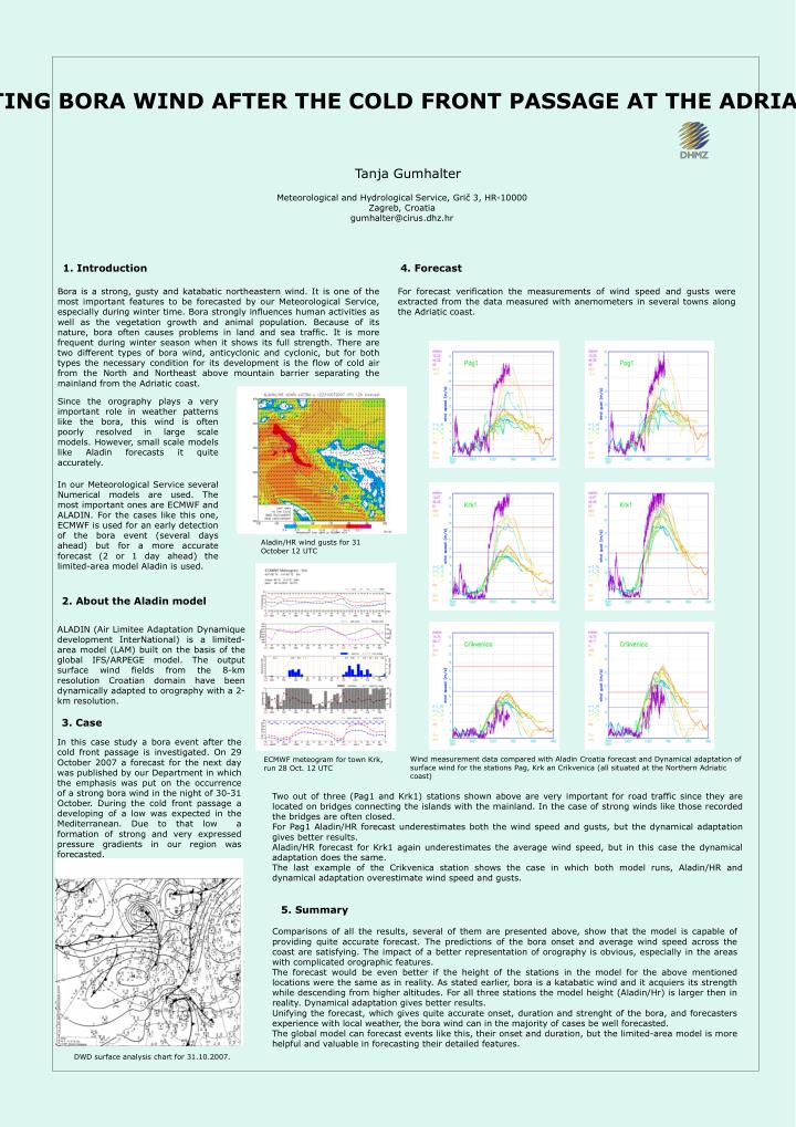
FORECASTING BORA WIND AFTER THE COLD FRONT PASSAGE AT THE ADRIATIC COAST Tanja Gumhalter Meteorological and Hydrological Service, Grič 3, HR-10000 Zagreb, Croatia gumhalter@cirus.dhz.hr 1. Introduction 4. Forecast For forecast verification the measurements of wind speed and gusts were extracted from the data measured with anemometers in several towns along the Adriatic coast. Bora is a strong, gusty and katabatic northeastern wind. It is one of the most important features to be forecastedby our Meteorological Service, especially during winter time. Bora strongly influences human activities as well as the vegetation growth and animal population. Because of its nature, bora often causes problems in land and sea traffic. It is more frequent during winter season when it shows its full strength. There are two different types of bora wind, anticyclonic and cyclonic, but for both types the necessary condition for its development is the flow of cold air from the North and Northeast above mountain barrier separating the mainland from the Adriatic coast. Since the orography plays a very important role in weather patterns like the bora, this wind is often poorly resolved in large scale models. However, small scale models like Aladin forecasts it quite accurately. In our Meteorological Service several Numerical models are used. The most important ones are ECMWF and ALADIN. For the cases like this one, ECMWF is used for an early detection of the bora event (several days ahead) but for a more accurate forecast (2 or 1 day ahead) the limited-area model Aladin is used. Aladin/HR wind gusts for 31 October 12 UTC 2. About the Aladin model ALADIN (Air Limitee Adaptation Dynamique development InterNational) is a limited-area model (LAM) built on the basis of the global IFS/ARPEGE model. The output surface wind fields from the 8-km resolution Croatian domain have been dynamically adapted to orography with a 2-km resolution. 3. Case In this case study a bora event after the cold front passage is investigated. On 29 October 2007 a forecast for the next day was published by our Department in which the emphasiswas put on the occurrence of a strong bora wind in the night of 30-31 October. During the cold front passage a developing of a low was expected in the Mediterranean. Due to that low a formation of strong and very expressed pressure gradients in our region was forecasted. Wind measurement data compared with Aladin Croatia forecast and Dynamical adaptation of surface wind for the stations Pag, Krk an Crikvenica (all situated at the Northern Adriatic coast) ECMWF meteogram for town Krk, run 28 Oct. 12 UTC Two out of three (Pag1 and Krk1) stations shown above are very important for road traffic since they are located on bridges connecting the islands with the mainland. In the case of strong winds like those recorded the bridges are often closed. For Pag1 Aladin/HR forecast underestimates both the wind speed and gusts, but the dynamical adaptation gives better results. Aladin/HR forecast for Krk1 again underestimates the average wind speed, but in this case the dynamical adaptation does the same. The last example of the Crikvenica station shows the case in which both model runs, Aladin/HR and dynamical adaptation overestimate wind speed and gusts. 5. Summary Comparisons of all the results, several of them are presented above,show that the model is capable of providing quite accurate forecast. The predictions of thebora onset and average wind speed across the coast are satisfying. The impact of a better representation of orography is obvious, especially in the areas with complicated orographic features. The forecast would be even better if the height of the stations in the model for the above mentioned locations were the same as in reality. As stated earlier, bora is a katabatic wind and it acquiers its strength while descending from higher altitudes. For all three stations the model height (Aladin/Hr) is larger then in reality. Dynamical adaptation gives better results. Unifying the forecast, which gives quite accurate onset, duration and strenght of the bora, and forecasters experience with local weather, the bora wind can in the majority of cases be well forecasted. The global model can forecast events like this, their onset and duration, but the limited-area model is more helpful and valuable in forecasting their detailed features. DWD surface analysis chart for 31.10.2007.