AMSU-A Geolocation
AMSU-A Geolocation. Thomas J. Kleespies NOAA/NESDIS/ORA 9 August 2005. AMSU-A over Red Sea. 1) AMSU-A2 channel 1 23.7GHz 2) AMSU-A1/2 channel 3 50.3 GHz 2) AMSU-A1/1 channel 15 89.0 GHz Animation reveals a shift between the A2 and A1 Which is correct?. Chan 1&3 Animation

AMSU-A Geolocation
E N D
Presentation Transcript
AMSU-A Geolocation Thomas J. Kleespies NOAA/NESDIS/ORA 9 August 2005
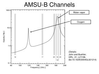
AMSU-A over Red Sea • 1) AMSU-A2 channel 1 23.7GHz • 2) AMSU-A1/2 channel 3 50.3 GHz • 2) AMSU-A1/1 channel 15 89.0 GHz • Animation reveals a shift between the A2 and A1 • Which is correct?
Chan 1&3 Animation View in Slide Show Go to another slide to stop Chan 1&15 Animation View in Slide Show Go to another slide to stop
Chan 1&15 Animation View in Slide Show Go to another slide to stop
Chan 3 &15 Animation View in Slide Show Go to another slide to stop
Ascending/Descending node brightness temperature difference • Makes use of the fact that ascending node views are mostly daytime (surface hot) and descending node views are mostly nighttime (surface cold), but ocean surface temperatures unchanged • Brightness temperatures binned and averaged for each node in 0.5x0.5 deg lat-lon boxes • Asc minus Des node brightness temperatures differenced and displayed. • If there is an alongtrack negative offset, northern coastlines will have a cold edge, and southern coastlines will have a warm edge. • If there is a negative crosstrack offset the western coastlines will have a cold edge and the eastern coastlines will have a warm edge • The reverse of the above is also true • Zoom in to Europe clearly demonstrates this
Eastern Coastline Northern Coastline Western Coastline What we mean by northern southern, eastern and western coastlines Southern Coastline AMSUA18 05152-05172 Channel 1
Eastern Coastline Northern Coastline Western Coastline Southern Coastline AMSUA18 05152-05172 Channel 15
Zoom in on Europe AMSU-A2 appears to be geolocated negative alongtrack and negative crosstrack South Warm East Warm North Cold West Cold AMSUA18 05152-05172 Channel 1
Zoom in on Europe AMSU-A1-2 appears to be correctly geolocated No Obvious Red/Blue coastlines
Zoom in on Europe AMSU-A1 appears to be geolocated slight positive alongtrack and slight positive crosstrack Hint of South Cold Hint of East Cold Hint of North Warm Hint of West Warm AMSUA18 05152-05172 Channel 15
Conclusions • AMSU-A1/1 appears to be geolocated slight positive alongtrack and slight positive crosstrack • AMSU-A2 appears to be geolocated negative alongtrack and negative crosstrack • AMSU-A1/2 appears to be geolocated correctly • Unknown whether it is pointing or navigation • Bennartz study will refine magnitude of offset.
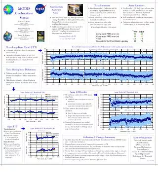
MHS Geolocation Thomas J. Kleespies NOAA/NESDIS/ORA 9 August 2005
MHS over Red Sea • MHS channel H1 89GHz • MHS appears to be shifted several pixels alongtrack • Closeup reveals it to be approximately 1-2 pixels
Zoom in on Red Sea/Gulf of Aden MHS CHANNEL 1 JUNE 13
Ascending/Descending node brightness temperature difference • Makes use of the fact that ascending node views are mostly daytime (surface hot) and descending node views are mostly nighttime (surface cold), but ocean surface temperatures unchanged • Brightness temperatures binned and averaged for each node in 0.5x0.5 deg lat-lon boxes • Asc minus Des node brightness temperatures differenced and displayed. • If there is an alongtrack positive offset, northern coastlines will have a warm edge, and southern coastlines will have a cold edge. • Zoom in to Europe clearly demonstrates this
Northern Coastline Southern Coastline Northern Coastline What we mean by northern and southern coastlines Southern Coastline
South Cold South Cold North Warm South Cold North Warm North Warm Zoom in on Europe
Conclusion • MHS geolocation is mislocated in positive alongtrack direction 1-2 pixels • Unknown whether it is pointing or navigation • Bennartz study will refine magnitude of offset.
Preliminary Results of Bennartz StudyCorrection necessary to match coastlines * * * * * Confirms above results
AMSU-A Scan Biases Thomas J. Kleespies 9 August 2005
Methodology • June 1 – June 22 • Earth scene brightness temperatures binned as function of scan position • 40N – 40S • Ocean only (avoiding coastlines as well) • Precipitation screening using Grody Algorithm • Mean brightness temperatures differenced pairwise left – right • Ascending: solid line, descending: dashed line
Conclusions • A2 left side appears warmer than right side • A1 right side appears warmer than left side by ~ 1 deg – varies by channel • Window channels display ascending/descending disparity • Sounding channels ascending/descending behavior consistent
MHS018MHS Scan Biases Thomas J. Kleespies 9 August 2005
Methodology • June 1 – June 22 • Earth scene brightness temperatures binned as function of scan position • 40N – 40S • Ocean only (avoiding coastlines as well) • Precipitation screening using Grody Algorithm • Mean brightness temperatures differenced pairwise left – right • Ascending: solid line, descending: dashed line
Conclusions • Window channels ambiguous: ascending and descending portions of orbit have opposite signature • Sounding channels show a slight bias (few tenth degree) with the right side being warmer