Download
1 / 38
380 likes | 523 Vues
Neuse River Prototype Observatory. Jay Famiglietti for the Neuse Prototype Design Team Logan, Utah August 24, 2004. Neuse Prototype Team. · Dr. Ken Reckhow, UNC-WRRI (water quality); Team Leader · Dr. Chris Duffy, Penn State (hydroclimatology/sat-unsat)

E N D
Neuse River Prototype Observatory Jay Famiglietti for the Neuse Prototype Design Team Logan, Utah August 24, 2004
Neuse Prototype Team ·Dr. Ken Reckhow, UNC-WRRI (water quality); Team Leader ·Dr. Chris Duffy, Penn State (hydroclimatology/sat-unsat) ·Dr. Jay Famiglietti, UC-Irvine (atmosphere-land interactions) ·Dr. David Genereux, NC State (groundwater-surface-water interaction) ·Dr. John Helly, UC San Diego (information systems) ·Dr. Witold Krajewski, Iowa (hydrometeorology) ·Dr. Dianne McKnight, Colorado-Boulder (biogeochemistry) ·Dr. Fred Ogden, Connecticut (floods/geomorphology) ·Dr. Bridget Scanlon, TBEG (infiltration/vadose zone hydrology) ·Dr. Len Shabman, RFF (economics/social science)
HydroView • Central component of HydroView – a network of hydrologic observatories • Each observatory will be a drainage basin of approximately 10,000 sq. km. • HOs will result in new understanding and theory of hydrologic and related processes as well as an empirical base to test hypotheses.
HOs are to Improve Predictive Understanding in Five Science Topics: • Linking hydrologic and biogeochemical cycles • Sustainability of water resources • Hydrologic and ecosystem interactions • Hydrologic extremes • Fate and transport of chemical and biological contaminants
Each of the Science Topics can be addressed by Three Cross-Cutting Themes: • Forcing, feedbacks, and coupling • Scaling • Prediction and limits to predictability
Four Basic Properties of a Catchment • Mass in each “store” Water, sediment, nutrients, contaminants • Residence time within stores • Fluxes between stores • Flowpaths among stores
Conceptual framework of HO watershed: Spatially distributed set of stores, fluxes, sources and sinks of water and its constituents (sediment, nutrients, OM, contaminants) organized within a network of hydrologic flowpaths including: • Land surface (land cover, soils) • Surface drainage system (natural/engineered) • Subsurface to include surficial and deep aquifers • Atmospheric boundary layer
Core Data • Monitoring data • Four basic properties • Conceptual model for scaling
Neuse HO Prototype Design • Hydrology and Water Balance • Water Quality • Geomorphology • Social Sciences To assess the feasibility of the HO concept
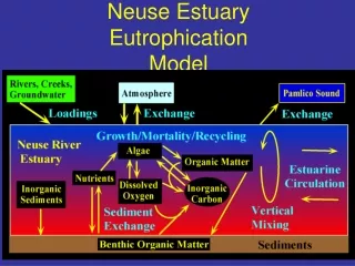
Within the NRB emphasis on water, nitrogen and sediment within: • Topographically driven surface (hillslope) drainage paths, • Subsurface stores and flowpaths (vadose and phreatic), • Network of stream and river channel reaches, surface water bodies including lakes and estuary, • Interface flux between these stores, and between the stores and the atmosphere, and • Human society source/sink of water, carbon and nutrients to these stores and flowpaths • Agricultural irrigation, fertilization, feedlot (CAFO) operations, rapid rotation forestry • Domestic water supply and wastewater
Hypothesis: Framework can be differentiated into subcatchment hydrologic landscape typology describing geomorphic, land cover, climate template. e.g. Piedmont,/Coastal Plain, urban/agricultural, …
Backbone of sampling design includes three sets of coordinated, nested measurement characterizing: • Channel network structure of discharge, solute flux and transformations, sediment mobilization and routing, at order of magnitude drainage areas • land surface sources/sinks of water, energy, nutrients and sediment, measured at a set of land-atmosphere (LA) instrumented sites along representative flowpaths of hydrologic landscapes contributing to the stream gauges, and • multi-resolution precipitation and ABL measurements with high resolution precipitation available for smaller, focal catchments
Upper Neuse subcatchment land use:nested observational design Currently 42 operational USGS SW gauges in Neuse to be augmented with additional gauges: Small, medium and large catchments (e.g. 0.1, 1, 10, 100, 1000 km2) gauged in different hydrologic landscapes Colocate within stream measurements of sediment/nutrients at the station or adjacent reaches ETR arrays installed in riparian zone and adjacent hillslopes Nested precipitation measurement network
ETR (EvapoTranspiration, Recharge) sites within hydrologic landscape flowpath positions
Precipitation measurement: Nested precipitation gauge, doppler radar, disdrometer network
Example Research Questions • Is the relationship between rainfall and runoff changing in the Neuse watershed, and if so, where and by how much? What are the implications for future flooding and low flow under likely climate change scenarios? • How does river discharge per unit contributing area (Q/A) vary with spatial scale along the Neuse River, from headwaters to coast? What are the main controls on this variation (rainfall, soils, topography, point sources, land use and land cover) and do they change with location/scale? • What is the improvement in predictive performance (outside the calibration period) of watershed hydrologic/nutrient models when data on river/stream discharge at different scales across the full Neuse watershed is used in calibration?
Example Research Questions • Precipitation variability in space and time depends on rainfall regime and intensity. • Precipitation exhibits multiscaling properties conditional on the generating mechanisms, above. • Remote sensing observations of rainfall introduce distorted view of the variability of precipitation. • Errors of radar-rainfall estimates depend on rainfall magnitude, regime, and are interdependent in space and time. The probability distribution of the errors is skewed.
A Neuse HO Should: • support PI research on linkages between biogeochemical cycles and the hydrologic cycle • collect data and carry out analyses designed to quantify hydrologic stores and fluxes of chemical species (complete budgets may require additional PI-driven research…)
Water Quality Measurements in a Neuse HO • surface water (streams, rivers, couple of reservoirs, estuary) & groundwater (shallow unconfined and deep confined) • major ions, nutrients, carbon, metals, pH, DO, suspended solids, chlorophyll A/B/C & accessory pigments (reservoirs and estuary) • goal is to quantify hydrologic stores and fluxes of chemicals
Water Quality Measurements in a Neuse HO (cont.) • measurements at different scales (spatial and temporal), some regular monitoring, some intensive shorter-term campaigns • nitrogen of particular interest, significant pollutant in Neuse (1.4 million people, 2 million hogs, agriculture, fish kills, etc.) • transport and cycling of N are important research topics, linked to hydrologic cycle
Example Research Questions • What are the total hydrologic inputs of N to the Neuse estuary? What are the separate contributions of surface water and groundwater, and the different N species? • How does surface water N transport differ with scale, across the full Neuse watershed and in intermediate size watersheds with different combinations of geology, land use, and topography? How do “natural” transport processes and human effects aggregate and interact to control this variability?
Research Questions (cont.) • How useful is information on N export from small relatively homogeneous watersheds in improving predictive understanding of N export from (and transport within) the full Neuse watershed? • How are groundwater concentrations of different N species, and transport of N from groundwater to surface water, related to groundwater age, past land use, and geology?
HO Would Help PIs Interested in N-Hydrology Linkages • basic data (N concentrations, stores, fluxes) will be available, for surface water (including estuary) spanning range of watershed sizes and geology-land use-topography combinations, and for groundwater of different ages and geological materials, confined and unconfined, Piedmont and Coastal Plain
HO Would Help PIs Interested in N-Hydrology Linkages (cont) • knowledge of hydrologic elements of budgets, PIs interested in closing budgets can focus efforts on other budget terms, or on refinement of hydrologic terms • data sets to support studies of scaling, e.g., how surface water transport differs with scale and why, how to best represent that in models
HO Would Help PIs Interested in N-Hydrology Linkages (cont) • long-term records will allow for study of change over years, analysis of response to forcings (climate change and hydrologic extremes, new regulations on N loading to estuary and groundwater pumping, population growth, land use change)
Remote sensing in the Neuse HO • Hydrologic Observatories provide unparalleled infrastructure to develop/test remote sensing estimates of water storage and flux quantities. • Orbital/airborne RS extensively used in the NW-HO to estimate surface state/flux variables as part of scaling strategies to the full watershed • RS in support of science questions and hypotheses and in development/testing of RS ability to estimate the critical state and flux variables
Major hydrologic variables estimated with RS • soil moisture space/time variability, • surface energy budget terms, • canopy cover, leaf area index and phenology, • flood inundation • water quality parameters • high resolution topographic and land use/land cover patterns and change
Key hydrologic science/technical questions • How can we combine freq, lo res. imaging of veg cover with hi res, infreq imaging to infer spatial/ temporal detail of canopy phenology and cover? • Under what conditions can RS optical, NIR/thermal info be used to estimate ET or evaporative resistance and what are the effects of sensor resolution? • How well can active/passive microwave estimate soil moisture under different topo/veg conditions? Do hi res estimates of soil moisture from active systems aggregate to form soil moisture estimates comparable to lo res passive microwave system estimates?
Hydrologic RS science questions – cont’d • What water quality parameters can be reliably estimated by hyperspectral remote sensing systems? • To what accuracy can high resolution lidar data be used to extract the full stream network along with contributing hillslope drainage flowpaths? • Can airborne lidar be used to study channel and floodplain geomorphic long term trends and transient response to major flood events?
Why Involve The Social Sciences • Observatories are not “experimental watersheds” • Human activities affect stores, flows and fluxes • Document individual and government land and water use choices
Characterizing Human Choices • Amount, timing and location of water withdrawals from streams and aquifers • Amount, location and timing of water retuned to streams and aquifers • Chemical constituents added to the returned water • Distribution of impervious cover types (turf grass, forest, row crops, pasture and animal feedlots) • Management practices on the land in any cover type
Social Sciences Data • Specific-watershed and observatory-wide sample surveys • Continuing activity • Questions modified over time • Different survey procedures (mail, telephone interviews and in person interviews) • Use the Data to Estimate Water and Land Uses at the Appropriate Scales
Summary • Neuse Prototype helps define HO • Identify critical obstacles • Provide guidance on science questions, integrated observing system to address them