Download
1 / 4
40 likes | 184 Vues
Layered Water Vapor Quick Guide by NASA / SPoRT and CIRA. Why is the Layered Water Vapor Product important?

E N D
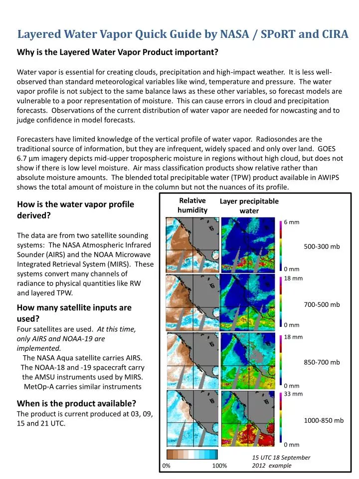
Layered Water Vapor Quick Guide by NASA / SPoRTand CIRA • Why is the Layered Water Vapor Product important? • Water vapor is essential for creating clouds, precipitation and high-impact weather. It is less well-observed than standard meteorological variables like wind, temperature and pressure. The water vapor profile is not subject to the same balance laws as these other variables, so forecast models are vulnerable to a poor representation of moisture. This can cause errors in cloud and precipitation forecasts. Observations of the current distribution of water vapor are needed for nowcasting and to judge confidence in model forecasts. • Forecasters have limited knowledge of the vertical profile of water vapor. Radiosondes are the traditional source of information, but they are infrequent, widely spaced and only over land. GOES 6.7 µm imagery depicts mid-upper tropospheric moisture in regions without high cloud, but does not show if there is low level moisture. Air mass classification products show relative rather than absolute moisture amounts. The blended total precipitable water (TPW) product available in AWIPS shows the total amount of moisture in the column but not the nuances of its profile. Relative humidity Layer precipitable water How is the water vapor profile derived? The data are from two satellite sounding systems: The NASA Atmospheric Infrared Sounder (AIRS) and the NOAA Microwave Integrated Retrieval System (MIRS). These systems convert many channels of radiance to physical quantities like RW and layered TPW. 6 mm 500-300 mb 0 mm 18 mm 700-500 mb How many satellite inputs are used? Four satellites are used. At this time, only AIRS and NOAA-19 are implemented. The NASA Aqua satellite carries AIRS. The NOAA-18 and -19 spacecraft carry the AMSU instruments used by MIRS. MetOp-A carries similar instruments 0 mm 18 mm 850-700 mb 0 mm 33 mm When is the product available? The product is current produced at 03, 09, 15 and 21 UTC. 1000-850 mb 0 mm 15 UTC 18 September 2012 example 0% 100%
How does the product compare to radiosondes? The profiles represent layers of the atmosphere rather than the levels of a radiosonde. Above 850 mb, the accuracy is about 20%. More errors are possible below 850 mb due to surface effects. A great use of the product is to show gradients in water vapor, which is poorly-diagnosed only from radiosondes. Unlike radiosondes, environmental conditions can cause errors in the profile. While these should be screened out, keep ??? What are the things to watch out for? The microwave profiles over land are new and might have seasonal biases. The microwave sounding instruments scan across-track and have less resolution at scan edge, leading to a “blocky” appearance. There is currently no relative humidity over land from MIRS. There is layer precipitable water. The NOAA and MetOp satellites do not sample at regular time intervals. There are no AIRS retrievals below dense clouds, and no MIRS retrievals in precipitating regions. How does the product compare to radiosondes? Unlike radiosondes, environmental conditions can cause errors in the profile. While these should be screened out, keep ??? Resources: The layered water vapor project websitehttp://cat.cira.colostate.edu/sport/layered/ has more information on the project and a variety of global and regional near-real time displays of layer precipitable water and layer RH. The NOAA operational blended TPW site http://www.osdpd.noaa.gov/bTPW/has TPW and TPW anomaly products which can be compared to the less frequent layered moisture products.