Download
1 / 42
450 likes | 869 Vues
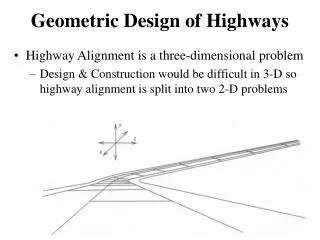
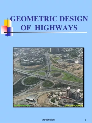
GEOMETRIC DESIGN OF HIGHWAY. Presented By Prof. Omer Maaitah Mutah University. Prof. Omer Maaitah. Definition of Urban and Rural Areas.

E N D
GEOMETRIC DESIGN OF HIGHWAY • Presented By • Prof. Omer Maaitah • Mutah University
Prof. Omer Maaitah Prof. Omer Nawaf Khaled Maaitah
Definition of Urban and Rural Areas • Urban or rural = f (density and types of land use, density of street and highway networks, nature of travel patterns, and the way in which these elements are related) • Urban areas are those places with a population of 5000 or more. 50,000 or more Urbanized areas 5,000 – 50,000 Small urban areas • Rural areas are those areas outside the boundaries of urban areas. Prof. Omer Nawaf Khaled Maaitah
Functional Classification A typical trip includes six stages arranged from higher to lower based on traffic volume: • Main Movement • Transition • Distributor • Collectors • Local Access • Parking Prof. Omer Nawaf Khaled Maaitah
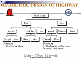
Functional Classification Different classification schemes have been applied for different purposes in different rural and urban regions. Classification by Design Type: Highway Location and Design Procedures Classification by Route Numbering: Traffic Operations Administrative classification: Highway Funding Functional classification: Transportation Planning and Design ASSHTO Green Book is based on the functional classification. One of the first steps in the design process is determining the functional classification of a facility. Prof. Omer Nawaf Khaled Maaitah
Functional System Services Provided Arterial Provides the highest level of service at the greatest speed for the longest uninterrupted distance, with some degree of access control. Collector Provides a less highly developed level of service at a lower speed for shorter distances by collecting traffic from local roads and connecting them with arterials. Local Consists of all roads not defined as arterials or collectors; primarily provides access to land with little or no through movement. Functional Classification Functional Classification is the process by which streets and highways are grouped into classes according to the character of traffic service that they are intended to provide. There are three functional classes: Arterials including freeways Collectors Local Roads Prof. Omer Nawaf Khaled Maaitah
Classification of Roadways • The first question that is asked when a road is built relates to the function that it is going to serve. At the lowest level, there is a local road that provides access to individual housing units in small residential neighborhood. The local roads feed into collector roads that link up multiple neighborhoods. • The collector roads feed into the minor arterial roads, which in turn link to the major arterials that provide connections between large scale community networks. Prof. Omer Nawaf Khaled Maaitah
At the highest level, there are the freeways and expressways that carry regional and intercity traffic. The size of roads in each road class depends on the density of the activities, be it housing, industrial, office, or other activities, as this will have a bearing on the volume of traffic generated. • While the names given to different categories of roads may vary from country to country, in most cases there is an attempt to have a classification system according to function of the roadways. In the United States, the functional classification system of roadways developed by FHWA distinguishes between four classes — local, collector, minor arterial, and principal arterials. The last category is further subdivided into interstate highways, freeways, and expressways. Prof. Omer Nawaf Khaled Maaitah
The ultimate goal of road planning is to ensure safe and smooth flowing traffic conditions through the entire system of roads. While it is important that the roadways must have sufficient capacity to accommodate the traffic demand, it is critical to recognize that road design and management should be undertaken to ensure that the available capacity is not unduly affected by creation of unnecessary bottlenecks and conflicts. Prof. Omer Nawaf Khaled Maaitah
Freeways and expressways are designed for maximum mobility with high speeds and capacities. If there are limited or no controls on the access points to a major freeway or expressway, the capacity, efficiency of travel, and safety levels of the roadway may be compromised. This is why access to the large regional highways needs to be strictly controlled to interchanges spaced many kilometers apart. On the other hand, a local street, which has individual links to adjacent properties cannot be expected to serve a long distance mobility function. With a significant reduced volume of traffic flowing at low speeds, the function of these local roadways is primarily one of access. The remaining roadways, the collectors and arterials serve a mix of access and mobility functions, and the land use and traffic characteristics would largely determine where they are placed between the access – mobility continuum (below mobility vs accessibility). Prof. Omer Nawaf Khaled Maaitah
Express way Prof. Omer Nawaf Khaled Maaitah
Major Arterial Prof. Omer Nawaf Khaled Maaitah
Local Highway Prof. Omer Nawaf Khaled Maaitah
Collector Prof. Omer Nawaf Khaled Maaitah
Mobility and Accessibility of Highway Facilities • Arterials provide a high level of mobility and a greater degree of access control • Collector roadways provide a balance between mobility and land access • Local facilities provide a high level of access to adjacent properties but a low level of mobility Arterials Collectors Local Roads Prof. Omer Nawaf Khaled Maaitah
Mobility and Accessibility of Highway Facilities • Arterials provide a high level of mobility and a greater degree of access control • Collector roadways provide a balance between mobility and land access • Local facilities provide a high level of access to adjacent properties but a low level of mobility Prof. Omer Nawaf Khaled Maaitah
Roles of Functional Classification in Design • AASHTO Green Book establishes the relationships between highway functional classification and design criteria. State, county, and city highway design manuals relate design criteria to highway functional classification. • Once the functional classification of a particular roadway has been established, so has the allowable range of design speed. With the allowable range of design speed defined, the principal limiting design parameters associated with horizontal and vertical alignment are also defined. • Also, the determination of functional classification establishes the basic roadway cross section in terms of lane width, shoulder width, type and width of median area, and other major design features. Prof. Omer Nawaf Khaled Maaitah
Land Use, Urban Sprawl, Highway Classifications • Traffic service patterns on a roadway and the roadway’s function can change over time due to change of land use and urban sprawl. • The functional classification of a highway may be upgraded to a higher lever to reflect the change of traffic service patterns. • Road functions can change over time. Figure (a) shows a new road through the country. Figure (b) shows the first residences along the road. Figure (c) shows suburbanization and the need for mitigation. Prof. Omer Nawaf Khaled Maaitah
Functional Class Design Criteria Interstate New Construction/Reconstruction Standards Principal Arterial New Construction/Reconstruction Standards Minor Arterial 3R Standards Collector Maintenance of Structural Integrity and Operational Safety. Design Standards and Highway Classifications • Functional Classification of a highway facility is often related to the “level of development” or the design criteria that should be applied. • The relationship shown here represents the State of Washington’s table for the relationship. Prof. Omer Nawaf Khaled Maaitah
Ideal Conditions • Minimum lane widths of 12 ft • Minimum right-shoulder lateral clearance between the edge of the travel lane and the nearest obstacle or object influencing traffic behavior of 6 ft • Traffic stream consisting of passenger cars only • Ten or more lanes (5 or more each direction) • Interchanges spaced every 2 mi or more; • Level terrain, with grades no greater than 2 percent; and • Driver population dominated by regular and familiar users of the facility.
Prevailing conditions • The referred to under the Possible Capacity are ideal if • there are at least two lanes for the exclusive use to traffic moves in one direction. • All the vehicle moves under the uniform speed. The driver in U.S.A consider speed at satisfactory if they can move at 45-50 m.p.h. (70-80 km.p.h.)in rural areas and 35-40 m.p.h.(55-65 km.p.h.) in urban areas. The average running speed of the majority of the drivers is however about 5 miles or 8 kilometer per hour less than the above speeds. • There is no commercial vehicle on the road or any other vehicle that is a hindrance to the movement of the smaller vehicles like the passenger cars. • The width of lanes, shoulder and clearance to vertical obstructions beyond the edge of the traffic lean are adequate. • There are no restrictive sight distance, grades, improperly super-elevated curves, intersections or interference by pedestrians.
Traffic capacity • may be defined as the number of vehicles passing at point on the highway in unit time. The subject of highway capacity has been drawing the attention of the all engineers in the world of a number of years .highway capacity varies with the speed and relative interference between vehicles and has little significance unless supplemented by an indication of speed and interference that can be expected . • Before an attempt is made to define highway capacity it is essential to know the difference between highway capacity ,and highway capacity as defined above is the total number of vehicles that can be accommodated on a unit length of the road. • Three definition have been presented for highway capacity in the manual depending upon the prevailing conditions made up of condition determined by (1) the physical features of the road way; and(2) those that are dependant on the nature of traffic using the roadway.
Basic capacity . • The basic capacity of a traffic lane is the maximum number of passenger cars that can pass a given point on a lane or roadway during one hour under the most ideal roadway and traffic conditions that can be attained. It is assumed here that all the vehicles move at the same speed and that the spacing between different vehicles is the minimum .
Possible capacity • The possible capacity is the maximum number of vehicles that can pass a given point on a lane on roadway during one hour under the prevailing roadway and traffic conditions, regardless of their effect in dealing the drivers and restricting their freedom of movement. Composition of traffic ,road alignment ,gradients, number and width of traffic lanes, type of area, vehicles speed and weather etc. Are the major factor that collectively refer to the prevailing conditions, when these prevailing condition is not ideal ,the possible capacity is less than the basic capacity .
Practical capacity • The practical capacity of a traffic lane represent the maximum number of vehicles that can pass a given point6 on a lane o a roadway during one hour without the traffic density being so great as to cause unreasonable delay ,hazard or restriction to the driver 's freedom to manoeuvre under the prevailing roadway and traffic condition . the value of practical capacity is less than that of possible capacity ,the difference is explained like this . at the practical capacity, the traffic density is not high enough to cause unreasonable delay or undue restriction on the driver movements. As the traffic volume increase beyond the practical capacity, traffic density increases sufficiently to cause substantial delay and restriction on drivers movement; however, the resulting lower but uniform speeds of all vehicles enable higher traffic volume to be accommodated up to a value corresponding to possible capacity. The traffic density may increase beyond that of possible capacity but then congestion may set in, speeds drop tremendously and sharp reduction in traffic volume results.
The question arises as to what should be the Design Capacity of the road then? • The design capacity may be defined as the practical capacity or smaller value determined for use in the designing the highway to accommodate the DHV. The values of practical capacity are generally appropriate for the use in design at speeds of 65-70 kilometer per hour (40-45 mph) in rural areas and 50-55 kilometer per hour or 30-35 miles in urban areas (i.e. less by 5 miles than the speeds thought as satisfactory by the drivers). Essentially the same as practical capacity, numerically. Design Capacity, normally is a term applied to a new highways and streets and the practical capacity is a term used in connection with the existing ones.
It has been found in U.S.A. that for two lane highways, both in urban and rural areas, under the ideal conditions the basic capacity is 2000 passenger car per hour in both the directions. The design capacity for a two lane highway where the sight distance on all the points on the road are equal to or more than 500 meter i.e. about 1500 feet; the width of the road is 8 meter (24 feet) and the shoulder clearance is minimum of 2 meter (6 feet) is 900 vehicles. Here, the truck percentage at peak hour has been assumed to be zero and the traffic flow has been assumed as perfect without any interruptions. This is only for the rural roads.
LOS Prof. Omer Nawaf Khaled Maaitah
LOS is the number of vehicle per 1 mile Prof. Omer Nawaf Khaled Maaitah
summary Prof. Omer Nawaf Khaled Maaitah
Functions of roads evolve over time. As a region becomes more intensively built-up, traffic volumes on a major arterial may increase and speeds may be reduced. The building of a new freeway that bypasses these built-up areas to serve through-flow traffic easing congestion may lead to the arterial taking on more of an access function. The development of new major roadways requires a reexamination of the classification system of the region’s entire road network and some displacement of roads from their original classes may be necessary. The changes in the categorization of roads provide useful opportunities for the redistribution of traffic so that the functional integrity of the entire road system is structurally sustained. A long term land-use transport plan should be developed to determine not only the functional class of a particular roadway but also to establish the estimated life of that roadway within the class. An area may avoid expensive modifications of existing roadways to sustain its functional position within a particular class if it is clear from the long-term plan that the roadway may be displaced to an access function when a proposed new roadway is built later on. In the process, planners also avoid dealing with the fallout negative impacts of road modifications, perceived or real, on the adjacent communities. Prof. Omer Nawaf Khaled Maaitah
Promote a Balanced Road Circulation System Once a long-term transport plan is mapped out with a clear functional hierarchy of existing and proposed roadways, planners can develop standards and controls on the number of access points and adopt various techniques to improve the form of the access at each point. In his landmark study, Marks (1974) proposed a graduated system of roadways in which each functional class of roads was served by the next class in the hierarchy. This concept of graduated access represents one useful foundation for guiding the practice of access management. Such a system of roadways allows a driver to make a smooth transition from a lower speed roadway to a higher speed one in a way that promotes safety and efficient traffic flow. If, for instance, there is a collector road with a design speed of 40 km/h feeding directly into a freeway with a speed of 90 km/h, it would be difficult and dangerous for the driver to increase the vehicle speed as he enters the freeway or reduce the speed as he leaves the freeway. Prof. Omer Nawaf Khaled Maaitah
Unless special provisions are made, this large speed differential will create bottleneck situations in the ramp area and potentially impede smooth traffic flow. In California, for example, the established standards on highway design specify that where the local facility connects to a freeway or expressway (such as ramp terminal intersections), the design speed of the local facility shall be a minimum of 55 km/h. However, the design speed should be 75 km/h when feasible (Caltrans, 2001). If it becomes necessary to connect two roads with a big difference in design speeds, the slip roads need to be designed in such a way as to enable a vehicle entering (acceleration-lane) or leaving (deceleration-lane) a highway to increase or decrease its speed, respectively, to a value at which it can safely merge with through traffic. Prof. Omer Nawaf Khaled Maaitah
A graduated system of roadways will provide good circulation of traffic only if the supply of roadways at each level is adequate and if the roadways of different regions are well-connected. The inadequate provision of secondary roads, for example, will result in the arterial roads accommodating both local and through traffic, when they are functionally designed primarily for the latter. If a large percentage of drivers intending to travel from one traffic zone to an adjacent zone, go into a freeway and then take the next exit to enter the adjacent zone, the function of the freeway to provide a through-link for travel between spatially distant zones becomes compromised. As communities grow and land is subdivided for development, it is essential to ensure continuation and extension of the local street system. Dead end streets and gated communities force more traffic onto higher level roadways and increase demand for direct roadway access to them. Levinson (1999) highlights the examples of road systems in Las Vegas and Asian cities such as Bangkok where there is an over concentration of traffic on relatively few major multi-lane roadways which are served by narrow discontinuous streets. The traffic volume in these arterials builds up quickly resulting in congestion and safety problems. Prof. Omer Nawaf Khaled Maaitah
“Joint and cross-access strategies help to relieve the demand on major roadways for short trips, thereby helping preserve roadway capacity” (CUTR, 1998: 4). A graduated system of roadways is desirable but it is important to be well balanced and integrated. Completeness and connectivity in the road systems mean that efficient alternate routes are available for a driver to get between two points those are relatively close together. Poor access management design leads to increased delays and also causes unnecessary air pollution and fuel consumption (time spent idling at red lights or in stop-and-go traffic). A study by Ohio-Kentucky-Indiana Regional Council of Governments concluded that 40% of all fuel consumption in highway transportation was attributable to vehicles stopped and idling at traffic signals (OKI, 1999). Frequent and poorly spaced traffic signals can reduce roadway capacity to over 50%. Furthermore, access management is also a safety issue as 50 to 60% of crashes are access related. Prof. Omer Nawaf Khaled Maaitah
Establish Standards on Access Controls to Freeways,Expressways, and Major Arterials • The availability of good internal circulation between neighboring districts may still not deter drivers from using the high-speed roadways for short trips. Access controls to the major roadways is therefore necessary to encourage drivers to use the system of minor arterials and other lower order roadways for short distance commutes, and take the freeway only for long distance rides. The access standards to be established depend on the functional classification of streets used in a particular city or region and they need to be enforced through legislation. For example, the access standards established by the Iowa Department of Transportation specifies eight levels of roadway classes and four levels of access classes, and each has their own standards and regulations concerning design and access control (Table 2.3). While access to a freeway is always through grade-separated interchanges, irrespective of its location being urban or rural, an expressway may occasionally have signalized at-grade intersections. Prof. Omer Nawaf Khaled Maaitah
. As a principle, there should be full access control on freeways and expressways where direct property access is prohibited. As far as possible, full access rights should be purchased along the length of the freeway and expressway. Existing private accesses and public road connections that do not meet the spacing standards should be removed during project development. The key considerations for access management into high-speed freeways relate to the design or form of access points and the spacing between them. Freeways serve continuous traffic flow and, as such, should not encounter any signalized intersections. Opposing traffic movements must be separated by physical medians or concrete rail barriers, and cross traffic should be separated by grade separation structures. Directional ramps, in the form of interchanges, limit the access to freeways. • For expressways and principal arterials, private access is generally not permitted. In some special instances, parcels fronting only on the expressway may be given access to another public road or street by constructing suitable connections if such access can be provided at reasonable cost (Caltrans, 2001: 100 – 3). The criteria for ascertaining reasonable access from a local street will include factors such as function, capacity, and safety concerns, as well as whether this access will cause operational problems within the local street system (Nevada DOT, 1999: 15). Often, these special access provisions are only temporary, and they will be removed once alternative reasonable access is subsequently developed. Prof. Omer Nawaf Khaled Maaitah