Comprehensive Overview of Data Structures and Access Methods in Spatial Data Management
This document provides an extensive examination of various data structures and access methods utilized in the management and retrieval of spatial data. It covers unordered and ordered file access through linear and binary searches, detailing several indexing techniques such as row order, Cantor diagonal, and R-trees. The work also highlights point object structures like quadtree and 2D-tree, alongside methods for Voronoi diagrams and mobile object indexing. Its findings underline the significance of these structures in modern applications like GIS and intelligent navigation.

Comprehensive Overview of Data Structures and Access Methods in Spatial Data Management
E N D
Presentation Transcript
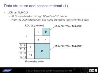
Data Structure and access method Fan Zhang Zhiqi Chen
Unordered file • Linear search Ordered file • Binary search
One to Two Dimensions • Six title index: • row order • row-prime order • Cantor-diagonal order • spiral order • Morton order • Peano-Hilbert order.
Raster Structure • chain codes • Run-length encoding (RLE) • Block encoding dimensions. Point Object Structure • Grid structure • Point quadtree • 2D-tree
Linear Objects • PM quadtrees • PM1 quadtree • PM2 quadtree • PM3 quadtree Collection of Objects • Rectangles & Minnimum bounding boxes • R-trees & R+-trees • BSP-tree
Spherical Data Structures • Provide methods to surface of the Earth • Quaternary triangular mesh (QTM)
Voronio Diagram • Decomposes a set of objects in a spatial • Variants: the k-th order, the Farthest-Site • Method to create a VoronoiDiagram • Been used in: science, astronomy, biology, nearest neighbor problem, and route planning.
R-Trees • Aimportant access method in Spatial Data Management. • A ubiquitous data structure • The splitting criteria: Linear Split, Quadratic Split, Exponential Split. • Various: R+-tree, R*-Tree, Static R-tree, Packed R-tree, Hilbert Packed R-tree, STR R-tree, Time-Evolving R-tree • Used for: processing spatial queries, spatio-temporal database, multimedia database, data warehousing and data mining. Based on the research, it covers almost every aspect of concerning a database. • Will be important in modern system and application.
R*-Trees • An efficiently access method for points and rectangles. • A popular access method in database systems organizing both multidimensional point data and spatial data. • More suitable for the more complex object representation. • Supports point and spatial data at the same time and its implementation cost is a little higher than of other R-tree variants. • R*-tree has been used in geographic information system (GIS), digital mock-up (DMU), and multidimensional feature vectors.
Mobile Object Indexing • Been used in location-aware applications • traffic monitoring, • intelligent navigation • mobile communications management
Thank you! • Any question?