Download
1 / 33

E N D
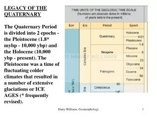
LEGACY OF THE QUATERNARY The Quaternary Period is divided into 2 epochs - the Pleistocene (1.8* mybp - 10,000 ybp) and the Holocene (10,000 ybp - present). The Pleistocene was a time of fluctuating colder climates that resulted in a number of extensive glaciations or ICE AGES (* frequently revised). Harry Williams, Geomorphology
At present, ice covers about 10% of the land surface, whereas at its maximum extent during the Pleistocene it covered about 30%. Ice cover in the northern hemisphere about 15,000 years ago. Harry Williams, Geomorphology
In the study of landforms, Pleistocene glaciation is important since many areas glaciated in the Pleistocene are still dominated by glacial landforms today, even 10,000 years after the last Ice Age ended. The reason for this is that glaciers are capable of massive erosion and deposition and leave a long-lasting imprint on the local geomorphology. If you visit the northern states, or other glaciated regions, the only way to understand the local geomorphology is to recognize that these are glacial landscapes formed by ice that is no longer present. Harry Williams, Geomorphology
In North America, two distinct types of glaciation occurred: ALPINE GLACIATION, characterized by valley glaciers, in mountainous areas of the western U.S.; and CONTINENTAL GLACIATION, characterized by large unconfined ice sheets, over much of Canada and the northern states. ALPINE GLACIATION CONTINENTAL GLACIATION Harry Williams, Geomorphology
Landforms of Alpine Glaciation EROSION is the dominant process in glaciated mountainous regions. The glaciers are confined to pre-existing steep valleys and tend to erode vertically. Wide U-shaped glacial troughs, hanging valleys, horns, cirques, aretes and truncated spurs are the result. B. Glaciated Harry Williams, Geomorphology
hills mountains Truncated Spur cliffs ridges Harry Williams, Geomorphology
Examples from North America. Cirque, Labrador, Canada. Harry Williams, Geomorphology
Tarn - lake formed in the bottom of a cirque (view down valley). Harry Williams, Geomorphology
Hanging valleys. Harry Williams, Geomorphology
Horns, aretes, cirques. Harry Williams, Geomorphology
Glacial trough, hanging valley. Harry Williams, Geomorphology
Fjord - a submerged glacial trough - common on the coast of B.C., Alaska. Harry Williams, Geomorphology
Landforms of Continental Glaciation. What causes Ice Ages? Changes in the shape of the earth’s orbit, the tilt of earth’s axis and the direction of tilt all exhibit cyclic change. Milankovitch theory describes the collective effects of these changes, which combine to cause cold climates about every 100,000 years. Harry Williams, Geomorphology
Extent of glacial deposits (“Drift”) from Pleistocene glaciations in the northern midwest. The last large glaciation was the Wisconsin. The Illinoian is an older glaciation that extended further south. Harry Williams, Geomorphology
DEPOSITION is dominant in lowland areas at the margins of continental glaciers - the northern states in North America. This is where debris carried in the ice is released as the ice melts. Further back from the ice front, (mainly in Canada) erosion can occur by SCOURING of the surface by debris (rocks) carried at the base of the ice. General scouring of the surface removed much topsoil from these areas, which is slow to recover due to the cold climates. Scouring also creates small grooves or striations or lager troughs aligned with the direction of ice flow; many larger troughs filled with water to become lakes. Harry Williams, Geomorphology
Canada Shield lakes. Harry Williams, Geomorphology
Glacial striations. Harry Williams, Geomorphology
Much of the landscape of the northern mid-west is dominated by depositional landforms. Deposition can occur directly from the ice - erratics, ground moraine, drumlins, end moraines - or from meltwater (mainly gravel, sand, mud) in the form of lake deposits, outwash (melt-water stream) deposits and eskers (sub-glacial melt-water stream deposits). Outwash and esker deposits have a similar character to alluvial deposits Harry Williams, Geomorphology
Ice-marginal areas Harry Williams, Geomorphology
Bouldery ground moraine, Canada. This debris is “plastered” onto the surface directly under the ice near the margins of the ice sheet. Harry Williams, Geomorphology
Areas of ground moraine usually are not great for farming (boulders, water-logging, hummocky). They can be used for dairy farming e.g. Wisconsin. Hence all the cheese. Harry Williams, Geomorphology
Erratics are common in ground moraine regions (this one is in Manitoba above the tree line). Erratics provide a clue to the source of ice and ice movement. Harry Williams, Geomorphology
Ice flow Drumlin, Alberta. Drumlins are formed from moraine that is pushed up into a hill by over-riding ice and then “streamlined” by the ice flow. They “point” in the direction of former ice flow. Harry Williams, Geomorphology
Drumlins, Manitoba. Harry Williams, Geomorphology
End moraine forming on Baffin Island, today. Debris carried by the ice piles up at the front of the ice sheet (where melting occurs). Harry Williams, Geomorphology
Road cut through Pleistocene end moraine, Quebec. Moraines are always mixtures of different sized sediment. Harry Williams, Geomorphology
Esker - Manitoba. These are ridges of meltwater deposits laid down in a tunnel under the ice. The sediment is usually well-sorted sand and gravel. Harry Williams, Geomorphology
Esker, Quebec. Harry Williams, Geomorphology
Outwash is sand and gravel deposited by meltwater streams that form in the summer. These streams are typically braided and create wide outwash plains. Outwash can extend 10’s of miles beyond the margin of an ice sheet. Outwash sediment has the character of alluvium (well-sorted, stratified). Harry Williams, Geomorphology
Bedrock ridge Outwash plain Outwash plains are great for farming. They are flat, well-drained and fertile. This one is in Quebec. Harry Williams, Geomorphology
Outwash plain, Skagit Valley, Washington State. Harry Williams, Geomorphology
Summary: glaciers and ice sheets cause massive erosion and deposition. They create long-lasting erosional and depositional landforms. Glacial features dominate landscapes in the northern states and Canada, even though they were formed more than 10,000 years ago. In mountainous regions, glaciers are confined to valleys, concentrating their erosion. Consequently, EROSIONAL landforms dominate - there is relatively little deposition and few depositional features. In lowland regions, large unconfined ice sheets cause general scouring of the surface, while DEPOSITIONAL features dominate marginal areas (near the ice front). Deposition can be directly from the ice (ice-contact deposits, including ground moraine, drumlins, end moraine and eskers) or can be meltwater deposits (outwash plains) extending beyond the ice limits. Harry Williams, Geomorphology