Site Selection Process
Author : Nimish Sheth, Northern Virginia Community College Geographic Information Systems I Spring 2009. Wind Farm Site Selection in Virginia. Projected Coordinate System: NAD1983 UTM Zone 17N Geographic Coordinate System: GCS North American Datum 1983 Sources :

Site Selection Process
E N D
Presentation Transcript
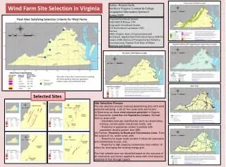
Author: Nimish Sheth, Northern Virginia Community College Geographic Information Systems I Spring 2009 Wind Farm Site Selection in Virginia Projected Coordinate System: NAD1983 UTM Zone 17N Geographic Coordinate System: GCS North American Datum 1983 Sources: NREL, Virginia Dept. of Conservation and Recreation, Appalachian Trail Conservancy, 2000 US Census, ESRI, Bureau of Transportation Statistics, Geocomm.com, Virginia Tech Dept. of Mines, Minerals, and Energy Land use restrictions preclude many areas from commercial development. Therefore, every location with the required wind resource cannot be considered for wind farm sites. This map displays federal and state conservation lands, military areas, and certain public and private lands with conservation and recreation focus. Areas with class 3 and higher wind resource falling with these boundaries have been excluded from consideration. Source: Virginia Department of Conservation and Recreation, Appalachian Trail Conservancy http://www.dcr.virginia.gov/land_conservation/tools02a.shtml http://www.appalachiantrail.org Locating wind farms in or near population centers is unfeasible for various reasons ‑ safety, insufficient land availability , public opposition, to name a few. This map shows the population density (population per square mile, 2003 census) by county. Areas with class 3 and higher wind resource falling within counties with a population density of greater than 500 have been excluded from consideration. Source: ESRI, US Census Bureau http://www.esri.com http://www.census.gov Sites with at least Class 3 wind resource meeting all criteria based on land use, population centers, roads, and transmission lines. This is a on-shore wind resource map for Virginia derived from the Mid-Atlantic resource map produced by TrueWind and validated by the National Renewable Energy Laboratory (NREL). The map displays wind resource measured as watts per square meter at 50 meters above ground, based on estimated wind speeds and classified as Class 1 (the lowest) to Class 7 (the highest). A minimum wind class of 3 (ideally 4 and higher) is considered suitable for utility-scale wind projects. Accordingly, wind classes 1 and 2 have been excluded from the analysis. Source: National Renewable Energy Laboratory http://www.windpoweringamerica.gov/maps_template.asp?stateab=va Selected Sites • Site Selection Process • The site selection process involved determining sites with wind potential satisfying a set of five constraints and factors: • (i) Determine on-shore wind resource potential in Virginia. • (ii) Constraints: Land Use and Population Centers. Exclude from (i) areas with: • - Unsuitable land use classification (such as conservation, military, certain public and private lands), and • - Proximity to population centers (counties with population density greater than 500). • (iii) Factors: Proximity to Roads and Transmission Lines. From the output of (ii), select areas with: • - Proximity to major roads ((within 5 miles) for operations and maintenance access, and, • - Proximity to high capacity transmission lines (within 10 miles) for leveraging the existing energy grid. • The final suitable sites are identified based on the outcome of all constraints and factors applied to areas with wind resource potential of Fair through Superb. Transportation access is essential for maintenance and development of wind farms and consequent cost-benefit calculations. This map, constructed from Bureau of Transportation Statistics data, shows major roads in the state, including interstates, primary highways, and other major roads. Areas with class 3 and higher wind resource lying more than 5 miles from these roads have been excluded from consideration. Source: Bureau of Transportation Statistics, National Transportation Atlas Database http://www.bts.gov/publications/national_transportation_atlas_database/2008/ Access to the existing electric grid infrastructure would minimize delivery and consumption costs incurred by building new transmission lines for grid connectivity. This map was constructed in a multi-step process, beginning with generalized transmission line data obtained from Geocomm.com. Transmission lines with high transmission capacity (classified by kilovolts (kV)) were approximated and digitized using a schematic published by Virginia Tech, Dept. of Mines, Minerals, and Energy. Areas with class 3 and higher wind resource lying more than 10 miles from these transmission lines have been excluded from consideration. Source: GeoCommunity, Virginia Tech Dept. of Mines, Minerals, and Energy http://data.geocomm.com/ http://www.energy.vt.edu/vept/electric/vapowerlines.asp