Download
1 / 11
110 likes | 264 Vues
Towards a Fundamental Global IR Radiance Decadal Data Record. Sponsor: Innovim Corp. PI M. Halem, PD. C.C. Wu Students: P. Nguyen, D. Chapman. Tracking Climate Changes from Satellite Radiances.

E N D
Towards a Fundamental Global IR Radiance Decadal Data Record Sponsor: Innovim Corp. PI M. Halem, PD. C.C. Wu Students: P. Nguyen, D. Chapman
Tracking Climate Changes from Satellite Radiances • NASA, NOAA and DOD have collected large volumes (Petabytes) of satellite Infrared Radiance (IR) data for the past 40 years which are stored in various archives and formats and on different storage media. • Gridded data records of Level 1B IR measurements for AIRS/HIRS/VTPR and MODIS/AVHRR data have many advantages for climate studies but are not available today as products • AIRS is hyperspectral with 2378 channels spanning 3.7um to 15.4 um ~14km and 4 Vis channels at 0.41 - 0.44 μm, 0.58 - 0.68 μm, 0.71 - 0.92 μm and 0.49 - 0.94 μm at ~1km • MODIS is hyperspatial with 16 IR spectral bands 3.6 um 14.3 um at 1km and 20 Vis channels several corresponding to AVHRR. • Aqua expected to be operational until 2013. If AIRS/MODIS instruments continue to operate, we show this data can form a Fundamental Decadal Data Record (FDDR). This is basis of our approach to forming a HIRS/AVHRR gridded FCDR:
Service Oriented Atmospheric Radiance (SOAR) • Developed web based system with an interface for accessing and invoking gridding and analysis services on level 1B Infra-red radiance data • Employs SOA technologies to discover and select services for use of multi -sensor infra-red radiances • Serves up pre-gridded (lat-lon) AIRS and MODIS IR spectral radiances on-demand and requested image and/or structured data formats • Provides a platform for users to exploit IR data for climate analysis with traditional methodologies
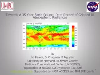
Why we need SOAR Maps level 1B granules into gridded level 3 radiances Advantages: • Increases usability by scientists (modeling & visualization tools, climate processing, etc.) • Analysis services based directly on observations • Greatly reduces data volume (lossy compression) • A common framework for multi instruments • No level 3 gridded radiance products available from AIRS and MODIS instrument teams • Produced 1st multi-year (5) global fundamental IR radiance brightness temperatures. http://bluegrit.cs.umbc.edu/soar
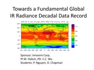
AIRS global yearly average BT 3.83μ 1x0.5o 5 year average
AIRS season average • AIRS BT seasoning different from 2004, 2007 year all season average by latitude 3.83μ 1x0.5o
Summary • We have shown that SOAR gridded data records of Level 1B IR measurements from AIRS data on Aqua offers many advantages to increase community access • Fundamental data products are not available operationally. • Aqua expected to be operational until 2013, If AIRS instruments continue to function as today, these data will form the basis of an unprecedented Fundamental Climate Data Record (FCDR) • Collaborating with NOAA AOML Hurricane Research Division to conduct hurricane forecast impact tests by providing them with calibrated super resolved IR radiances (10, 5, 3 km ) in real time in and around hurricanes.