Ice, Cloud, and Land Elevation Satellite (ICESat-2) Science Data System
150 likes | 398 Vues
Science Data Systems in the Decadal Survey Era Presented at ESDSWG, Wilmington, DE David Hancock, Ed Chang, John DiMarzio 10/21/2009. Ice, Cloud, and Land Elevation Satellite (ICESat-2) Science Data System. ICESat-2 Mission. Science Objectives

Ice, Cloud, and Land Elevation Satellite (ICESat-2) Science Data System
E N D
Presentation Transcript
Science Data Systems in the Decadal Survey Era Presented at ESDSWG, Wilmington, DE David Hancock, Ed Chang, John DiMarzio 10/21/2009 Ice, Cloud, and Land Elevation Satellite (ICESat-2) Science Data System
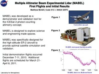
ICESat-2 Mission • Science Objectives • Determine polar ice sheet mass balance; understand controlling mechanisms; examine how ice sheets will impact global sea level and ocean circulation in a changing climate. • Measure sea-ice thickness to understand ice/ocean/atmosphere exchanges of energy, mass and moisture. • ATLAS (instrument) Operations Concept • Operations similar to ICESat • Advanced Topographic Laser Altimeter System (ATLAS)- New Micro Pulse Altimeter, High PRF, low pulse energy, Multi-beam photon counting system • Repeat ICESat ground-track • Orbit: 600 km, circ, 94° inclination, 91-day repeat • Pointing accuracy ± 10 arcseconds (± 30 m on ground) • Mission Status • Currently in Pre-Phase A (dMCR scheduled 1st week in November) • KDP-A December, 2009 • KDP-B June, 2010 • KDP-C January, 2012 • Launch October, 2015
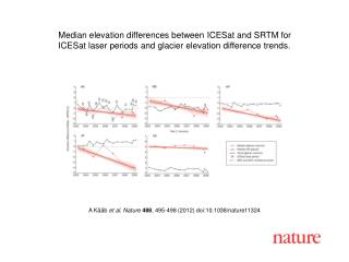
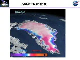
ICESat dH/dt ThinningThickening ICESat - Climate Change Ice Thickness Change (2003 to 2007) • ICESat results over 4-year period have been critical to defining the recent rate of mass loss (148 Gt/yr) from Greenland and the changes from the near-zero loss in the 1990’s. • Losses are concentrated at the margins in the South and Central regions. • The ice sheet continues to thicken inland, as it did in the 1990s, but thinning at the margins has increased significantly due to increased summer melting and acceleration of outlet glaciers. • Highlights importance of ice margins.
Key Science Data System Concepts Similar to ICESat ICESat Science Investigator-led Processing System (SIPS) implements the science team ATBDs into Science Algorithm Software, Produces Standard data products, distributes products to science team and public archive (Estimate 40% re-use) Level Zero Processor provides level 0 data to SIPS Precise Orbit and Pointing (POD/PAD) is provided by science team (Requirements same as ICESat) GES DAAC provides required ancillary atmospheric data (Existing standard data product) Science Computing Facility ( Project Science Office) provides standard data product production and distribution to Science Team National Snow and Ice Data Center (NSIDC) provides final data archive and data distribution to public (Existing Multi-Mission high re-use)
Ground System Data Flow Concept proven by ICESat
ICESat-2 Science Data Systems Key Requirements ICESat-2 carries single science instrument ATLAS ( Advanced Topographic Laser Altimeter System) SDS Requirements VERY MUCH LIKE PRESENT ICESat’s Receive Level 0 science data from the Level Zero Processor Process Level 0 data into standard science data products Distribute standard science data products to science team Distribute products for public release to NSIDC Reprocess for algorithm improvements and tuned PAD Reprocess to final dataset within one year of EOM Implement, maintain and update Science Algorithm Software based on ATBDs
Use ICESat Ground System Lessons Learned ICESat Ground system was highly successful Test data during instrument integration provided early flow testing Separated standard data processing from science team data request H/W capacity and upgrade planning was very good. Plan for adequate reprocessing and algorithm update worked. Metadata interface needs improvements Need to test contingency plans at planned interval (at least annually) Security compliance was much more work than planned Once in operation, plan quarterly reviews to identify bottlenecks including data distribution
Science Investigator-led Process System(SIPS) – Operation and Data Products Operate 24 x 7 with 10 x 5 staff except scheduled maintenance Process products for one day at 6X real time Ingest Level 0 Data Volume: 61 GBytes per day Data Products: 4-L1A, 3-L1B, 4-L2, 4- L3 Output Data Volume : ~360 GBytes per day (includes level 0, first release, reprocessed release)
SIPS Functional Diagram(Re-use of ICESat estimates noted) Goddard Space Flight Center Scheduling System Infrastructure Services Logging, Operator Prompts External Systems NSIDC LZP SCF ISF UTCSR ATLAS Planning Ingest and Distribution Distribution Planning ATLAS Science Algorithms Data Mgmt./Archive Production Database External System SDMS 90% Re-use Processing Control ~60% re-use Science Software 40% re-use Data Control DBMS Schedule Legend 9
Standard Data Products ICESat like products Level 1 – ATLAS data converted to engineering units and calibrated for instrument prelaunch effects. Level 1B – ATLAS global products processed with science calibrations and parameters. Level 2 – ATLAS products with Geophysical parameters processed relative to surface type Level 3 Ice sheet DEM and sea ice freeboard Considering New Level 3 global products for Atmosphere and Vegetation
ICESat-2 – Science Data ProcessingTypical Day in the Life During Year 2
ICESat-2 – Science Data ProcessingData Storage, Archive and Distribution • SIPS archive maintains latest two versions of products on RAID disk • SIPS distributes to Science Computing Facility for Science Team evaluation and use • Data distributed to NSIDC for permanent archive and public distribution
ICESat-2 Science Data System Summary • Currently ICESat-2 Mission plans for heritage ground system based on ICESat's design. • Current data systems are capable of handling processing loads, storage and data transfer to support the Mission. • SIPS system based on SDMS re-use and selection of COTS database software. • Science processing software modified to handle changes to the laser altimeter • Selection of new hardware technologies planned for processing speed and storage requirements • Need to meet with ESDSWG working group leads to learn more on each subgroups work and how we as a mission can leverage these