Carrying Capacity (CC) and LAC
400 likes | 805 Vues
Carrying Capacity (CC) and LAC. Recreation Opportunity Spectrum (ROS). Increased use Increased development. Roaded Natural. Primitive. Semi- Primitive Non-motor. Semi- Primitive Motorized. Rural. Urban. Why is monitoring important?. Identify existing and desired position on ROS

Carrying Capacity (CC) and LAC
E N D
Presentation Transcript
Recreation Opportunity Spectrum (ROS) Increased use Increased development Roaded Natural Primitive Semi-Primitive Non-motor Semi- Primitive Motorized Rural Urban
Why is monitoring important? • Identify existing and desired position on ROS • Promote accountability by park and resource managers • Foster user support for agencies • Identify increased demand • Provide feedback for better planning and management • Identify all impacts, not just economic
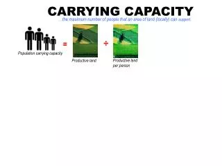
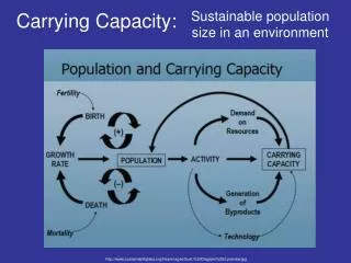
What is carrying capacity? Definition: • The maximum level of use that an area or resource can sustain before deterioration occurs.
Types of Carrying Capacity • Ecological or biological • Social and psychological • Physical (facility) • Managerial
What do we measure? • Minimum numbers (at which a park is viable) • Maximum numbers
What do we manage for? • Optimum range
What do we manage for? Minimum (managerial CC) Maximum (mng. CC)
What do we manage for? Maximum (social CC)
What do we manage for? Maximum (env. CC)
What do we manage for? • Optimum range Minimum (managerial CC) Maximum (env. & social CC)
Problem with CC... • Often the impacts have already occurred by the time the CC is determined • No ecosystem is static, but CC is! • Difficult to implement in multiple use areas • 10 hikers • 8 hikers and 2 mountain bikers • 5 hikers and 5 mountain bikers • 3 hikers and 7 mountain bikers
What is LAC? • A process which requires managers to: • define desired resource conditions and • take actions to maintain or achieve those conditions It does not prevent changes but instead minimizes them!
Some details about LAC... • Monitoring-based resource assessment method • Considers preservation or conservation versus use • Based on ROS classes • Sets standards of use and management • Public involvement process
LAC is NOT Carrying Capacity • Issue is not numbers for LAC, but IMPACTS • For example: • 10 hikers • 8 hikers and 2 mountain bikers • 5 hikers and 5 mountain bikers • 3 hikers and 7 mountain bikers
Four Major Components of LAC • Specify acceptable and achievable resource and social conditions. • Analyze the relationship between existing conditions and acceptable conditions.
Four Major Components of LAC • Identify management actions necessary to achieve the desired conditions. • Monitor and evaluate the effectiveness of management actions.
Step 1 - Identify area issues and concerns • Identify public issues and managerial concerns that relate to: • Distinctive features and characteristics of the area. • Use of the area by people. • The relationship of the area to other similar units and to other local areas
Step 2--Define & describe opportunity classes • Identify ROS Opportunity Classes that generally describe the area • Each park area can have multiple classes Roaded Natural Primitive Semi-Primitive Non-motor Semi- Primitive Motorized Rural Urban
Step 2--Define & describe opportunity classes • Describe the kinds of resource, social, and managementconditions acceptable for the class • Example: Primitive ROS class: • Resource: Minimal impacts on resource • Social: Solitude • Management: Minimal facility development • Management: No motorized vehicle use
Step 3—Select indicators of resource & social conditions • Indicators: Specific variables that indicate the condition of the opportunity class • Example: solitude - number of people encountered
Step 3—Select indicators of resource & social conditions • Indicators must be: • accurate • capable of being measured in a cost effective way • related to the use occurring • responsive to management control.
Why are indicators important? • Allow managers to: • Unambiguously define desired conditions • Assess the effectiveness of various management practices
Indicators for primitive ROS class • Minimal impacts on resource: • Loss of vegetation along trails • Solitude: • Few encounters with other people
Step 4 — Inventory existing conditions • Use indicators from Step 3 to inventory existing conditions. • This is a critical step in determining what and where management is needed.
Inventory Park entrance Rural Roaded natural Primitive
Step 5—Specify standards for indicators • Assign standards (i.e., quantitative measures) to indicators (from Step 3) • Standards provide a BASELINE against which conditions can be judged • Judgmental process, but logical, traceable, and subject to public review
Standards for primitive ROS class • Minimal impacts on resource: • Indicator: Loss of vegetation along trails • Standard: Trail width no more than 2 feet • Solitude: • Indicator: Few encounters with others • Standard: 0 - 1 encounters/day
Step 6—Identify alternative opportunity class allocations • Decide what our ROS alternatives are • A diversity of opportunity classes may be represented in one park. • Balance desired conditions with reality • Need input from both managers & users
What we have... Park entrance Rural Roaded natural Primitive
Alternative 1: What we want... Park entrance Rural Roaded natural Primitive
Alternative 2: What we want... Park entrance Rural Primitive
Alternative 3: What we want... Park entrance Rural Roaded natural Primitive
Step 7—Identify management actions for each alternative • For each alternative, identify differences between current conditions (step 4) and the standards (step 5) • When conditions exceed standards, there is no need for management • When conditions are close to or worse than standards, management is necessary • Design management strategies for each alternative.
Compare standards... • Minimal impacts on resource: • Indicator: Loss of vegetation along trails • Standard: Trail width no more than 2 feet • What we have: Trail width of 1 foot • Management strategy? • Solitude: • Indicator: Few encounters with others • Standard: 0 - 1 encounters/day • What we have: 5 encounters/day • Management strategy?
Step 8—Evaluate and select a preferred alternative • Selections is made by managers and local residents…no formula • Considerations: • What user groups are affected and how? • What values are promoted or diminished? • Does the alternative contribute to park/wilderness system diversity? • What is feasible (personnel, budget…)?
Step 9—Implement actions & monitor conditions • Systematic feedback on how well management actions are working • Identify trends in conditions that require new actions • Show what type of management actions solve what type of problems
Identify an indicator and standard for... • Roaded Natural campground which is having difficulty with conflicts between campers.
Identify an indicator and standard for... • Primitive area which is managed for an endangered animal species.