Download

1 / 5
Indiana Map Mash-up: High-resolution GIS Grid around ICTC Building CGL-POLIS Server
50 likes | 142 Vues
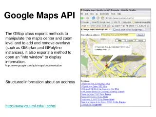
Explore the highest resolution Google Maps around the ICTC Building CGL-POLIS Server with parcels data. This mash-up integrates Indiana Map and approximately 10 counties' data, offering a federated grid of diverse information sources. Access various feature servers from different vendors. Similar to astronomy's Virtual Observatory concept, this grid federates multiple data repositories for a comprehensive view.
Télécharger la présentation 
Indiana Map Mash-up: High-resolution GIS Grid around ICTC Building CGL-POLIS Server
An Image/Link below is provided (as is) to download presentation
Download Policy: Content on the Website is provided to you AS IS for your information and personal use and may not be sold / licensed / shared on other websites without getting consent from its author.
Content is provided to you AS IS for your information and personal use only.
Download presentation by click this link.
While downloading, if for some reason you are not able to download a presentation, the publisher may have deleted the file from their server.
During download, if you can't get a presentation, the file might be deleted by the publisher.
E N D
Presentation Transcript
CGL-POLIS Server with highest resolution around ICTC building
Indiana Map Mash-up GIS Grid of “Indiana Map” and ~10 Indiana counties with accessible Map (Feature) Servers from different vendors. Grids federate different data repositories (cf Astronomy VO federating different observatory collections


More Related