Google Maps API
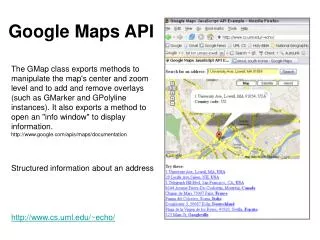
Google Maps API. Static Maps. send an HTTP GET request receive an image (PNG, GIF, JPEG) no javascript needed encode params in URL example: http:// maps.googleapis.com/maps/api/staticmap? param1=val1&param2=val2 . Static Maps. embed using the " src " attribute of the < img > tag.

Google Maps API
E N D
Presentation Transcript
Static Maps • send an HTTP GET request • receive an image (PNG, GIF, JPEG) • no javascriptneeded • encode params in URL • example: http://maps.googleapis.com/maps/api/staticmap?param1=val1¶m2=val2 ...
Static Maps • embed using the "src" attribute of the <img> tag. • some parameters: • cetner: "lat,long" or "string address" • zoom, size, scale • path, markers • sensor
Static Maps • http://maps.googleapis.com/maps/api/staticmap?center=Brooklyn+Bridge,New+York,NY&zoom=14&size=512x512&maptype=roadmap &markers=color:blue%7Clabel:S%7C40.702147,-74.015794&markers=color:green%7Clabel:G%7C40.711614,-74.012318 &markers=color:red%7Ccolor:red%7Clabel:C%7C40.718217,-73.998284&sensor=false
Static Maps • Documentation: https://developers.google.com/maps/documentation/staticmaps/
Javscript API • embed Google Maps in web pages. • provides functions to manipulate maps • free • new: API key optional • https://developers.google.com/maps/documentation/javascript/
Javscript API • reference the API libraries in the <head> • embed the map canvas in the web page: <scripttype="text/javascript" src="http://maps.googleapis.com/maps/api/js?&sensor=false"> </script> <divid="map_canvas"></div>
Loading the API • Browser must load Maps API (js code) from Google. • client code should not run until after the API has finished loading. • e.g. if you call the API functions in initialize: • <bodyonload="initialize()"> • <divid="map_canvas"></div> • </body>
A Simple Map • a map object takes an html elementand an options object: varmap = newgoogle.maps.Map( document.getElementById("map_canvas"), myOptions );
A Simple Map • myOptions is a JS object, specified using JSON: • where location is a LatLngobject: • many more options are available varmyOptions = { center: location, zoom: 12, mapTypeId: google.maps.MapTypeId.ROADMAP }; varlocation = newgoogle.maps.LatLng(40.4, -79.9);
A Simple Map • a LatLng object specifies a location: • and the map type can be: • google.maps.MapTypeId.ROADMAP • google.maps.MapTypeId.TERRAIN • google.maps.MapTypeId.SATELLITE varlocation = newgoogle.maps.LatLng(40.4, -79.9);
Create a Map • full code listing: functioninitialize() { varlocation = newgoogle.maps.LatLng(40.4, -79.9); varmyOptions = { center: location, zoom: 12, mapTypeId: google.maps.MapTypeId.ROADMAP }; varmap = newgoogle.maps.Map( document.getElementById("map_canvas"), myOptions ); }
Placing Markers • markers indicate points of interest • marker options specify: location, icon, etc. • set the marker using setMap() varoptions = { position: newgoogle.maps.LatLng(-27.463347, 153.02496) }; varmarker = newgoogle.maps.Marker(options); marker.setMap(map); // set the marker on the map
Interactive Maps • you can add event handlers to the map: • example: show the (lat,lng) when the user clicks on the map. // in the init function(): google.maps.event.addListener(map, 'click', onMapClick); functiononMapClick(details) { alert(details.latLng); }
Street View functioninitialize() { varmyOptions = { position: newgoogle.maps.LatLng(40.44285, -79.952960), pov: { heading: 0.0, pitch: 20, zoom: 1 } }; varpano = newgoogle.maps.StreetViewPanorama( document.getElementById('map_canvas'), myOptions); }
Geocoding & reverse Geocoding • convert an address to (lat,lng) vargeocoder = newgoogle.maps.Geocoder(); varrequest = { address: "48 Pirrama Rd, Pyrmont" }; geocoder.geocode(request, function(results, status) { if(status == google.maps.GeocoderStatus.OK) { // center map on location ... } else{ // log error to console ... } });
Not covered • other things you can do: • animate markers • markers in street view • info windows • elevation • directions • shapes & lines