Maryland’s Coastal Atlas: Ocean & Estuary Mapping Tools
210 likes | 233 Vues
Explore Maryland's Coastal Atlas online mapping tool for coastal and ocean planning. Identify potential conflicts and access data for better decision-making. Useful for regulators, planners, researchers, and citizens.

Maryland’s Coastal Atlas: Ocean & Estuary Mapping Tools
E N D
Presentation Transcript
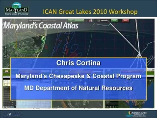
ICAN Great Lakes 2010 Workshop Chris Cortina Maryland’s Chesapeake & Coastal Program MD Department of Natural Resources
Maryland’s Coastal Atlas:What is it? • The Coastal Atlas is an online mapping and planning tool that allows state and local decision-makers to analyze and explore data for coastal and ocean planning activities. • Our ocean and estuarine environments today face an era of unprecedented activity: • Wind farms and other energy facilities, commercial fishing, diverse recreational uses, and shipping highways are all competing for use and space. • To ensure the protection of Maryland’s critical ocean and estuarine resources, the Coastal Atlas has been developed to provide direct access to available data needed for coastal and ocean planning efforts. • Coastal Atlas will assist users in identifying potential conflicts so that they can then be avoided early in the planning process. • The tools currently available are designed to support better decision-making by compiling available data into one place where information can be tailored for specific issues.
Maryland’s Coastal Atlas:Audience • Coastal zone managers/regulators • Coastal hazards mitigation specialists • Local land use planners • Non-government organizations • Researchers • Educators • Offshore wind energy developers • Developers/Real estate professionals • Private citizens
Maryland’s Coastal Atlas:Update • Funding from NOAA CZMA grant, administered through MD-CCP • Major drivers for update: • Governor OMalley’s emphasis and enthusiasm for better decision-making, communication and transparency through GIS (StateStat, CityStat, GreenPrint, etc) • CZM/MD-CCP investment in MD iMap • Developed and hosted by Towson CGIS • From ArcIMS to ArcGIS Server / Adobe Flex • From one mapping tool (Maryland Shorelines Online) to three (Ocean, Shorelines, Estuaries) Previews conducted w/ stakeholder groups • Immediate application for offshore wind energy • Launched in June 2010
MD iMap:How the Atlas was developed • MD iMap is the state data infrastructure hosted at Towson University Center for GIS • Centralized collection of the most commonly used map data, Maryland data layers, tools and services hosted in ESRI ArcGIS Server environment (roads, streams, place names, government boundaries, property information and detailed imagery) • Data is available as web services to state and local government so they don’t have to store or host data • The framework for application development (Adobe Flex) allows state and locals to develop applications that can pull in the data/web services they want to display • iMap ensures data/web services look the same across all state mapping applications
Maryland’s Coastal Atlas:Launch February 2010Preview Launch of Coastal Atlas April 2010Stakeholder Informational Open Houses: Annapolis, Ocean City May and June, 2010Commercial fishing scoping and mapping meeting May - PresentOngoing outreach and dialogue with fisheries stakeholders, DNR resource managers and other user communities May and June, 2010Recreational fishing mapping efforts April 2010DNR Coastal Fisheries Advisory Committee and one-on-one meetings; maps distributed June, 2010DNR launches Coastal Atlas (Ocean & Shorelines) on World Oceans Day March 1, 2010Wind developer response to RFEOI The State’s interest in offshore wind energy provided a significant accelerator to the Coastal Atlas development and launch
Maryland’s Coastal Atlas:Mapping Tools • To help concerned citizens address specific coastal issues, the Coastal Atlas offers several mapping applications: • Ocean • Allows users to view ocean data and access tools to understand and balance multiple ocean uses, including shipping, offshore renewable energy, recreation and fishing. • Shorelines • Allows users to access state shoreline erosion data, understand basic information about coastal inundation and identify areas at risk to sea level rise. • Estuaries • Allows users to identify and access critical tidal and near-shore habitats for targeted conservation, protection and restoration activities such as tidal wetlands, priority finfish habitat and submerged aquatic vegetation.
Maryland’s Coastal Atlas:Ocean The Ocean mapping tool allows users to view ocean data and access tools to understand and balance multiple ocean uses, including shipping, offshore renewable energy, recreation and fishing. • Data: Administrative, Human Uses, Biological and Geophysical • Data acquisition: Multi-partnered collection effort w/ TNC, MEA, UMD, AWSTruepower, State agencies • Potential applications for this tool include: • Accessing information needed for coastal and ocean planning efforts • Finding the best location for renewable energy projects • Identifying potential conflicts so that they can then be avoided early in the planning process • Locating sand resources needed for beach replenishment
Maryland’s Coastal Atlas:Shorelines The Shorelines mapping tool allows users to access state shoreline erosion data, visualize coastal inundation from storms and identify areas at risk to sea level rise. • Data: Shoreline Change, SLR Vulnerability, Storm Surge, LS suitability, Erosion Vulnerability (EVA) • Data acquisition: Multi-partnered effort w/ VIMS, State agencies • Potential applications for this tool include: • Aiding shoreline management decisions by identifying areas of high erosion and a way to visualize potential shoreline positions in 50 years • Identifying coastal areas subject to coastal flooding from storm inundation and sea level rise for long-range planning, floodplain management, and emergency management • Accessing the Comprehensive Shoreline Inventory – includes county by county info on riparian land use, bank condition, and shoreline features to assist local/state policy development • Determining areas where living shorelines are appropriate for a limited number of counties
Maryland’s Coastal Atlas:Estuaries The Estuaries mapping tool allows users to identify critical tidal and near-shore aquatic resources and habitats and their surrounding landscapes to focus conservation and management activities. • Data: Living Resources (habitat, spawning areas), Shoreline (BI ranks), Environmental, MD Coastal Bays • Data acquisition: DNR, TUGIS, State agencies • Potential applications for this tool include: • Accessing results of the Blue Infrastructure Near-shore Assessment - a detailed spatial assessment of coastal habitat, critical natural resources and associated human uses in the tidal waters and near-shore area of Maryland's coastal zone • Enhancing the scope of information and aquatic resource values considered in land acquisition in coastal areas • Helping coastal managers and planners identify coastal habitats where conservation and restoration activities can maintain and improve coastal resources
Maryland’s Coastal Atlas:Functionality Tools • Measure • Identify • Zoom • Address Search
Maryland’s Coastal Atlas:Functionality Zoom Or SHIFT and drag mouse
Maryland’s Coastal Atlas:Functionality Draw/Measure
Maryland’s Coastal Atlas:Functionality Address Search
Maryland’s Coastal Atlas:Functionality Additional Tools • Photos • Graphs/Charts • Reports (from a selection) • Print/Print to PDF/Print to JPG or PNG
Maryland’s Coastal Atlas:Coming Soon New Data, Tools and Functionality • Improve the data displayed by the Identify tool • Add a Lat/Long display that shows the coordinates as the cursor moves around the map • More complete satellite data coverage • Advanced geoprocessing tasks will be developed (in addition to current measure and draw functionality) • Take advantage of Adobe Flex technology, Display data in reports/tables/graphs • Enhance print function (print to PDF, send to e-mail/JPG and print to large format) and adding the ability to include a customized title and legend (and perhaps author) • Explore ability to draw polygons, label and save in order to export/e-mail or print the map image, legend and associated report (MarineMap is an example) • Bring in parcel map service • Updated county Critical area lines • More detailed shipping lane/vessel traffic data • Development of Decision Support Tools: • Screening Tools for Environmental Review/Critical Areas • Maryland’s Enforceable Coastal Policies – Federal Consistency Screening
Maryland’s Coastal Atlas:Next Steps • Continuing to work with Towson CGIS and Maryland Environmental Service (MES) to expand functionality, develop tools and add new data. • The Chesapeake & Coastal Program plans to offer training opportunities to help users make the most of the data and tools found on the Coastal Atlas. • CCP has expressed our interested in receiving comments on the Coastal Atlas as well as feedback on the data and tools needed to help users address specific coastal issues. • For questions, additional information or to view Maryland’s Coastal Atlas, visit: http://dnr.maryland.gov/ccp/coastalatlas/ E-mail: ccortina@dnr.state.md.us